The Deep Roots of Post-Wildfire Restoration
In the wild expanses of North America, specialists recognize that fire plays an important role in the forest ecosystem. Sometimes a forest cannot live without it, and often fire can’t be avoided. In fact, certain fire-adapted species of plants require the heat of a wildfire to spur germination. In some cases, fire cannot be controlled, and in some instances the best thing to do about it, experts say, is to watch the spectacle from a respectable distance with an eye toward safe evacuation routes.
When a forest and human habitation come into close proximity, the struggle over fire takes on the character of a double-edged sword. Nonetheless, experts agree that the hazards fire represents do not end when the flames are extinguished. Chief among these hazards in the western United States, where wildfires are among the dominant natural land-shaping events, is the danger of erosion.
Although wild-land fires have the potential to burn anywhere, they don’t have the same impact everywhere, says Sam Lindblom, director of land management for The Nature Conservancy, Virginia. Lindblom says he “spends a lot of time thinking about fire.” The history of fire, he says, mirrors the history of the North American continent: Not only did fires erupt regularly throughout the continent before human intervention, but once humans arrived in North America fire became a valuable tool. The original inhabitants of the continent used wildfires intentionally, “for many purposes,” notes Lindblom. “They used it to clear routes for travel, and to aid in hunting by treating the ground to create attractive areas for the bison and other animals to graze. They used it to clear land for agriculture. They used it in warfare and for defensive purposes.” Subsequent waves of settlers moving westward from the crowded eastern cities of the 19th century United States also used wild-land fire extensively, as a tool to quickly clear land for settlement and agriculture. Lindblom says, however, that in the late 1800s, “campaigns were started to reduce the use of fire.” In the early 1900s, after a series of dry years and a spate of severe wildfires, “a whole series of policies were adopted restricting the use of fire and focusing on rapidly extinguishing every wildfire, whether it was caused by nature or man.”
These policies included what came to be known as the “10 a.m. policy,” a rule holding that all fires must be extinguished before 10 a.m. the following day. “That has led up to the situation we have now, where we have the buildup of dangerous fuels,” says Lindblom. It has since been recognized that fire is a natural part of healthy wild-land ecosystems, and recently the pendulum has begun to swing back toward allowing many natural fires to burn. Yet the debate continues. “Fire policy in the United States has been evolving since the beginning; just when we think we know something, we learn something new.”
Although erosion is one of the dramatic problems associated with the aftermath of wildfire, severe erosion is in fact a rarity that depends upon conditions being just right, he notes. “It’s a problem in the most severely drought-stricken areas, only after the hottest and most severe fires,” says Lindblom, and even then is dependent on the slope, soil, and, most importantly, on precipitation.
To illustrate the diverse nature of fire’s aftermath, he says, “I’ve never heard of severe erosion caused by a fire happening in the East. The plant systems there hold more moisture, the plants are more productive, and vegetated areas tend to grow back more quickly.”
However, there are a lot of places in the West where fire-induced erosion and landslide risks do loom. During one week in early July 2015, there were 39 major wildfires burning simultaneously in the United States, each affecting 100 acres or more. Most of them were in the Western states. Meanwhile, a years-long drought has taken hold in those same Western states, which, coupled with decades of fire prevention efforts, have burdened many formerly healthy forest tracts with dense, dry underbrush, creating the ideal conditions for powerful infernos hot enough to turn the soil into a sterile hydrophobic crust. Combined with harsh episodic rainfall events that are predicted to intensify with climate change, these conditions set the stage for major post-fire erosion. Even with this horror show of worst-case scenarios, experts usually recommend erosion control measures and treatments for only the small fraction of burned areas that adjoin urban areas, residences, or infrastructure—which nonetheless accounts for vast acreage.
Just as all of these fires affect different landscapes, burn with varying intensities, and threaten different assets, there are differing approaches to handling the aftermath of each newly fire-scarred landscape. Fortunately, there are a variety of viable solutions to meet the many peculiar situations that may arise in the wake of severe fire.
What science knows is that different ecosystems recover at varying rates, that the recovery process takes time, and that during that time the ground must hold until the first generation of plants establishes itself in order for the cycle to renew. Erosion control measures can play a vital role in providing that window of time when nature might need little help.
How Hot Was It? It Was So Hot That . . .
When Vince Morris, president of Ertec, walked out into what used to be the beautiful community of formerly stately homes and forested lots in Running Springs, CA, shortly after the San Bernardino fires in 2007, the scene was almost surreal. “It was like a moonscape,” he says. Some of the trees, charred though they were, were still there, “but everything else was gone. On one block all of the houses were gone except for one—it was untouched and the homeowner was out there watering his lawn, trimming his roses; his entire property was intact. Pretty much everything else was down to the foundations. Vegetation was completely gone—lots of potential for loss of soil. It was a pretty vast area.”
Mike Alberson, currently stormwater program manager for southwest divisions for Apex Companies, was hired by San Bernardino County to develop stormwater pollution prevention plans for Running Springs after the fire. He marvels at the energy released during the fire. “It’s hard to believe how hot it can be. It would take a copper pipe and melt it down into a puddle,” he says.
According to the San Diego Wildfires Education Project, before the 2007 fires in southern California were brought under control, 7,344 separate fires had burned 370,998 acres. While some fires were caused by nature, others were man-made. According to Alberson, the San Bernardino fire was both: a lightning strike to malfunctioning power infrastructure set the spark.
After such a wave of destruction, says Morris, on average, first-year post-fire watershed sediment yield is 35 times greater than that from comparable unburned areas.
Clearing and Cleaning
Before replanting the site could even be considered the first priority was cleanup. “When you first get into it, you’re dealing with so much hazmat material. We were there to make sure to control the stormwater aspect,” says Alberson. Hazardous materials come from the homes, vehicles, and the residue of household chemicals and combusted building materials, all of which needed to be contained and removed along with the surface layer of any impacted or contaminated soils. After testing the soil for hazards such as arsenic and asbestos, and hauling away the most offensive material to hazardous waste disposal sites, restoration workers could operate safe from contamination. Alberson says the first order of business was installation of perimeter controls.
“The original specs called for silt fences. We were thinking of something maybe of a little higher grade; they didn’t want to do that, so we had the erosion control company put in regular silt fence. It was in about a week, and, lo and behold, we got about a 3-foot snow. There had been close to 5,000 linear feet [of fence] that had been installed, and every bit of it went on the ground,” says Alberson. “So they said, ‘Well, that didn’t work. What do you think we can do?'”
On the steep slopes, says Alberson, the silt fence could just as easily have been blown out by rainwater build up behind the fences during a heavy rainstorm, allowing water loaded with sediment and ash to pollute nearby streams.
He had heard of Ertec’s product, the S-Fence, but had not yet used it on a project. “Fish and Game had been telling us this BMP is going to have to be here long-term—up to five years to help reestablish the situation,” he recalls. He says durability is one of the attributes of the S-Fence that Ertec highlights, so he “decided to start with a small quantity to see how it would work out.”
Not being familiar with the product, he brought in about 10,000 linear feet and experimented with a few different installation techniques, from hog ties to staples. “The best way was to attach a stake with a drywall screw with a 2-inch overlap at each end and a stake in the middle,” he says. “So you took fewer stakes than a wattle, and it was easier to install than a silt fence.”
San Bernardino County eventually purchased about 50,000 linear feet of Ertec’s 10-inch S-Fence for the project. It was trenched in to a depth of 3 inches in areas where concentrated flow was expected. As homeowners stabilized their lots, the S-Fence was removed and relocated. “We would install the product; they would go in and clean up the area and as they finished it we stabilized it by using a native seed approved by Fish and Game. We would spray it all with [Profile Products’] Flexterra, and pack it, and once the plants started growing we would remove the temporary BMPs and move on to the next site. We took that 50,000 linear feet and used it enough times to cover 250,000—we used it four times or five times.” Alberson says the project spanned about a year and eight months, and when it was completed, there was product left over for possible reuse yet again. “Some of the S-Fence is still on the mountain—in those areas where Fish and Game said we had to leave it—and some of the product is back in the warehouse with San Bernardino County.”
Along with the S-Fence for perimeter control, says Alberson, “We used a lot of Flexterra, we used a lot of mulch as well—they had lost so many trees on the mountain that they were grinding up the burnt trees and spreading that and using it for mulch.” But because of the sheer number of trees that were being ground up, the mulch “got so thick in some areas, as much as four to six feet deep, that it caught fire from the self-generated heat in the pile.” Although these fires were relatively small, says Alberson, once they were extinguished, “we decided that rather than using the mulch they were making from burnt trees, we would just spray it. They’d had enough of fires at that point.”
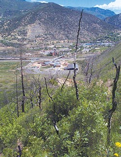
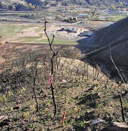
The site of a coal seam fire near Glenwood Springs, CO
A Restoration That Sticks
An infamous coal seam fire that had been smoldering for 100 years burst out violently in 2002 to devour the arid Colorado landscape. An inferno dating back, perhaps, to a mine explosion in 1896 that killed 49 miners, the fire that erupted to the surface and tore toward Glenwood Springs claimed 12,000 acres and 29 homes before it was doused just short of reaching the urban zone. Fortunately, it was brought under control without any loss of life.
Just after the fire, however, things did not look good for the hillside on the edge of the historic town known for its hot springs and a brief stint as mining hub. A new peril of potentially devastating erosion loomed over the city. “Right after the fire, everything was torched,” says Tom Bowman, president of Bowman Construction, describing the view from that hill over looking the town. He says everything was stripped bare and poised for a major erosive event.
It was the kind of scene the US Geological Survey warns of in documents relating to post-fire landslide risk on its website: “Post-fire landslide hazards include fast-moving, highly destructive debris flows that can occur in the year immediately after wildfires in response to high intensity rainfall events, and those flows that are generated over longer time periods accompanied by root decay and loss of soil strength. Post-fire debris flows are particularly hazardous because they can occur with little warning, can exert great impulsive loads on objects in their paths, can strip vegetation, block drainage ways, damage structures, and endanger human life.”
At the base of the hill stood a popular community shopping center that, spared the destruction of the flames, stood in the possible path of the debris. “The concern was if that hillside failed it could result in a landslide that would take out the shopping center and send debris and sediment straight into the Colorado River,” about a mile away, says Bowman.
The immediate objective of the emergency response team was to reduce the risk of the soil giving way and to stabilize the hill as quickly as possible. As authorities recognized that a major rainstorm could strike at any moment, says Bowman, the team decided to skip straight to remediation, bypassing the customary steps of soil testing and analysis. It was a decision Bowman found reasonable. “We like to see the soil test results, but sometimes it’s too much of an emergency.”
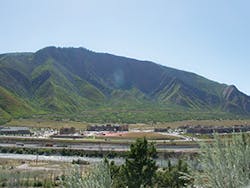
The Glenwood Springs area in September 2010, eight years after the original treatment. Areas where native grasses are dormant appear darker; brighter green areas show brush that has grown back.
Bowman has written previously of the effect of fire severity on soil structure. “High-intensity fires typically have a more severe and longer-lasting impact on soil life than low-intensity fires. While various nutrients can be available during and after a fire, others may be volatilized and lost. Volatilization is temperature dependent and usually affects nitrogen and, to a lesser extent, sulfur, phosphorus, and carbon. At 140 degrees Fahrenheit soil proteins are eliminated; at 257 degrees Fahrenheit soil is sterilized; and at 392 degrees Fahrenheit nitrogen is lost. Research shows that fire destroys between 33% and 100% of soil humus and microorganisms, depending upon the intensity and severity of the fire. High temperatures can also cause the soil to become hydrophobic and impermeable by water, impeding the water penetration necessary to support plant and soil life. This leads to erosion control and revegetation problems unique to burned sites,” he wrote in a white paper describing Biosol, a soil amendment his company markets.
Bringing the hillside back to life with new vegetation as quickly as possible would reduce or eliminate the risk of landslide. The plan to do so would include seeding and soil amendments, but most importantly it would hinge on somehow holding everything together on the steep desiccated slope long enough for the new growth to get a good start.
Glenwood Springs, CO, coal seam fire site
The Bureau of Land Management (BLM) was concerned that dropping material from aircraft might add a factor of disturbance on top of what had already occurred because of the fire, recalls Bowman. However, because of the steep terrain, there really was “no alternative to applying the treatment by air.”
Crews mixed Colorado River water with the mulch and ferried it in multiple flights over the treatment zone. To treat the imperiled 500 acres of the hillside, the aerial team distributed 1,100 pounds of wood mulch per acre, which Bowman says was about half the rate usually applied in fire-restoration scenarios, along with Biosol at a rate of 400 pounds per acre.
Aircraft dropped 50 pounds of seed and 60 pounds of Supertack tackifier per acre to lock it all in place. Ted Stallings’ firm, Aero Tech, completed the 500-acre installation in just seven days.
“The wood-fiber mulch was there to protect the seed and soil from any rains and snow melt; the tackifier is the glue to keep everything in place and keep anything from moving,” says Bowman. “The Biosol has a couple of different qualities. It is a slow-release nitrogen source for revegetation, and it also helps break up the hydrophobic layer that the fire causes.” Biosol also contains chitin, a biological material derived from the shells of crustaceans, that helps counter the hydrophobic layer by “retaining moisture that can be retrieved for use of beneficial microbes and for plant life.”
Bowman says the area had numerous rain events after the treatments, but the application of Biosol “was able to help that water penetrate into the subsoil, so you didn’t just have rain and soil sheeting off and running down the slope. Each of the products had different properties, but they all worked together.”
The BLM kept a close eye on the results. After one year of monitoring, 77% of seed dropped over the Glenwood Springs hillside had germinated. After two years, a BLM official states, “The plots were very difficult to find, despite the fact that they were marked with 18-inch stakes.”
“At one point it looked like someone had Photoshopped green on the mountain; it was amazing,” says Bowman.
He contrasts his results using tackifiers, mulch, and Biosol in combination with seeding to the restoration efforts after another major fire in the Colorado area that took place around the same time. In that instance, he says, an aerial drop of seed and straw mulch alone was used, without tackifiers to hold the soils in place. According to Bowman, germination, which topped out at 35%, proved unsatisfactory, and the aerial seeding process had to be repeated up to six times.
He notes that one of the keys to the Glenwood Springs project’s success was the addition of the Rantec Corp.’s Supertack tackifier to the mix. “Natural seed can bring a place back, but when these things happen we need sediment control for the period before the roots take hold.”
Lindblom remarks, “We are in a current state of learning about how we can coexist with fire. We’ve figured out that fire is going to be here whether we like it or not. We also know that excluding fire from our wild lands is not a great idea. But we don’t really know how to reintroduce it because the landscapes are so altered.”
Just as human sensibilities gravitate towards landscapes contoured by water, so perhaps do they also gravitate towards landscapes carved out by fire. From the perspective of a professional naturalist, says Lindblom, “I find fascination with landscapes that are adapted to fire. I find healthy landscapes that include fire as part of the process attractive, not because of the fire per se, but because of the healthy nature of the diversity of the plants and animals that live in those forests and grasslands.”
The Science For Hydromulch Grows
The Jesusita Fire in Santa Barbara, CA, burned approximately 8,733 acres and destroyed 80 residences. Matt Ingamells, a biologist for Padre Associates, notes, “A third to half of the shrubs were killed even though most of the species were fire adapted, so it was a pretty intense fire.”
In what Ingamells says was an unusual study for his firm, Padre Associates conducted research to evaluate for the county and the Bureau of Land Management whether aerial application of hydromulch would have detrimental effects on the regeneration of the post-fire vegetation and wildlife habitat recovery.
Approximately 1,250 acres of the burned area was treated with aerially applied hydromulch, composed of paper, wood fiber, water, and natural tackifiers. The study selected 11 sample sites at five locations to compare side-by-side control and treatment plots. The control plots were covered with elevated plastic tarps to prevent deposition of aerially applied hydromulch. The mulch mix was a combination of 60% wood fiber and 40% paper fiber held together with water and guar, an organic tackifier. On a per-acre basis, the total weight of material came to 2,000 pounds of paper and wood fiber, with 80 pounds of guar mixed together with 3,500 gallons of water.
About two to three days after the application of the hydromulch, researchers returned to the sites to remove the tarps to allow all the test sites to receive full sun and rain. The control and treatment plots were later sampled using four transects oriented perpendicular to the slope gradient. Overall, 16 0.25-square-meter quadrants were sampled within each 40-square-meter plot. The results of the study indicated that the application of hydromulch did not affect total plant cover in the sample sites over the study period. In addition, the application of hydromulch did not affect non-native plant cover or cause or facilitate weed infestation.
A parallel study reported in 2010 by Santa Barbara County collecting data on sediments at the site showed up to a 100% reduction in erosion from plots treated with hydromulch. When he visited the site, says Ingamells, the thickness of the hydromulch was minimal, “maybe 1/8 inch,” yet it performed as an effective control for erosion. “We’re seeing seedlings of shrubs that are coming in, which should be there. We didn’t look at long-term recovery. But short term, the plants that were there pre-fire were recovering just from [natural] seeding and from crown sprouting.”
