Crissy Field
Snowy plovers are dainty little shorebirds, waders that scurry along beaches on legs that look like twigs. The timid plovers have white underbodies with brown feathers on top. The brown markings around their faces give them a quizzical look, somewhat like owls.
The subspecies western snowy plover nests along beaches, estuaries, rivers, and bays all along the coast of the Pacific Ocean during breeding season, which lasts from March until September. The western snowy plover has been listed as a threatened species since 1993.
In the summer of 2015, this tiny shorebird influenced a major flood control project in San Francisco Bay. And the western snowy plover wasn’t the only species that had to be protected during the project.
The project’s designers and workers had to be mindful always of the overall marine environment and its residents: “Birds, seals, sea lions, fish, whales, porpoises, and dolphins,” says Peter Aguilera, project engineer for the Oakland District of the California Department of Transportation (Caltrans).
“We used an air bubble curtain when we were driving piles to lessen the shock waves by 10%, to keep us below [a level] where aquatic animals would be disturbed [by the hydraulic impact and vibration],” says Aguilera. “We had lookouts in boats, watching a 1,300-foot-radius area around the work site. When animals hear the noises they usually flee, but when they were spotted we had to stop working. Then we had to slowly pick up the noise level.”
He adds, “There were so many constraints on this project.”
Six different regulatory agencies had specific requirements for such matters as the amount of shade, the amount of light, noise levels, and other factors. A major ongoing concern was the turbidity levels in the marine environment, so frequent monitoring was a given.
“We took water samples 300 feet downstream every two hours and 100 feet upstream every two hours. We had to be below 10% of the ambient turbidity in the water,” explains Aguilera.
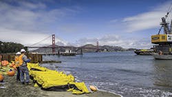
Power Engineering Construction set up a testing lab on Crissy Beach. That close access meant faster results on the quality of the water samples.
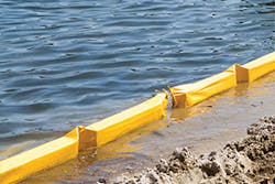
“At Caltrans we have a Department of Water Pollution Control. They did a great job. The original proposal was for the turbidity curtain to encompass the entire length of the pipe. Our Water Pollution Control people ran a computer model and discovered that the curtain would fail because of strong currents,” explains Aguilera.
More model testing showed that a revised design would work. The new design called for a shorter curtain that would extend just past where the pipe came out of the ground.
More anchors needed to be added so that the custom-built curtain would be heavy enough to withstand the current. The curtain chosen was Ruffwater Type III, made by Elastec/American Marine of Carmi, IL.
“We picked the toughest heavy-duty one made. Without fail it did a great job. Two reps from Elastec came and stayed during the [curtain’s] installation. That helped the contractor.”
A constraint that put pressure on everyone involved in the project was the tight time frame. That limitation applied to both design and construction phases of the project.
“We had to begin by May 15, and we had to finish by October 31,” says Aguilera.
“The design work that would normally take two years we did in a six-month period. We had two meetings a day and exchanged 20 or 30 e-mails a day during the design phase. There were many iterations of designs to see. We really brainstormed.”
To save time, “The state furnished pipes, couplings, piles—a lot of things the contractor would normally supply—so we had to get approval for them. Then we were liable for the warranty, not the contractor,” says Aguilera.
With time so scarce, it was fortunate that weather was never a problem. Installation took place during “our better weather time,” he says. “Since California has been in a drought for four years, rain was not a factor.”
Another constraint arose from the project’s National Park Service location and concern for the safety of the visitors it attracts. Once a US Army airfield, Crissy Field is part of San Francisco’s historic military district the Presidio (a major tourist attraction) and offers dramatic views of the bay.
Renovation of the Crissy Field outfall into San Francisco Bay
“We were in a highly populated tourist area. We didn’t want to disturb the public,” says Aguilera.
Staging for the project might have caused problems with the marine environment, but the contractor, Power Engineering Construction, decided not to put equipment and materials on an acre of Crissy Field. That decision saved the time and money that would have been needed to replant the field. Instead, the contractor built an elevated platform on the beach. “That reduced our footprint,” says Aguilera.
Timber mats 1 foot thick were also placed on Crissy Beach for parking of construction equipment. They protected the fragile beach vegetation from damage.
The project came about because flooding was occurring in the Mason Street and Crissy Field areas of San Francisco. The aging IJKL sewer drain and IJKL outfall sewer pipe that carried runoff from the neighborhood into San Francisco Bay was too small.
That inadequate capacity was diminished even further because the end of the outfall was too short. It ended at the water’s edge, so that it was often blocked by sand. When the sand blockages occurred, crews had to remove them.
The outfall’s location was within National Park Service land and control. It was also within a Wildlife Protected Area.
Doyle Drive is close to San Francisco’s famous Golden Gate Bridge, where Caltrans had completed a major renovation project. With the Doyle Drive Roadway Improvement Project, “we created more impervious area, so we were responsible for the added runoff ,” says Aguilera.
“Normally we [as a California state agency] don’t do work on federal lands, but 8% more runoff was going down the outfall. There was more flooding because we had done the big bridge project,” explains Aguilera.
Before work began, a bathymetric survey was done “all over the beach and in the water, so we knew the contours of the bottom of the bay,” says Aguilera.
The existing 42-inch HDPE outfall pipe was expanded to 54 inches. It was extended into the San Francisco Bay so that runoff would be discharged into deeper water. Water depth from the bottom of the bay to the mean high water mark is 15.5 feet.
“From the beginning of the project, 176 feet of pipe were replaced under Crissy Beach, then the pipe was extended 389 feet into the Bay,” says Aguilera.
“We weren’t allowed to use coffer dams because they might entrap an animal,” he says, adding that sheet piles were used to shore up the pipe.
“We drove 24 13-inch HDPE piles to support the pipe, with a slight slope down of 0.19%. They are two feet above the bay’s floor,” explains Aguilera.
The new outfall pipe was designed for a 50-year accretion, meaning that it will stay unblocked for at least 50 years. Buried beneath Crissy Beach, the pipe daylights in San Francisco Bay, but can’t be seen even during the mean low water time, with one exception for safety.
“Except for the last two piles, all of them are submerged. The final two were left eight feet above the mean high-water mark. A ‘Danger—Submerged Pipeline’ sign was posted there to warn kayakers and other boaters,” says Aguilera.
The 13-inch HDPE piles, called SeaPile, are made of 100% recycled plastic by Bedford Technology of Worthington, MN. They varied in length, up to 40 feet. They are each reinforced with eight 1.25-inch fiberglass rods within them.
Aguilera says they are a fairly new type of pile. Their ability to withstand corrosion offers was, of course, a significant advantage in a marine environment.
“The plastic piles were marine friendly, but how to drive them [was a big question]. We used hydraulic impact hammers. We couldn’t use regular diesel hammers. The piles were bending and resounding when they were driven,” says Aguilera.
When Aguilera first learned about the project, he was told that it was just a pipe replacement, the type of work that his department does often. Thinking about the project’s many challenges, he says, “I had no idea of the environmental constraints. We worked around all of those and made it work. We had a good design team and we had a good contractor. That made a difference. It was done within the time limit, within the cost, and within the scope of the project.”
With its multifaceted environmental concerns, this project was, to say the least, complex. Aguilera sums it up by calling the outfall replacement through Crissy Field and San Francisco Bay “the project of a lifetime.”
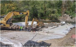
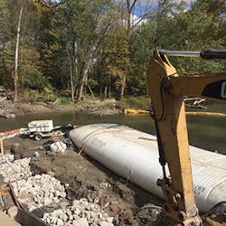
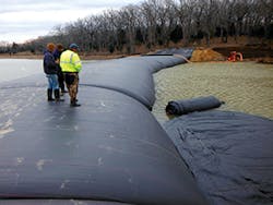
Coffer dams provided a dry work area for pipe installation beneath the River Raisin.
The River Raisin
In southeastern Michigan, the River Raisin runs for more than 130 miles before it flows into Lake Erie. The French named the river “Raisin” (meaning “grape”) for the wild grapes that grew along its banks.
One of the major battles of the War of 1812 took place along the shore of the River Raisin, at a settlement called Frenchtown. That settlement has become the city of Monroe.
About 13 miles from Monroe is the village of Dundee. Just beyond the downtown area residents live along the river, with their backyards allowing access to it for fishing and other recreational activities.
Beneath the river lay “an inverted sanitary sewer siphon crossing with two existing six-inch pipes,” says Joe Siwek, engineer and project designer for Tetra Tech’s Ann Arbor, MI, office.
The system was not adequate to handle wet-weather flow, so it needed to be replaced with new 6-inch and 12-inch inverted siphon pipes. “We had to do a trench repair,” says Chris Goerlich, village engineer for Dundee.
He adds, “The state has its own system that drains the roadway, but a parking lot tied into our sanitary sewer system. During heavy rains our wastewater treatment got inundated. Partially treated and raw sewage were going out to the river.”
The question was how best to accomplish the task, given a tight working area and understandable concerns of Dundee residents. They were worried about damage to their backyards or the river.
“We looked into directional drilling, but the bedrock was too close to the bed of the river. It required six feet of cover from the bottom of the stream to the top of the drill head, coming across,” says Siwek.
He adds, “This was risky, with limited access due to private property. And building a sheet metal dam would have been disruptive to the river environment.”
The village of Dundee already had one easement on private property. A second easement had to be secured before work could begin.
Another task that had to be completed before work began was a wildlife survey, which was done in August 2015 by a biologist. The survey was required because federal and state funds paid for the project.
With a floodplain crossing the River Raisin, there was a good chance that a species of mussels on the federally endangered species list might be present. Fortunately, the mussels were not found in the river and what wildlife was there was relocated about a mile away.
A Triton Type II silt and turbidity curtain was installed downstream from the pipe installation site. Made by Granite Environmental Inc. of Sebastian, FL, this curtain is designed to handle currents up to 1 knot, waves up to 2 feet, and moderate winds.
Siwek says that Dam-It Dams provided design assistance, and two representatives of the company came to help during the installation. He was impressed that the Dam-It Dams coffer dams had such “quickness and ease of installation.”
This was the first time Goerlich had been involved with a project that used a coffer dam. “It worked well. Any seepage that occurred, the pump was able to keep up with it,” he says.
Measuring about 100 feet from bank to bank, the river was about 3.5 feet deep. The coffer dams were therefore 6 feet tall.
The portion of the project that involved the coffer dams took about three weeks in October 2015. The crew started on the south side of the River Raisin, extending two parallel coffer dams about 60 feet out from the river’s bank. Then the two ends were connected with sandbags in a C shape, sealing off the river to provide a dry work site for the pipe installation. The section between the two parallel coffer dams provided a work area about 30 feet wide.
When the first section of pipe had been installed, the dewatering was stopped. Then the coffer dam installation process was repeated from the north side of the river so that the workers could connect the two sections of the new pipe.
The last part of the project was done from November into early December. The siphon structures were installed on either side of the river. Goerlich says that they had to be tested for five consecutive days to be sure they were functioning as designed.
Riprap was installed from the toe to the top of the south river bank. A blend of rye and fescue grasses was seeded to give quick cover where the public would see the bank.
The north bank of the River Raisin contains wetlands. It was seeded with an herbaceous wetland seed mix and loose mulch.
Weather was not a problem during the project. “We had a really dry October,” says Siwek. “There were no significant rain events.”
Goerlich concurs, “We had exceptional weather.”
Looking back on the River Raisin project, Siwek says that its challenges were “just working in such a tight space, working in floodplain, and working on private property. There were constraints on the contractor so the workers didn’t disrupt the environment, too.”
He adds, “It is a scenic area with a lot of public engagement because the property along the river is owned by residents, but a year later they won’t know we were there.”
Long Cove, TX
Coffer dams are usually employed to keep water away from a site so that a pipeline or something else can be installed or repaired beneath the temporarily dry land. In Texas, a coffer dam—actually two coffer dams alongside each other—were used so that the dry land could be removed and more water allowed in.
The reason for the additional water was to create a new cove so that more homes could be built overlooking a waterfront. The new cove is part of Long Cove, a development of luxury second or weekend homes created by the Hampstead Group.
The Long Cove development consists of 1,000 acres along Cedar Creek Lake, the fourth-largest lake in Texas. Located just 75 miles southeast of Dallas, it’s a quick commute for residents of that city, taking only about an hour and 10 minutes.
The two coffer dams used at Long Cove were made by Aqua Dam Inc. of Scotia, CA, and installed on February 23, 2013. The primary Aqua Dam was 16 feet tall and ran for 600 feet. It was backed up by a second dam that was 8 feet tall, both curved into a crescent shape to hold the lake back from the work area.
The smaller coffer dam was installed “because of unanticipated high water, so there would be extra support,” says Matthew Wennerholm, vice president at Aqua Dam.
Enlarging Cedar Creek Lake in Texas
Coffer dams, Wennerholm says, are environmentally friendly and also function as turbidity curtains. “They get the job done for pennies on the dollar compared to traditional dams [of earth or steel].”
“The advantage of using this method is that we could do all of the digging in the dry. We could use smaller equipment and save time. We moved 300,000 cubic yards of dirt out,” says Chris Kelsey, president of The Hampstead Group.
Weather was not a factor on the project. In 2013 the lake was low by several feet. That was an advantage for digging.
The two coffer dams stayed in place for about two months. When the work was finished, “we made the lake bigger by about six acres. We created 2,000 linear feet of shoreline,” says Kelsey.
The development company was able to do this because it holds an individual 404 permit from the US Army Corps of Engineers for the land all around the lake. Kelsey adds that the firm had done all mitigation that was required.
“This was our first of probably three or four of these projects moving back to create that [waterfront] area to be developed. We were balancing the need to create a reasonable slope as we moved away from the water and still preserve as much forest canopy as we could,” explains Kelsey.
He adds, “Initially the slope was way too steep. We came back and softened it, and we took out some more trees.” At the development, he says, “We want to avoid anything steeper than 10% slope as we go back from the lake so there is lots of walkable area. The houses are situated above the water and look down on it. That’s very attractive to buyers. It is really a matter of understanding how people use the lake.”
Even though water depth at Long Cove fluctuates, it generally stays about 9 feet deep. This depth means that residents can always get a boat into the water, mooring it to the floating dock that extends out into the Cedar Creek Lake.
Construction at Long Cove had not required a coffer dam before, but Kelsey says, “It got the job done.” He was pleased that the work “generated almost no turbidity. The little bit of water that seeped through we pumped out, uphill, and it sheet-flowed into a grassy area.”
Coffer dams and turbidity curtains might seem relatively low tech compared to many tools that are used in erosion control work. But as these varied projects show, they perform essential functions and do so cost-effectively.
