Study Shows Natural Bayous Better at Preventing Floods
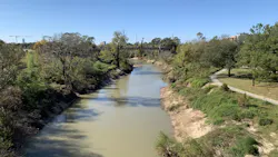
HOUSTON, TX (March 11, 2020) — Two bayous near Houston were the recent subjects of a study by researchers from Rice University's Brown School of Engineering. The Buffalo Bayou, meandering toward downtown Houston from the west, is largely natural, while the Brays Bayou south of the city runs mostly through a concrete channel. Researchers compared the two bayous to determine which is better at preventing floods.
In studying the evolution of flood plains based on Houston's Buffalo and Brays bayous, the researchers associated with Rice's Severe Storm Prediction, Education & Evacuation from Disasters Center determined Buffalo's largely natural form has proven better at absorbing floodwater and preventing it from spilling over into heavily populated areas.
An open-access paper in the Journal of Flood Risk Management details Rice models that show how flood plains have evolved and will evolve over a 70-year span, up to 2040. The researchers used hydrologic and hydraulic models to analyze the two watersheds under 10‐ and 100‐year rainfall scenarios at three points in time: 1970s, 2011, and 2040.
The team of Rice research scientist Andrew Juan, former graduate student Avantika Gori, and associate research scientist Antonia Sebastian found that while the extent of the 10-year flood plain has remained relatively stable along both bayous, the 100-year flood plain shows stark differences.
While the 100-year flood plain model along Buffalo Bayou remained mostly unchanged over the 70-year span, the researchers show recent and potential development along the already densely populated Brays has a significant impact on flooding.
Their models show that urban development in the Brays' watershed, which they expect to grow by 29% from the 1970s through 2040, increased the 100-year flood plain from 10.5 square kilometers in the 1970s to 46.1 square kilometers in 2011. They predict it will rise to 73.3 kilometers in 2040.
According to Juan, some degree of Buffalo Bayou's relative superiority is due to forward-thinking individuals who, starting in the 1960s, protested "channelizing" the bayou as had been done at Brays. That has helped preserve the bayou's natural drainage to contain normally heavy rains that are slower to reach the bayou. Furthermore, banning buildings from the designated setbacks close to the bayou has kept property damage at bay, Juan said.
The flood plains near Brays are of an entirely different character and have changed more significantly since 1970 than those along the Buffalo, Juan said. In the 1970s, the number of residential parcels in the flood plains was comparable. By 2011, the number had increased dramatically for Brays Bayou.
The differences are evident at upstream and downstream watch points along Brays, to the west and east of the flood-prone Meyerland neighborhood, according to the study. Measurements at those points show both 10- and 100-year normalized peak flows nearly doubled between the 1970s and 2011, with larger peak flows occurring when heavy rains inundate the neighborhood.
The study only looked at stormwater runoff into the bayous and its impact on flooding. Minor contributions by underground pipelines, which are sufficient to handle 2- to 5-year floods, and the impact of Barker and Addicks reservoirs that were opened upstream of Buffalo Bayou in the aftermath of Hurricane Harvey, were not considered.
Juan said the researchers realize moving structures away from Brays is highly unlikely, but reconfiguring available open spaces and golf courses to serve as retention ponds when needed could help areas at the epicenter of flooding over the past decade, particularly Meyerland.