Erosion Control & Highways: Building Up
About the author: Bill Hoffmann, P.E., is vice president and senior principal engineer for CTL|Thompson. Hoffmann can be reached at [email protected] or 719.528.8300.
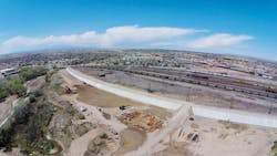
When NorthStar Engineering & Surveying Inc. and CTL|Thompson began rebuilding the 90-year-old, 2.8-mile-long Pueblo Levee along Colorado’s Arkansas River, the engineering team expected to run into challenges. They knew, for example, that extensive repairs would be needed before the 45-ft-tall concrete levee could adequately protect downtown Pueblo, three-quarters of which lies within the floodplain. They also knew that the levee needed upgrades to meet post-Hurricane Katrina certification rules set forth by the Federal Emergency Management Agency’s National Flood Insurance Program.
Three years into the rehabilitation project, it has proven far more challenging and complicated than anyone could have anticipated. The specific considerations encountered on this project spanned every conceivable area, from engineering issues, to navigation of the local political landscape, to working with community groups to achieve an outcome that satisfied everyone involved. The most significant challenges and the engineering solutions are outlined below, but the successful completion of the project required skills and techniques that went well beyond science. Thorough and constant communication at every step of the process was the key to successfully navigating issues both expected and unexpected and required the engineering team to work with artists’ groups, city staff and elected officials, historians, and a team of contractors.
Work Area Constraints
Four major roadways—including Interstate 25, Colorado’s main north-south artery—cross the Arkansas River. Access to the site was limited, with a river on one side and a major railroad switching yard on another side along most of the levee’s length. The eastern third of the work area is situated amid an old residential neighborhood, with homes built up to the toe of the levee.
The levee faces on the wet and dry sides are so steep that the team could not walk on them, let alone drive equipment along the slopes and access the levee’s crest for investigation. Moreover, the top of the levee varied from 4 to 8 ft in width. Through hydraulic evaluation, NorthStar found that the levee could be shortened and still achieve the required level of flood protection. To enable the team to proceed, the existing levee’s height was significantly lowered, widening it at the top to 40 ft.
Soil testing also was a challenge because of the slopes. The team initially had planned to crane a mini-drill rig from the bridges at the top of the levee to drill holes, but feared the light-duty machine might not yield the depths desired. Instead, the team drilled at the crest of the levee using a narrow-track rig that could climb up the face of the slope. Not only did it get the job done, but it also cut the drilling costs by a third.
Other Challenges
The levee’s historical significance created a need for extra approvals. After work had begun, the U.S. Army Corps of Engineers (USACE) alerted the team that the state historic preservation officer would need to approve the project. Although the levee is not on the historic registry, it has historical significance, as the means and methods used to build the original structure were considered “of the time.” NorthStar worked with USACE to achieve signoff on the project.
A funding source for levee improvements also had to be identified. The team assisted the Pueblo Conservancy District board—which added new members during the project period, requiring the team to provide additional education—in reinitiating an assessment to pay for the work. While the district had been collecting money from properties to make improvements, the assessment stopped sometime in the 1950s. When it became obvious that repairs would be needed, the district reinitiated the assessment.
It might go without saying that a lot had changed since the levee was built 90 years ago. As a result of zoning changes, demolition and rebuilds, new ownership, and all the challenges of such a long lifespan, it was difficult to determine an equitable format for the maintenance fund assessments. In the end, all parties involved recognized the benefits of the repair and the conservancy district enacted a three-tiered assessment approach, changing the boundaries from the floodplain itself to all of Pueblo County.
Additionally, the levee is a work of art and a Guinness World Record holder for the world’s largest outdoor mural. While city officials and stakeholders recognized the levee’s function, artists in the community saw its form—the levee was the canvas for the mural, created by contributions from thousands of artists over four decades. When the local artist community learned that some of its work would be destroyed, its members were understandably upset. In moving forward on this engineering project, the team held ongoing meetings with the artist community to understand its concerns and try to find a reasonable solution. Unfortunately, some of the original work was destroyed, but as the team has moved forward, they have created a way for artists to safely access the site, and artists are well on their way to designing a new work of art that beautifies the community and gives them a showcase for their work.
The engineering team has three to four years of work ahead, but with open communication and an experienced team, they expect to glean an abundance of additional insights by the time the project is deemed complete; each substantial challenge can result in an opportunity to learn and consider a new approach.
Download: Here