Located approximately 45 miles from Detroit, MI, Ann Arbor receives about 35 inches of precipitation per year. Much of this precipitation falls in the spring, followed by periods of extreme heat and minimal rain in the summer.
Ann Arbor contains several creeksheds that are tributaries of the Huron River: Traver, Malletts, Millers, Honey, Swift Run, and Flemming. Together, these creeksheds comprise part of the Huron River watershed.
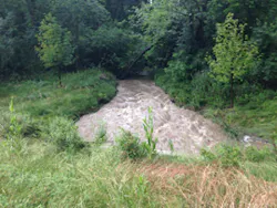
The Huron River runs for 136 miles and drains an area of about 910 square miles. The watershed supplies water to the city. It also provides opportunities for recreational enjoyment, wildlife habitat, and hydropower.
“I think of the river as our main street of our culture. It’s the driver of cultural, economic, and recreational opportunities,” says Laura Rubin, executive director of the Huron River Watershed Council.
The Huron River Watershed Council is responsible for monitoring, maintaining, and improving the quality of the watershed. The council has plenty of work, because some portions of the watershed have been designated by EPA as impaired.
“We do a lot of testing and monitoring and quite a bit of outreach,” says Rubin. “We have 73 units of government that we work with.”
The city of Ann Arbor maintains roughly 363 miles of sanitary sewer pipes–more than two-thirds of which were built in the 1960s or earlier. Some of the older pipes are made of vitreous clay, which increases the chances of tree roots infiltrating and blockages developing.
About 13% of the pipes in use today were built in the 1910s, and another 14% were built in the ’20s, ’30s, and ’40s. Only about 3 to 4% were built since the year 2000, while 25% were put in place in the 1970s, ’80s, and ’90s.
“Fifty years ago pipes were smaller–that was the standard then. Now the city has more impervious surface. Those older pipes would not meet the standard of what’s required now. We have some pipes that are 80 years old and their integrity is fine, but capacity might be an issue,” says Jennifer Lawson, Ann Arbor’s water quality manager.
City crews clean and inspect the pipes on a seven-year rotation, but updating the system to keep up with modern standards while ensuring it continues to function properly is a major challenge.
Ann Arbor’s total stormwater system consists of 540 miles of pipes and 23,000 inlets and catch basins. The overall system is managed by the city, Washtenaw County, and the University of Michigan.
“We have a $6 million annual budget. Three and a half to four million is dedicated to capital improvements,” says Lawson. “We plan capital projects six years out and update our plan every two years.”
Like many cities with aging infrastructure, Ann Arbor has been coping with flooding for years. Residents in some neighborhoods have complained repeatedly. Things have been so bad in the Lansdowne neighborhood that residents there created a blog to which they post complaints.
Stormwater officials decided that they needed to take a broader approach to managing runoff, particularly after heavy rain events. They also wanted to involve the community, raise residents’ awareness of stormwater issues, and be sure they were making the wisest investments in gray and green stormwater infrastructure.
A major part of that broad approach is getting a more accurate, more detailed picture of how stormwater actually behaves in Ann Arbor. The city’s 2012–15 Stormwater Model Calibration and Analysis Project is the camera that will take that picture.
The project is also known as the Stormwater Management Model (SWMM). It will refine the stormwater model that the city developed in 2008.
The 2008 model included a detailed inventory of pipes, manholes, catch basins, open-channel cross-sections, and detention basins with a graphic information system (GIS). This base model was functional, but was not calibrated on a basis of actual local storm data. Additional data were collected to determine if the assumptions used in the 2008 model remain accurate.
The SWMM project began in the fall of 2012 with the creation of model updates. From winter 2012 to 2013, the city held neighborhood meetings and made preliminary calibrations. From spring to fall 2013, data were collected by staff and volunteers.
Final calibration was done from the end of the collection period through the late spring of 2014. The final model analysis is scheduled to be completed sometime later this summer. The CDM Smith engineering firm, with Jay Zawacki as lead project engineer, is partnering with the city to do the technical aspects of modeling and calibration.
“We are going to use the calibrated SWMM model to evaluate the 100-year floodplain and make a comparison to existing FEMA flood maps,” says Zawacki. “The city wants to make sure that the FEMA floodplain is accurate, because it has significant ramifications for current property owners and for planning and development of floodplain areas.”
Lawson describes the project as “a technical project, taking our digital framework of our stormwater system and plugging it into our hydrologic model.”
Zawacki says the project’s biggest challenge “is building the overland flow structure into the model. Some of the most critical questions that we need to answer are dependent on correctly representing surface stormwater behavior during large storm events. Our expectation is that the model will be able to predict flooding depths in historical flooding locations and incorporate the available surface contours from the DTM to predict where flows are conveyed along streets and other overland flow pathways.”
The project’s first phase was very time consuming, Lawson says. “We were building a framework, a wire framework of our system that was incorporated into GIS. Ann Arbor uses GIS to manage all of our stormwater system. It’s inventoried and documented down to taking photos inside of individual manholes.”
However, Zawacki says the complex project has gone more smoothly than it might have. “We worked with the city to establish a straightforward scope and schedule that allows us to work sequentially through the tasks, which keeps the project team focused on the current activities and objectives.”
He adds, “It also helps a great deal that we have an excellent team, especially with the city, made up of people who understand the importance of stormwater management and are committed to a successful project.”
To collect the required data for phase two, the SWMM project took in readings from flow monitors and rain gauges. It relied extensively on visual observations and firsthand notes of stormwater situations, made during rain events and afterward.
Ann Arbor residents are making those visual observations and collecting data on stormwater situations of most concern in their neighborhoods. The city has recruited residents to help in one or more ways. They can send in their observations about particular stormwater situations or attend public meetings. Six neighborhood meetings were held in areas where known stormwater problems occur. Notifications of the meetings were sent to all residents who live within 500 feet of these “stormwater corners.”
Lawson says these meetings “were opportunities for residents to tell us where flooding occurs. There were some places we didn’t know about. People didn’t complain about them, or they didn’t show up on our model.”
An Online Community Survey
Another way for the city to learn about residents’ concerns and problems with stormwater was through an online community survey, which ran from January to August 2013. Promoted at public meetings and on the SWMM website, the survey drew 295 responses.
One of the survey’s 10 questions asked if residents had ever experienced flooding in their home or neighborhood. Seventy-seven percent of the respondents said yes. Each of four sites for that flooding (respondent’s home or yard, neighbor’s yard, neighborhood street) received at least 57% affirmative answers.
For those respondents who indicated that flooding occurs in neighborhood streets, more than 64% agreed with the survey’s description that “the street fills with water, which flows over the curbs onto sidewalks/yards.”
Answering the survey’s question about the length of time that water remains in yards, 61% of respondents said for several hours after a storm. Forty-four percent indicated that runoff is still there several days after a storm.
Flood triggers included a large amount of rain in only a few hours’ time (more than 86% of respondents) and steady rain falling for a day or more (almost 63%). Several storms coming within the span of a week or so caused less flooding (42% of respondents).
The survey question on which season has the heaviest flooding in Ann Arbor drew the most unified response. More than 93% of the respondents chose spring.
The survey included an open-ended question asking for other locations, such as golf courses or shopping centers, at which respondents had seen flooding. Respondents were also given the opportunity to include additional comments related to the other questions.
Toward public education and involvement, survey respondents were asked for their contact information (and promised it would be kept confidential). They also were asked if they wanted to have their names added to the city’s e-mail list to receive news about the stormwater project. Sixty-six percent opted to receive the e-mail updates.
Information from the survey was entered into the Citizen Request System, the online GPS-linked tracking system of complaints about flooding, traffic, and other problems reported by residents in Ann Arbor. This was done to record specific locations and also to make the respondents’ comments searchable.
Survey responses were grouped into areas with frequent report of flooding to provide validation of model predictions. Respondents’ comments will be used in matching the desired level of service with planning for future stormwater infrastructure, both green and gray.
Citizen Storm Corps and SWAG
Ann Arbor residents who were willing to be more involved could join the Citizen Storm Corps or participate in the Stormwater Advisory Group (SWAG). Summaries of the group’s meetings were posted on the city government website.
The SWAG includes citizens, stormwater professionals, and other interested stakeholders. Its primary purpose is to advise the city on various technical aspects of the SWMM project, such as identifying locations where stormwater observations should be made.
At the end of the project the SWAG will suggest possible changes to the stormwater system that are indicated by the findings of the SWMM. The group meets at least quarterly. Records of its past meetings are online for anyone to read.
Citizen Storm Corps volunteers were advised that they would probably be called on one to three times over the several years of the project, though they could participate more often if they had the time to do so. Their assignment was to visit one or more of the large event data gathering (LEDG) locations during or immediately after significant rainfall.
The photographs participants took and the observations they noted were then sent–electronically or by postal mail–to the city. While orientation sessions were held for the volunteers, they were told that if they could take photographs or use a map they had the skills required to assist with the SWMM project.
There were 42 LEDG locations. They included a dam, busy commercial intersections, residential/suburban intersections, a golf course, a recreation center, and specific points along various creeks.
Each LEDG location had its own specific reporting form for its assigned Storm Corps observer(s) to download or print out for each particular storm event. Some questions were on all of the forms, asking if the observers saw such details as water flowing through the catch basins, debris on the catch basins, and indications that a sanitary sewer had overflowed.
Observers were asked to mark the edges of high water with stakes. On their forms they noted the residential address (or locations as specific as possible) for the extension of the flooding in each direction.
To ensure consistency and clarity in reporting, each LEDG location’s form had at least two photographs with clear descriptions of where they were taken and what directions they were facing. Observers were asked to orient their cameras to the same views and take photographs of the same scene after the new rain event.
The observers were encouraged to include any other photographs they wished, but the pictures of the exact same location, taken from the same angle, of each rain event will be incredibly helpful in discerning stormwater behavior and allocating the resources to manage it.
The last section of each LEDG report form asked for a written description of water depth, using reference points on the photos. Observers also had to mark the runoff’s rough boundaries on a copy of an aerial photo of the site.
All of this involvement by Ann Arbor residents is serving to help them understand stormwater behavior and effective strategies to deal with it. They are gaining not only information in general, but also knowledge of specific stormwater problems and solutions for their neighborhoods.
Lawson admits to being surprised by the number of people who have an interest in stormwater infrastructure or stormwater management. “They truly want to be a part of bettering their community.”
Zawacki agrees. “The levels of interest and understanding about stormwater among the public have surprised me. The public involvement process with stormwater modeling has been much easier than it typically is with sanitary sewer projects or other civil/environmental work.”
He adds, “I think the city’s ongoing stormwater programs, along with visible outreach activities by groups like the Huron River Watershed Council, have really worked to raise public awareness of the importance of stormwater management.”
Rubin says that all of this public outreach and citizen involvement has benefitted the Huron River Watershed Council with “definitely more support and a greater understanding of stormwater issues. A citizens’ corps, I think, is always a good idea.”
Allocating Capital Improvement Funds
When the SWMM calibration stage is completed Ann Arbor’s stormwater officials will have a detailed picture of stormwater’s impact on their city. They will be able to spend limited municipal funds on stormwater projects that will bring the biggest improvement, and they’ll have more support from the public for their efforts.
Lawson sees the model as “a great tool” and “a smarter way to do our forecasting for capital improvements.”
Lawson’s advice to other stormwater officials who are considering such a detailed stormwater model project is to “include the public in the process, even to empower them as citizen-scientists.”
She adds, “There’s a misconception among the public that stormwater infrastructure is built to handle every last drop of water. That’s just not possible or financially feasible. Involving the public helps you justify the decisions you make and gives you a perspective you wouldn’t have.”
Some of the stormwater projects to alleviate flooding will involve gray infrastructure, but green infrastructure will also be used. Ann Arbor has, of course, already installed some green infrastructure projects to manage stormwater.
“We’ve been incorporating green infrastructure into projects for some time,” says Lawson. “All city streets are required to infiltrate the first inch of stormwater.”
Mary Beth Doyle Park is the largest park in Ann Arbor, located along Malletts Creek (a tributary of the Huron River). From 2006 to 2008, the park was closed for redesign and construction aimed at improving its capacity to store, infiltrate, and treat stormwater. The project included a redesign of the 15-acre impoundment, including removing 31,000 cubic yards of contaminated sediment, building a temporary stream to construct a sediment forebay, building an embankment dam and weirs, modifying the outlet structure, and landscaping.
A 12-acre created mitigation wetland within a larger wetlands preserve included the planting of 25 species of native plants. Features to improve public access to the water include pedestrian pathways, educational signage, and a bridge over the pond.
Although extensive pre- and post-construction monitoring data are not available, research suggests the project has improved water quality and stormwater management in the area. The wetlands preserve, for example, can hold up to 15 million gallons of water at once, and about 1.5 billion gallons of water flow through it each year. Combined, the pond and wetlands reserve remove about 1,000 pounds of phosphorous that would otherwise flow into Malletts Creek per year (or about 25% of all the phosphorous). Flows in Malletts Creek are more consistent post-construction, and are less susceptible to sudden spikes after large storm events than they were.
The Easy Street Pavement Rehabilitation Project was completed in late 2007. The project had several objectives, including improving stormwater management, calming traffic, increasing pedestrian access, and improving landscaping.
The project was designed to reduce stormwater runoff by replacing 3 to 3.5 feet of existing asphalt along outer edges of the street with porous pavers. The porous pavers can infiltrate 4 to 8 inches of water per hour.
The street is slightly sloped along its entire length, with its crown running along the center. The project was designed to direct stormwater from the street toward the pervious pavers and five swales along the side of the street
The green roof atop Ann Arbor’s renovated Municipal Center reduces the post-redevelopment site runoff by 87.5%, or 59,300 gallons, for a one-year, 24-hour design storm and by 87.3%, or 76,200 gallons, for a two-year, 24-hour design storm. It also provides a recreational area for city employees and reduces annual heating and cooling costs by about $1,000.
Completed in 2011, the project also includes all native plants, and permeable paving in parking lots and pedestrian areas. Gravel beneath the paving allows for infiltration. A cistern reclaims stormwater for use in an art sculpture fountain.
The Millers Creek Rainwater project was created to see if some small best management practices (BMPs) could be combined to stabilize the water flow in a sometimes flashy, very disturbed stream located in a residential area.
The Huron River Watershed Council built two community rain gardens, enlarged a detention pond, helped design four private residential rain gardens, and gave rain barrels to residents. In addition to these BMPs, the council conducted an intensive educational campaign to teach residents about their impact on the creek and stormwater strategies.
Detailed analysis after completion of the project showed that peak flows were reduced by 40%. The neighborhood gained a walkable rain garden area, streambanks were stabilized, and the numbers of macroinvertebrates increased.
Rain gardens such as those near the headquarters of Millers Creek work well in Ann Arbor because the deep roots of their native plants can absorb runoff from the heaviest rains that fall mostly in the spring. Native plants are also tolerant of Ann Arbor’s hot, dry summers.
Rubin notes that Ann Arbor is fortunate to have a stormwater utility. “Stormwater utilities are very unusual in Michigan. About 15 years ago, in a famous decision in Lansing [state court], the court shot down a stormwater utility. Ann Arbor put a lot of time and money into its stormwater utility, to make it defensible in court.”
A result of having the stormwater utility, she adds, is that “Ann Arbor is able to do more by far than other communities in our watershed.”
The Huron River Watershed Council held three forums on increasing green infrastructure in Ann Arbor during the summer of 2013. Topics discussed included overcoming the barriers, funding green infrastructure, and operation and maintenance of green infrastructure features. Attendees included state to local entities: the Michigan Department of Environmental Quality, Washtenaw County Water Resource Commissioner and Road Commission, the City of Ann Arbor, the Village of Dexter, Pittsfield Township, and other municipalities were involved.
As with Milwaukee, WI; Los Angeles, CA; and other cities, Ann Arbor is making an effort to preserve open space and acquire the development rights that will keep land open. This practice helps manage stormwater onsite.
Ann Arbor’s Greenbelt Initiative began in November 2003, when the city’s residents voted overwhelmingly in favor of the Open Space and Parkland Preservation Millage, commonly referred to as the Greenbelt Millage. The Greenbelt Millage involves a 30-year, 0.5-million tax levies.
A portion of the money is used to purchase new city parkland, and a portion is used to protect agricultural and open space land outside the city, within the Greenbelt District. The purpose of the Greenbelt Program is to protect working farmland and natural areas and protect land along the Huron River and its tributaries.
Funding to purchase development rights comes mainly from the US Department of Agriculture’s Farm and Ranchlands Protection Program. The Greenbelt Advisory Commission also partners with several locally funded programs.
Ginny Trocchio, the project director, says that the Greenbelt has expended funds to protect 35 working farms through the purchase of development rights and four open space parks or nature preserves. Collectively, these properties comprise over 4,200 acres of protected land around Ann Arbor.