Issues With Clay? No Way!
This article discusses a novel approach of using a sand lens to convey the stored volume of runoff gradually into the deeper layers of the soil, or to the water table, to overcome some of the design challenges resulting from clayey soils.
Background
The Lynnhaven River Basin, which belongs to Chesapeake Bay watershed, is located in the northern portion of the city of Virginia Beach, VA. It covers an area of 64 square miles. A comprehensive stormwater management (SWM) plan for Watershed 04 (WS04) of the Lynnhaven River Basin was developed by the city of Virginia Beach. WS04 is located at the headwaters of the Western Branch of the Lynnhaven River and most notably includes the Thalia Creek drainage basin. WS04 encompasses an area of 12.5 square miles. In developing the comprehensive SWM plan, the city assessed sites in the watershed according to the methodologies described in the Center for Watershed Protection Unified Subwatershed and Site Reconnaissance (USSR) and Unified Stream Assessment manuals as modified for local conditions. The city performed a detailed field assessment following the USSR manual. The analysis of the field data and of priority watersheds resulted in a list of potential remediation/restoration projects.
The pollutants of concern (POC) considered in the Chesapeake Bay total maximum daily load development are total nitrogen, total phosphorus, and sediment or total suspended solids. The SWM plan recommends a combination of structural and nonstructural BMPs to improve water quality (or reduce POC) in the Thalia Creek. A total of 18 structural BMP retrofit projects were recommended for WS04. All recommended projects were selected based on ownership, access and constructability, load reductions (pounds), total estimated cost, and best engineering judgment. The recommended projects include a bioswale and vegetated buffer, streambank stabilization, bioretention basins, permeable pavement, and regrading and vegetation.
One of the recommended projects is to treat the runoff from the highly impervious parking lot at the Princess Anne High School. The entire parking lot is paved and measures approximately 6.0 acres. The runoff from this lot flows over an existing grass surface and is conveyed into a ditch before it outfalls into Thalia Creek.
Conventional SWM techniques employ efficient drainage system designs with “end-of-pipe” treatment options (stormwater detention/retention basins). This approach drastically changes the hydrological behavior of the natural systems by increasing the volume of stormwater runoff, sediment, and nutrient loadings to the receiving water bodies.
In LID BMPs, reducing the volume of stormwater runoff generated is principally achieved using infiltration techniques. However, significant problems arise when the project site is overlain by highly impervious clayey soils. Using perforated underdrains to drain infiltrated runoff in LID BMPs is one option, and is often a preferred choice when clayey soils are encountered. Unfortunately, it comes at the cost of reduction in the phosphorus removal rate.
The city of Virginia Beach contracted AECOM to design a water-quality BMP for the Princess Anne High School parking lot. The project site was ideal as a candidate for a structural BMP retrofit in several respects; the site is publicly owned, offers ease of access, is an older school site (1954) with no onsite stormwater treatment practice, has a highly impervious parking lot, and presents an opportunity to introduce and educate the public on LID BMP practices.
Project Objectives
The project objectives are threefold:
- Improve water quality by reducing nutrient loads such as nitrogen, phosphorus, and sediment
- Minimize effective imperviousness to create functional site drainage
- Reduce the volume of stormwater runoff using infiltration techniques
Selection of BMP
The project objectives made the selection of a water-quality BMP challenging. Incorporating a traditional BMP, such as a wet pond/dry detention basin treating all of the flows generated from the paved surfaces, was not feasible. Further, such large-scale approaches to stormwater treatment focus on controlling the rate of runoff, but not the quality or volume of runoff. LID techniques work alongside traditional approaches to manage runoff at its source to improve stormwater quality, minimize effective imperviousness, and reduce the runoff volume.
The placement of LID BMPs such as bioretention basins at strategic locations was considered. However, this BMP would minimize the effective imperviousness at the cost of losing functional use of the parking lot.
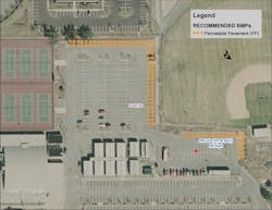
Because the parking lot is more than 6.0 acres, replacing the entire lot with permeable pavers was cost prohibitive. Moreover, permeable pavers are not designed for high traffic volumes. After a thorough analysis of the site, AECOM settled on replacing a small section of the rear parking lot closer to the ball fields, used primarily as an overflow parking area, with permeable pavers (Figure 1). This BMP resulted in an estimated load reduction of 2.99 pounds per year of total phosphorus. Because this LID BMP involves infiltration, it results in a net reduction in the runoff volume, and the functional use of the parking lot is maintained while reducing the impervious area.
Design of LID BMP
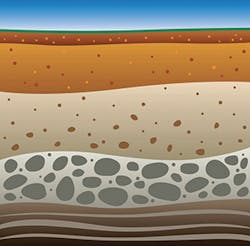
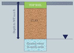
The first step in the design process was to determine subsurface soil and groundwater conditions. Two 15-foot-deep standard penetration test borings were drilled within the area proposed for permeable pavers. A temporary groundwater monitoring well was installed at each BMP boring location. Also, in-situ soil permeability tests were performed at each BMP boring location. Figure 2 shows the general soil profile at the project site. Boring logs classified soils as predominantly clay (97% fines) at both locations to a depth of 10 feet below ground surface and sandy soils from 10 to 15 feet. The initial groundwater table was encountered at depths ranging from 10 to 11 feet below ground surface. Infiltration tests attempted at each BMP boring location at a depth of 3 feet below ground surface and a depth of approximately 1 foot above the 24-hour groundwater table were ineffective because of impermeable clay soils at depths 0.33 foot to 10 feet below ground surface. Consequently, an infiltration rate of less than 1.0 x 10⁻⁶ centimeters per second was assumed for these cohesive soils.
Design Challenges
Infiltration was ineffective in subsurface soils because the stormwater would not drain past the impermeable clay layer. In some areas, such as low-lying coastal plains, lateral underdrains may not be feasible if there are no nearby storm structures or outfalls that are deep enough to daylight the underdrains. Using perforated underdrains to drain infiltrated runoff is one option in LID BMPs, and is often a preferred choice when clayey soils are encountered. Unfortunately, it comes at the cost of a reduction in the phosphorus removal rate. At this site, placement of lateral underdrains to effectively remove infiltrated water through permeable pavers was not feasible because the outfall was too shallow. The designers had to be more creative in finding a solution to the design challenge given the site constraint.
Innovative LID BMP
The objectives were to identify an effective LID BMP practice to meet water-quality requirements, minimize imperviousness, and reduce stormwater runoff despite the design challenges encountered. AECOM designed an innovative water-quality BMP using permeable interlocking concrete pavers. Out-of-the-box thinking was employed to use of a vertical underdrain instead of lateral underdrains. Vertical underdrains are more common in other parts of the world. The vertical underdrain was better suited at the site because the initial groundwater table was encountered at depths ranging from 10 to 11 feet below ground surface. Borings logs indicated sandy soils 10 to 15 feet below ground surface. The challenge was to size the vertical underdrain and the number of vertical underdrains required to effectively convey the stored volume of runoff from the reservoir underneath the permeable pavers (plan area of permeable pavers is 582 feet by 20 feet, or 11,640 square feet) to sandy layers of the soil.
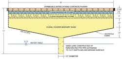
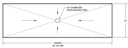
The Virginia BMP Clearinghouse standards and specifications for permeable pavement were used in the design. The subgrade of the permeable concrete pavers consists of a 3-inch bedding stone layer and a reservoir with 6 inches of stone overlain on 24 inches of sand. The subgrade reservoir is designed to provide adequate storage volume for a 1-inch target rainfall event. A 12-inch vertical perforated pipe filled with sand, also known as a sand lens, is used to transport stormwater volume held in the reservoir into the water table within 72 hours. Figure 3 shows the cross section details of the permeable paver design, and Figure 4 shows the plan view. The bottom of the subgrade is sloped to convey runoff down into the 12-inch-diameter perforated pipe. To effectively convey the stored volume of runoff into deeper sandy layers, seven sand lenses were required.
Concluding Remarks
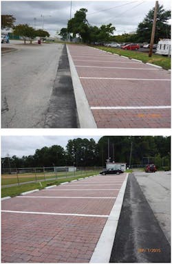
The project was successfully executed in the summer of 2015 (Figure 5). The total area of permeable pavers is 11,640 square feet at a cost of $238,000, or approximately $20 per square foot. The cost per pound of phosphorus removed is significantly high, approximately $80,000. One preventative maintenance task recommended for the Princess Anne High School permeable pavers is vacuum sweeping once or twice a year. Dry weather sweeping in the spring months is important and should not use water spray, because spraying may lead to subsurface clogging. However, the project is still considered a success for the following reasons:
- For highly impermeable soils, identifying a BMP that uses infiltration practices is a challenge. The novel approach of using a sand lens to convey the stored volume gradually into the deeper layers of the soil, or to a water table, provided a maintenance-free LID BMP that has operated successfully for one year.
- The project retained functional use of the parking lot while minimizing the effective imperviousness of the site.
- The city of Virginia Beach has always led by example. This is one such project that the city would like to showcase.