Pierce County’s Surface Water Management (SWM) division is charged with maintaining both the natural surface water systems and the stormwater collection and conveyance infrastructure within its unincorporated 1,800-square-mile service area (population 380,000). These areas include an impressive variability in landscapes: from glacial streams of Mt. Rainier to fertile farmlands of the Puyallup River valley to protected shellfish zones on Puget Sound shorelines, and across stretches of highly urbanized spaces in between.
Part of SWM’s responsibility is the management of the county’s Phase I National Pollutant Discharge Elimination System (NPDES) municipal stormwater permit, which covers discharges from the municipal separate storm sewer system (MS4) that Pierce County owns and operates. Pierce County is the second-largest Phase I NPDES Municipal Stormwater permittee within the state of Washington. Furthermore, according to US Census figures, Pierce County had the largest net increase of people moving from a different county within the US in 2016 (change 2015–2016: 6,824).
NPDES (Section 402 of the federal Clean Water Act) is a federal program that requires the issuance of permits for the discharge of pollutants into the nation’s waterways. For Pierce County, EPA delegates this undertaking to the state agency, the Washington Department of Ecology (Ecology). The current permit is a “general permit” that Ecology issued to Pierce County and other western Washington Phase I jurisdictions (Snohomish, King, and Clark counties and the cities of Tacoma and Seattle). The five-year permit has an effective date of August 2013 and will expire July 31, 2018.
The Illicit Connections and Illicit Discharge Detection and Elimination (IDDE) section of the permit (S5.C.8) requires the county to implement an ongoing program designed to prevent, detect, characterize, trace, and eliminate illicit connections and illicit discharges into the MS4. Pierce County has established the following components to comply with the IDDE section of the permit:
- Procedures for reporting and correcting or removing illicit connections, spills, and other illicit discharges when they are suspected or identified
- A program for detecting and identifying illicit connections and non-stormwater discharges to the MS4
- Response to illicit connections and illicit discharges including spills
- A program to investigate and respond to spills or improper disposal into the MS4
SWM personnel respond to illicit stormwater discharge reports through various modes of notification, including, but not limited to, an IDDE telephone hotline, email, internal county staff communication, after-hours reports, in-person communication, personal observation, and inspection program referrals. Additionally, permit-required field screening (S5.C.8.c) involves methods for identifying potential sources. IDDE incidents that occur in the right of way are generally responded to by the Pierce County Road Operations Division.
All IDDE incidents are assigned to investigators or responders for assessment, follow-up, and possible mitigation. IDDE incident reporting and recordkeeping utilizes Public Works Road Management System (RMS). RMS is a web-based work management system that prepares both internal and external requests for action (RFAs). The RFA system was originally used by Road Operations and adapted for IDDE use beginning in 2012. It contains limited functions that allow incident tracking with assignment of unique identification numbers, narrative observations, and attachment of documents and photos. Unfortunately, the RFA system is far from perfect: It is not user friendly, the IDDE data are not comprehensive, and recorded information is difficult to retrieve or export. Therefore, early in this analysis, it became obvious that using the RFA system alone for IDDE actions and activities could not improve the county’s stormwater adaptive management process. Consequently, Pierce County SWM began to seek ways to increase the functionality and meaning of these stored IDDE records.
Study Details
The Five-Year Pierce County IDDE Study began with systematic vetting of all historical RFA incident report narratives that were recorded from 2012 to 2016. A subsequent review of these reports found the IDDE incident information (limited to date, unique identification number, and inspector name) to be incomplete for implementing a meaningful analysis. Accordingly, incident categories were expanded fourfold to capture additional critical information and were then exported to a separate database. Added elements included:
- number of days to begin investigations
- reported pollutants
- verified pollutants
- stormwater or surface water impacts
- drainage basins
- TMDL areas
- shellfish protection areas
- referral actions
- enforcement actions
- land use
- number of days to incident resolution
The newly clarified records now formed a single, comprehensive, and functional Excel pivot table database that was used to classify, sort, count, total, average, and analyze more than 1,000 separate IDDE incidents.
This article does not describe all of the IDDE study components, but it does concentrate on the significant outcomes. Additionally, the analysis offers a unique opportunity to compare and contrast IDDE events that occurred across both urban and rural Pierce County settings during the study period. The five-year analysis (spanning roughly the same duration as the current permit) yielded a number of key findings, including 1) an identification of stormwater IDDE pollutants of concern; 2) a demonstration of IDDE incident frequency within drainage basins; 3) the establishment of temporal trends; 4) a correlation between IDDE incidents, percent impervious coverage, and land-use categories; and 5) measurable characteristics of IDDE operations and functions.
Summary of Results
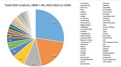
An analysis of IDDE data illustrates the wide variation of incident types (57 different pollutants) documented during the five-year study period (Figure 1), ranging from petroleum to sewage to food waste to soap. The largest incident fraction classified was “unconfirmed” (27%). These were IDDE incidents initially reported as having a visual stormwater pollution component (e.g., an observed petroleum-like sheen, foamy water, or sewage odor). Unfortunately, for unknown reasons, the presence of pollution associated with unconfirmed incidents was never positively identified in the field by staff during follow-up investigations (contrary to initial reporting). The significant percentage of unconfirmed reports is concerning when we consider that Pierce County is large (1,806 square miles), and response times may take up to half an hour due to long travel distances to the reported locations.
Four percent of the IDDE data was classified as “unspecified.” Unspecified incidents reflect sources of obvious pollution where constituents could not be clearly identified (e.g., an unknown milky substance observed in a stormwater catch basin).
There are no clear answers as to why there was such a large number of unconfirmed reports. The data indicate that the percentage is fairly steady, with a slight decrease over time. A decrease would be a positive finding, suggesting that the IDDE program’s efficiency is improving. The reasons for improvement may include enhanced notification, better employee training, and better IDDE incident management (due to the acquisition of more experience over time by field personnel). This information is helpful in strengthening our goal to continually implement improvements (when possible) to increase the odds of successfully identifying and addressing valid stormwater pollution reports.
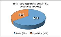
Figure 2 depicts the percentage of IDDE investigations distributed between incidents investigated by SWM personnel (65%, outside the right of way) and those incidents responded to by Road Operations field crews (35%, inside the right of way). Additional analysis indicates that this proportion remained steady throughout the study period.
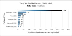
For better management and understanding of the data, all distinct petroleum-containing incidents (e.g., diesel, gasoline, hydraulic fluid) were combined into one pollutant type grouping: total petroleum. Figure 3 illustrates the top 10 verified pollutants documented during the study period, with total petroleum contamination (54%) comprising the largest fraction of IDDE incidents recorded.
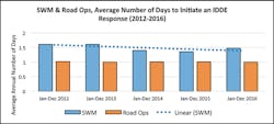
One of the requirements outlined in the county’s NPDES permit for IDDE (S5.C.8d.iv.2) is that any complaint, report, or monitoring information that indicates a potential illicit discharge is to be investigated (or referred to the appropriate agency with authority to act) within seven days, on average (response time). An analysis of 2012–2016 IDDE data demonstrates that the county has met this performance measure, with an average response time of 1.3 days. Data analysis also shows that the average number of days to resolve IDDE incidents is approximately nine days on average. Both performance measures indicate improvement (i.e., more rapid response and resolution time), which are useful findings for the program. All metrics described above enable Pierce County to establish baseline metrics to track future program management progress and effectiveness.
The analysis also allows both SWM and Road Operations response times to be teased out of the total IDDE incident value. Due to the importance of traffic safety, spills in the right of way require immediate attention; the IDDE study demonstrates that it takes Road Ops approximately one day on average to complete an incident response within its purview (Figure 4). The data also indicate a decreasing trend for SWM responses.
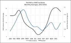
The reason the nation has stormwater permits is because stormwater runoff can transport pollutants into receiving waters. Therefore, an examination of these data attempted to associate rainfall with IDDE incidents. That is, do we see an increase in IDDE incidents during rain events? To answer this, rainfall monthly averages (McChord Airforce Base gauge) were plotted in three different ways:
- Against separate groupings of IDDE pollutants deemed likely to be either affected by, or transported by, precipitation: petroleum (n=392), sediment (n=74), and private septic (n=21)
- Against a combination of these three IDDE pollutants (n=487).
- Against all IDDE incidents (n=1,030) recorded during the study period
Visually, the rainfall graph displays the telltale annual western Washington late-summer drought (almost no precipitation in July and August), and the rainfall trend corresponds well with a lower occurrence of IDDE incidents during this two-month period.
The correlation appears even stronger for rainfall plotted against total IDDE incidents (Figure 5). These data suggest that the number of reported IDDE incidents is greater during wet weather; it clearly shows that precipitation helps to increase the visual presence of illicit discharges. For example, a small petroleum spill on wet pavement during a precipitation event will typically spread into a much larger rainbow sheen and can travel great distances down curb lines or ditches, where it tends to generate multiple water pollution complaints. Drips of the same magnitude on dry pavement during the summer months usually do not garner an equivalent public reaction.
Of note was the unexpected springtime (March to April) spike in IDDE incidents, which required additional examination to determine whether there were other identifiable causes beyond a possible connection to precipitation events. When IDDE field inspectors were questioned as to possible reasons for the increase, their answer was definitive: The elevation in incidents clearly coincides with recurring springtime Road Operations MS4 assessments and maintenance efforts.
Data over the entire study period were further broken down into six-month intervals, corroborating field staff observations that referrals from Road Operations MS4 assessments and maintenance actions clearly were contributing factors that influenced IDDE incident increases each spring from 2012 through 2014. Moreover, the data document the fulfillment of a county permit requirement; they clearly depict ongoing Road Ops assessments and maintenance work (field screening) that is designed to detect and identify non-stormwater discharges and illicit connections into the county’s MS4, in accordance with section S5.C.8.c. Conversely, the data also exhibit a referral decrease in 2015 and 2016. This finding has effected a review by Road Ops regarding its procedures, and considerations for possible field screening reporting improvements. These data may also be tracked to monitor future trends.
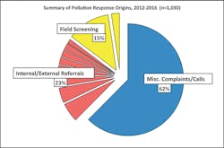
It is important for stormwater managers to know where IDDE reports originate to anticipate needs and prioritize resources. The five-year study is able to comprehensively provide this understanding. We learned that the majority of reports generated from 2012 to 2016 came from miscellaneous internal and external complaints and calls (62%). By combining different IDDE response origin types, we can also formulate a percentage that directly corresponds to permit-required field screening efforts (15%). Finally, many of the other report types (i.e., referrals from the Department of Ecology, Health Department, or internal source control programs) can now be listed, counted, and individually tracked (Figure 6) in the future to improve stormwater program effectiveness.
Of the 360 Road Ops IDDE responses during the five-year period, 80% involved petroleum pollutants. A more in-depth analysis was performed that segregated records into the following two distinct work tasks:
- Road Ops response to petroleum spills in the right of way
- Road Ops response to petroleum spills and leaks from its own equipment
This effort revealed that Road Ops petroleum responses recorded from 2012–2016 were proportioned as 61% right-of-way spill responses (2.8 per month), and 39% divisional equipment spill or leak responses (1.8 per month). Due to comprehensive written records maintained by Road Ops, it was also possible to more closely evaluate and eventually produce trends concerning these two IDDE functions.
Over time, responses to spills in the right of way were noted to be increasing. This increase may be due to several factors: better recognition of incidents by Road Ops field staff, an increase in spill reporting (both internal and external), and additional permit requirements for MS4 inspections and assessments that eventually lead to discovery of petroleum-related incidents. Above all, the observed increase may largely be a function of greater numbers of spills and leaks that are generated by a greater number of people and vehicles travelling the county rights of way.
On a positive note, the data denote that the frequency of responses to spills and leaks from Road Ops equipment is decreasing over time. This finding may reflect that enhanced preventative maintenance training provided to county employees is effective in reducing these incident types.
The five-year study of IDDE data also concentrated on the relationship between IDDE incidents and 26 separate sub-watersheds in Pierce County. These sub-watersheds represent a wide-ranging scope of land uses found within the county, from nearly pristine undeveloped regions of the Cascade foothills to fully built-out developed environments—conditions akin to a giant petri dish that are ideal for this type of study.
Because the sub-watersheds vary in size, data were first normalized to obtain IDDE densities (incidents per square mile). The data clearly show that higher densities of IDDE incidents occur where people live and work within more populated parts of the county; lower IDDE densities occur in more remote locations where human influence is less. These data may be tracked over time as the county is further developed.
From here, attention was then placed upon more robust data sets associated with the four sub-watersheds that exhibited the greatest number of verified IDDE incidents: Clover Creek/Steilacoom (269 incidents), Clear/Clarks Creek (122 incidents), Gig Harbor (71 incidents), and Mid Puyallup (56 incidents). Combined, these four sub-watersheds made up 75% of all IDDE incidents recorded across the county during the study period.
By a large margin, the study indicates that petroleum was the IDDE pollutant most often verified in these four sub-watersheds: Clover Creek/Steilacoom (60%), Clear/Clarks Creek (43%), Gig Harbor (61%), and Mid Puyallup (46%).
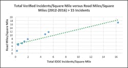
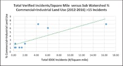
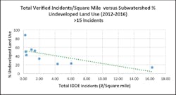
The study also closely examined the relationship between percent impervious areas, road miles, and land use for sub-watersheds in Pierce County having 15 or more IDDE incidents during the study period (Figures 7, 8, and 9). When graphed, the data variables exhibit a very strong relationship: 1) the number of IDDE incidents increases as the percentage of impervious area increases, 2) the number of IDDE incidents increases as the road mile density increases, 3) the number of IDDE incidents increases as the percentage of commercial-industrial land use increases, and 4) the number of IDDE incidents decreases as the percentage of undeveloped land use decreases. (An even stronger correlation exists with these factors when the population of petroleum-only incidents is plotted.)
Conclusions
This study provides further support and justification for converting the current general permit approach for stormwater to a watershed-based approach. Presently, state of Washington municipal stormwater permits seek to achieve focus by incorporating regional efforts that encompass public education programs, a pay-in mechanism for water-quality monitoring, and IDDE source identification and diagnostic monitoring. However, these regional approaches have fallen short in generating meaningful jurisdiction-specific information needed by stormwater managers to improve watershed health.
“Here at Pierce County, in addition to the performance baseline and metrics established for IDDE program evaluation and administration, we have similar metrics for stormwater facilities inspection sites with rates of compliance by watershed. We also have well-established ambient watershed health trends that are showing improvements in water quality across the county, which we publish in our annual Watershed Health Report Card,” says Dan Wrye, surface water quality manager. “All of these metrics—IDDE, inspection results, compliance trends, and watershed health trends—have been developed using local data by Pierce County for management of its stormwater and water-quality efforts. A watershed or jurisdiction-specific stormwater permit would complement our programs by looking locally and devising solutions to meet watershed-specific needs.”
The value of the five-year Pierce County IDDE Study is broad and far-reaching. Externally, it lays the groundwork and provides a template for other MS4 programs to build upon. Internally for Pierce County, the study provides many benefits, including:
- Identifies IDDE pollutants of concern, trends, and problematic drainage basins
- Confirms the relationship between stormwater pollutants and land use, percent imperviousness, and road mile densities
- Effectively organizes IDDE database for additional/future study, and increases understanding of program functions and efficiencies
- Improves county permit-required IDDE recordkeeping.
- Tracks IDDE efforts in TMDL areas
- Assists in prioritizing capital improvement program investments
- Empowers IDDE staff, instilling an understanding and pride in their work
- Provides the public information concerning what the SWM utility does (tax dollars at work)
- Complements public education campaigns (Don’t Drip & Drive)
- Promotes stewardship within water shed councils and the community
- Provides additional supporting data for water-quality grant applications
- Establishes baseline performance metrics for IDDE program metrics
- Identifies IDDE “hotspots” by watershed
- Helps to form a calendar of expected IDDE reports
