Not too long ago, there were only two colleges in the United States where one could learn about stormwater management, notes Brant Keller, public works director for Griffin, GA.
“A lot of places are starting to pick up on it, that the issue of being a stormwater manager isn’t just an engineering function,” he says, acknowledging the increased emphasis on multidisciplinary stormwater education at institutions of higher learning.
That factor underscores projects that have garnered honors from EPA through its Campus RainWorks Challenge. Addressing stormwater as one of the nation’s most widespread challenges to water quality—affecting both human and environmental health—the national college competition is designed to engage the next generation to create solutions for stormwater pollution for their campus and the larger community, applying green infrastructure principles and design through interdisciplinary collaboration.
The master plan category examines how green infrastructure could be integrated into a broad area of a school’s campus. The demonstration project category examines how green infrastructure could be integrated into a particular site on the team’s campus. Below, we highlight the first- and second-place winners in both categories.
The two first-place student teams in the EPA competition will be awarded $2,000 to be split evenly among the members. The faculty advisors will receive $3,000 for their institution.
The two second-place student teams will be awarded $1,000 to be split evenly among the members. The faculty advisors will receive $2,000 for their institution.
Kansas State University
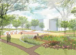
Kansas State University (KSU) took first place in the demonstration project category with its “Stronger Quinlan” project, which proposes repairing a historic campus nature area with green infrastructure elements to reduce stormwater pollution and flash flooding of Campus Creek.
Details from City College of New York’s project, which took first place in the master plan category
The students estimate their design could reduce stormwater runoff by 46% in the vicinity of the Quinlan Natural Area by capturing approximately 597,000 gallons of water annually for irrigation, according to Trisha Moore, assistant professor of biological and agricultural engineering and a faculty advisor to the team.
A six-member student team representing biological and agricultural engineering, agronomy, entomology, and landscape architecture disciplines worked under the direction of four faculty advisors in biological and agricultural engineering, landscape architecture and regional community planning, and campus planning and project management.
“This was the first time our landscape architecture [LAR] students engaged in a project with an entomology student, so it was a unique and a terrific learning experience,” notes Lee R. Skabelund, PLA, ASLA, associate professor in KSU’s Department of Landscape Architecture and Regional and Community Planning and College of Architecture, Planning and Design. “Coupled with the soils/agronomy student on the team, having someone from entomology really deepened the design and engineering thinking by our LAR and bio-ag engineering students,” notes Skabelund, who served as a project advisor.
Kelsey McDonough, a doctoral student in biological and agricultural engineering, notes that the “interdisciplinary nature of our team provided a strong base to develop an innovative design that transcended the capability of our individual disciplines.”
The Quinlan Natural Area is a woody riparian zone located at the downstream end of the Campus Creek stream corridor, buried and daylighted at several locations. It is dedicated to Leon Reed Quinlan, a Harvard graduate who came to KSU as its first campus landscape architect, planting hundreds of tree and shrub species throughout campus marked with nameplates bearing the common and botanical names and using wooden stump seating features in a shaded woodland area.
“The natural area, which is along the Campus Creek corridor, already offers natural seating areas and native tree species, but it has fallen into disrepair,” says Mark Taussig, associate director of Campus Planning and Facilities Management with the university’s Division of Facilities and a faculty advisor to the team. “Development upstream to the north of the Strong Complex has created a large impermeable watershed that generates large volumes of stormwater runoff during heavy rains, exceeding the capacity of Campus Creek. The result is frequent flash flooding in the natural area as well as to the residential area east of it.”
Additional impacts include poor stream water quality, accelerated channel erosion, and poor habitat conditions such as unmaintained banks overgrown by invasive species.
The project is designed to disconnect the Strong Complex watershed from Campus Creek by capturing and infiltrating stormwater runoff at the source as a first step in alleviating flooding.
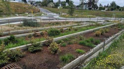
With roofs comprising a significant portion of the impervious area, the proposed design disconnects downspouts from the dormitory roofs that currently pipe water directly to Campus Creek and uses three cisterns storing 30,000 gallons of water to rapidly collect stormwater, slowly releasing the stored water over a 48-hour span to a bioretention cell/detention basin system to promote onsite infiltration for groundwater recharge and improved water quality.
Bioretention cells were chosen for their ability to restore predevelopment hydrology by mimicking the natural hydrologic regime, reducing average peak flows from 45 to 99%.
The KSU bioretention cell system has been designed to effectively capture and store a 1.1-inch storm event, while the detention basin is sized to detain the 25-year, 24-hour recurring storm event (5.98 inches).
The detention basin, chosen for its effectiveness at controlling and detaining runoff volume—especially during larger storm events—was sized to handle more frequent and intense storms anticipated with climate change.
Stormwater collected in one cistern is allocated for campus irrigation, reducing water demand from the city of Manhattan. The other two are slated to slowly release their total volumetric capacity at a rate of 1.7 gallons per minute through a runnel network for maximum infiltration.
The design also creates an interactive water plaza emptying into a central bioretention cell after flowing through an eco-revelatory plaza bisecting a main pedestrian thoroughfare, serving as a demonstration site for the value of green infrastructure for the 24,000 people who interact with the site annually.
The woody riparian area along Campus Creek in the Quinlan Natural Area was restored in the design to create an additional creek buffer, providing shaded pathways and stump seating areas for visitors.
The design recommends a 5-inch pervious concrete layer supported by 8 inches of gravel subbase with a capacity to store stormwater from the 10-year, 24-hour storm while providing adequate structural support for pedestrian traffic and emergency vehicles. It was selected to enhance the natural hydrologic components of infiltration and storage, with research showing an average runoff volume reduction between 50 and 93% in clay soils with control storms of less than 2 centimeters, and retaining the first flush runoff of larger storm events.
Elements such as native vegetation and an urban tree canopy are applied throughout the site, providing habitat and improving aesthetics while being drought and flood resilient, mitigating the urban heat island effect, and decreasing water demand.
The Kansas climate is historically prone to extreme weather swings with long periods of drought followed by periods of intense rainfall and temperature fluctuations from very hot and dry in summer to cold, snowy, and windy in the winter. Northeastern Kansas is expected to experience more climate change–related volatile weather patterns, such as shorter and more intense precipitation events, while droughts will be hotter and of greater duration. The temperature and precipitation shifts are expected to place extreme stress on existing water supplies. The proposed site is designed to manage natural water resources by increasing water storage, decreasing water demand, and promoting groundwater infiltration and recharge.
The project also is expected to provide biological control of mosquitoes, which have been a persistent nuisance on the KSU campus.
Grasses native to the tallgrass prairie of Kansas, such as little bluestem and switchgrass, have been found to promote infiltration and prevent erosion due to their fibrous root structure. Native shrubs and forbs—which provide habitat for a wide range of pollinators, monarchs, and wildlife and reduce stormwater runoff by promoting infiltration, evapotranspiration, and groundwater recharge—will be planted in the bioretention cell and detention basin.
Plantings in the wooded riparian area include wingstem and Emory’s sedge, resilient to poor water quality and providing pollinator habitat; buttonbush, providing pollinator habitat and erosion control; and fox sedge, providing bioremediation, erosion control, and habitat.
Plantings in the bioretention cell include Indian grass for habitat, erosion prevention, and infiltration promotion; swamp milkweed and tall thistle to provide nectar and habitat for pollinators; and switchgrass for bioremediation, erosion prevention, and infiltration promotion.
Detention basin plantings include big bluestream for promoting infiltration and preventing erosion; little bluestem for bioemediation, erosion prevention, and infiltration promotion; and sweet coneflower for providing nectar and habitat for native bees.
The hydrologic modeling software PCSWMM was used to simulate the hydrologic function of the project site and compare current environmental conditions to the proposed site design.
A 3-meter digital elevation model was delineated to determine the watershed topography, and hydrologic soil group C was used for the site area. Precipitation information was obtained from the city of Manhattan and the National Oceanic and Atmospheric Administration Precipitation Frequency Data Server.
The SCS Curve Number method was used to estimate the runoff volume in each scenario. The model applied dynamic wave routing for event-based simulation of site conditions.
The quantitative analysis found that the proposed design effectively reduces stormwater runoff.
The project is expected to be executed in three phases over a six-year schedule with an approximate cost of $526,000, with funding partially procured in cooperation with KSU’s 2025 master plan, which outlines strategies to provide opportunity for sustainable growth.
The project has the support of Taussig, who says it could fit in well with the university’s long-range master plan. “The proposed system will have long-term benefits of improving stormwater quality and reducing peak flow and volumes, doing so in a manner that fits with our unique eco-regional context,” he says. “The flow of campus stormwater is one way the campus interfaces with the community, so this green project would be viewed favorably by our downstream neighbors.”
Additional funding is sought through contributions from the city of Manhattan. Grants such as the EPA’s Source Reduction Assistance Grant Program and the Federal Emergency Management Agency’s Pre-Disaster Mitigation Program are available as potential funding sources.
“The design will be a wonderful green infrastructure demonstration site, providing learning and research opportunities,” notes Jessica Canfield, associate professor of landscape architecture and regional and community planning.
University of Maryland
Taking second place in the demonstration product category: the University of Maryland’s (UMD) “(Un)loading Nutrients” project, which proposes transforming a campus loading dock into a campus amenity that also manages stormwater.
The 22-member multidisciplinary team consisted of project leads, consultants, and advisors representing landscape architecture, mechanical engineering, architecture, environmental science and technology, plant science and landscape architecture, facilities management, and civil and environmental engineering, among others.
The team selected a 0.97-acre lot on the southern half of campus that was 96% impervious and lacking stormwater best management practices (BMPs).
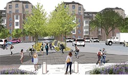
Plans call for 6,660 square feet of new plantings for bioretention and for reducing impervious surface by 18%. The students’ redesign of the loading dock and adjacent parking lot aims to create a safer pedestrian walkway between a dining hall and classroom building while minimizing parking loss and disruptions to loading dock activities.
The project captures and provides treatment for a two-year, 24-hour storm event. It increases tree canopy coverage and vegetative cover with a climate-resistant plant palette and provides habitat and food resources for wildlife in the context of a changing climate.
It also provides opportunities for students, faculty, and staff to learn about stormwater BMPs.
The UMD Facilities Master Plan identifies water conservation and stormwater management as part of its sustainability focus. Among the goals of the University Sustainability Council’s Water Use and Watershed Report is adopting an initiative to reduce purchased potable water 20% by 2020.
The group prioritized using BMPs to achieve the goal of treating runoff from the first inch of rainfall from 50% of all impervious surface area
by 2020.
The work group recommends stormwater management practices be coupled with education and research missions. With a new municipal separate storm sewer system (MS4) permit expected to be issued soon, UMD Facilities Management is expecting a 20% increase in the volume of stormwater requiring treatment. Although retrofits implemented after the last MS4 permit issued in 2005 will count toward the goal, meeting it will require significant additional stormwater treatment throughout campus, with opportunities receding as the campus continues to develop available open land. The site could serve as a catalyst project by fixing a poorly functioning space while incorporating innovative stormwater management techniques.
The design proposal serves as a potential model for BMP retrofits that serve the social and academic needs of students while addressing ecological factors contributing to the poor health of the Chesapeake Bay watershed.
In proposing a practical and cost-efficient stormwater retrofit using a map of the underground utilities from the facilities management department, the team created a design that prevented potential conflicts. They also identified some problem areas.
For example, the team located two existing storm drains in the southwest corner of the parking lot, finding one clogged with construction debris. The ground around the working drain is not properly graded, with ponding occurring around it during rain events.
The high point of the South Campus Dining Hall loading dock/parking lot is located at the northeast corner. The site is 96% impervious and is graded so that runoff generally flows from northeast to southwest; the vast majority of the rainfall does not infiltrate. Parked and idling vehicles on the site’s asphalt pavement potentially lead to polycyclic aromatic hydrocarbons (PAH) accumulation.
The design calls for storing and treating runoff from a two-year storm by using bioretention, chosen for its ability to significantly reduce PAHs and remove total suspended solids from urban stormwater runoff, with reduction ranging from 54 to 99%.
Plans call for the use of PaveDrain, a permeable articulating concrete block paving surface. Its aggregate bedding stone is designed with recycled materials to create a natural, vertical infiltration path that recharges local groundwater and filters first-flush pollutants.
The system includes an arch design in the middle of an articulating concrete block to create an internal storage chamber used as a reservoir for stormwater runoff while simultaneously providing strength for heavy vehicular loads.
The pedestrian corridor is improved in the project through the installation of a buffered walkway, including 4,500 square feet of pervious pavers to allow infiltration
of runoff from the loading dock area.
The heat island effect is mitigated with increased tree canopy coverage through the installation of 3,000 square feet of vegetative cover and 10 native trees selected for their ability to withstand wet and dry conditions and extreme heat. The plantings also provide food resources for wildlife and aesthetic value for passersby and include red maples, blackgums, native southern bayberry, summersweet, fox sedge, purple coneflower, and goldenrod.
The site also features learning opportunities through controlled experiments allowing for comparison of bioretention media.
The total project cost is $211,122, with the potential for funding to come from the UMD Sustainability Fund, which offers grant money for projects that improve environmental sustainability and enhance the student experience.
“Stormwater is a hot topic these days,” notes Michael Carmichael, a stormwater management and maintenance inspector with UMD’s Facilities Management Department, who helped advise the students. “It is becoming an important topic when talking about the environment. We receive numerous requests to learn more about our stormwater infrastructure on campus.” Many of those requests come from students pursuing minors in environmental science, engineering, architecture, landscape architecture, and sustainability, he adds.
“When students from multiple disciplines come together to collaborate on projects such as this, it makes for the greatest outcome, because the project is approached from a variety of perspectives. A variety of considerations are taken into account,” says Carmichael, adding that the approach “more closely resembles the work done in the professional arena. Most projects in the world are created and executed by a host of professions that come together to lend their expertise.”
The students already possessed a working knowledge of stormwater when initiating the project, notes Carmichael.
“We encouraged them to consider water movement through their project space, with special consideration of topography,” he says. “That meant looking at what runoff is doing well outside the project area. We asked them to consider how this affects the placement of stormwater mitigation, traffic patterns, design, and other factors.”
City College of New York
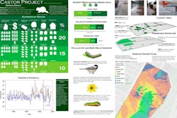
City of College of New York (CCNY) took first place in the master plan category with its “Castor Project,” named after the school’s mascot, the beaver (Castor canadensis).
With the beaver serving as an example of a natural water manager, the team designed a master plan for campus-wide stormwater management calling for increasing tree canopy 15% by adding 89 trees and reducing impervious area 38% by adding 23,000 square feet of permeable surface. A water storage tank could capture up to 3,000 cubic feet of stormwater for graywater uses.
The project’s goals are to reduce stormwater runoff between 10 to 20% during a five-year, 24-hour rain event and to increase permeable area from 8 to 9 or 10%.
The project was executed by a five-member student team representing environmental engineering, landscape architecture, and advertising and public relations programs and led by two civil engineering professors.
The impact of population growth and climate change on the demand for clean water are the driving factors in the project. For much of the urban northeast United States, historical observations and general circulation models show a trend toward warmer temperatures and more intense precipitation, with New York City likely to experience more extreme rain and snow storms, creating more stormwater for city’s infrastructure to handle.
To that end, the CCNY project focuses mainly on the north area of the campus because of its significantly less permeable soils and older buildings. The campus consists of buildings on either side of a 5-block stretch of its main thoroughfare, primarily serving pedestrians. South of the northern border of the campus is a high elevation point, causing water to flow either north or south. The campus houses several neo-Gothic buildings built in the early 20th century. Only 8% of the area is green space. The project focuses on increasing surface permeability to promote infiltration, increasing evapotranspiration via new plants, and capturing water using storage tanks.
A climate study was conducted to ensure the Castor Project’s resilience to changing climate. Historical observations from Central Park—which at 2 miles away has the nearest weather station to CCNY—show that the five-year return period storm is 2.2 inches of rain in a day.
The campus project transcends the traditional framework of designing for historically observed rain events and incorporates climate-informed simulations of future weather into its analysis. The team developed a climate-informed stochastic weather generator to identify future stormwater management needs, starting with using a two-state hidden Markov model to identify trends in annual-scale precipitation. They then fit state-specific generalized linear models for precipitation occurrence and intensity using observed climate/regional atmospheric predictors, so the weather-generators were climate-linked, enabling the generation of future extreme events.
A weather generator was run 1,000 times to simulate new five-year return period values and to identify the risk of failure for a variety of future scenarios. The simulations led to an increase of 6% in design storm intensity.
To calculate the total volume of runoff on campus during a rain event, the team used a traditional NRCS Curve Number method, approximating the initial abstraction of precipitation due to infiltration, pooling, and evapotranspiration by using a ratio-method dependent on the land cover characteristics of a parcel of land. The remainder of the precipitation is deemed “effective,” becoming stormwater runoff.
The campus project is designed using a modified version of the NRCS method based on a 2006 study that found urban watersheds had significantly lower abstraction ratios. The team surveyed and classified the campus, finding a composite curve number of 96. The conclusion was to control a percentage of the 2.03 inches of effective precipitation.
The project takes a systematic approach to implementing green infrastructure on CCNY’s campus, with elements and locations achieved via an integer programming optimization model.
The model was designed to minimize the cost of the entire plan while meeting constraints on a minimum volumetric water reduction, a minimum permeable area increase, and other design goals.
To preserve ecological and aesthetic value, the team calculated the design cost of a single bioswale and then considered sections of bioswales along the main campus thoroughfare.
A basic element of the model is the desired amount of volumetric stormwater reduction on campus:
10, 15, or 20%. A fractional coefficient of the total daily volume of flow during a five-year rain event was set as a minimum capture constraint and then cost-minimized for several volumetric runoffs. The model is designed to increase permeable area by at least 15%.
The Castor Project presents three choices for implementation based on the desired reduction of total flow: 10% (mild), 15% (moderate), and 20% (severe). Each increase in severity includes the design elements from the previous scenario. The recommended course of action is to first implement the mild scenario, then re-evaluate precipitation patterns after five years and adjust implementation accordingly.
The design team surveyed students on campus for their knowledge of campus water supply and stormwater management, their willingness to pay for upgrades, and their support for student-led initiatives. Most respondents indicated support for sustainable water usage on campus—finding student-run, on-campus environmental initiatives effective—and a willingness to pay to help fund sustainable water usage on campus.
While the majority of students were familiar with green roofs, low-flow toilets, and sewage overflows, most were unfamiliar with graywater systems, which could be implemented to reduce potable water usage. That result suggested the need to incorporate information about the New York City water supply and its management, water conservation, and the maintenance of clean waterways into the project’s educational efforts.
Other project goals include educating high school and university students about sustainability, green infrastructure and design, and other environmental issues and challenges.
Financing for the project might include government support from New York City, given its similar goals to the city’s Green Infrastructure Program and stormwater management plan. The project will undergo a formal review by various city agencies, including the City University of New York Board of Trustees and the NYCDEP.
University of Cincinnati
The University of Cincinnati (UC) took second place in the master plan category for its “ReMEDiation” project, calling for the installation of green infrastructure BMPs to mitigate campus stormwater runoff and reduce flooding and CSOs into the Ohio River by an estimated 25% while increasing community benefits of urban gardens and nature trails.
A five-member team of students enrolled in a green infrastructure course and representing horticulture, natural resources and environmental sciences, and community planning designed the project, led by a School of Planning faculty advisor.
The goal of the project is to remediate the current impervious nature of UC’s East Campus to address stormwater and climate change concerns while capitalizing upon the campus’ strengths in location between two communities and its provision of health services.
The project additionally promotes education and opportunities for health and healing, and it supports long-term sustainability of the East Campus, surrounded by a large urban park.
Project advisor Leah Hollstein points out that as do many older cities in the US, Cincinnati has a combined sewer system and has been required to deal with combined sewer overflow occurrences. This concern, and the potential of green infrastructure to contribute to improved physical and mental health, inspired the design team to focus on UC’s East Campus— the medical campus—for its RainWorks submission.
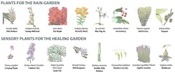
“Students really thought about the healing properties of plants and well-designed spaces, particularly for the visitors and patients who use this campus regularly,” says Hollstein. “Their design—particularly the plant specifications—targets the needs of visitors to this campus.”
The team noted an abundance of impervious pavement and identified spaces that could have more functionality built in through green infrastructure, adding to the East Campus’ overall character and functionality.
An in-depth analysis used GIS, the EPA’s stormwater calculator, historic context analysis, and a site visit.
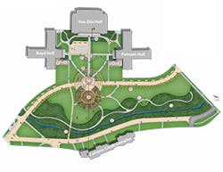
The plan focuses on a multi-functional green space, East Commons, and a Healing Garden as two green infrastructure hubs at either end of the campus. A green connection featuring bioswales and a green facade link the two areas.
ReMEDiation is focused around five guiding themes:
- Environmental health: Reducing stormwater runoff by 25% and improving stormwater infiltration by decreasing impervious surfaces and installing rain gardens and bioswales, as well as rehabilitating vegetated space and biodiversity by planting native, habitat-strengthening vegetation
- Health and healing: Providing opportunities for outdoor fitness for students, employees, and patients through a system of urban nature trails, and increasing access to fresh fruits and vegetables for students and community organizations by planting edible plants as well as create spaces for reflection and healing by constructing healing gardens
- Education: Supporting integrated academic programming, promoting green infrastructure through instructive signage and outreach to surrounding Cincinnati public schools, and exploring education outreach opportunities with Children’s Hospital
- Community connections: Restoring the site’s connection with the surrounding environment, and including the UC student body and community organizations in green infrastructure installation, maintenance, and programming
- Long-term sustainability: Addressing anticipated climate change threats, such as increased rainfall and temperatures
The average slope on East Campus is 5%. Its highest elevations are on the eastern edge and slope toward the west-northwest corner. The average tree canopy is 6%. About 70% of the area is impermeable surface.
The ReMEDiation plan is focused around an S-shaped green connector linking the East Commons with the healing garden through a system of pocket rain gardens, green facades, and bioswales. Permeable pavement creates the S-shaped connection from the community of Avondale to the urban forest, branching off into parking lots. It features rain gardens with native species for visual interest and allows stormwater infiltration into the soil. Green facades on the sides of parking structures help absorb heat.
Bioswales are substituted for paved medians, capturing runoff and naturally filtering parking lot pollutants.
Expected outcomes include a 1.22-acre reduction in impervious area. The project is expected to reduce runoff from current levels by approximately 9%, with infiltration increasing by 11%. The site receives approximately 43 inches of precipitation annually, so the runoff depth is reduced about 10%.
The plan is in its first phase. Achieving a 20% reduction in stormwater runoff will require more interventions, such as rainwater harvesting. The project will be rolled out in four phases over five years.
Hollstein points out that the team that came up with the campus approach to stormwater and green infrastructure was composed of planning and horticulture students who interfaced with the UC office of Planning + Design + Construction.
“In addition, their semester was spent learning about stormwater and other types of green infrastructure from the perspectives of ecology, marketing, finance, public administration, engineering, and the social sciences, in addition to urban planning and design,” she says. “These disparate elements are clearly seen in their multifaceted approach to the design problem.”
She says one thing the students found most surprising was “the sheer scale of runoff that occurs in a typical US city. Our cities are rife with impermeable pavements, and while we do have green areas in cities, their soils are largely impacted and thus practically impervious. The amount of stormwater that green infrastructure applications would need to control, slow, and clean in order to make significant progress on our CSO problems is overwhelmingly large for any but the largest green infrastructure applications.”
Hollstein, who teaches in an urban planning program, says, “Stormwater—along with many environmental concerns—has not traditionally been a topic of interest in this field. With climate change, conflicts over resources, and the movement toward associating dollar costs with their drivers—such as pollution—stormwater and other green infrastructure tools have become more mainstream. The idea is that someday, hopefully soon, I will not be able to teach this class as green infrastructure will be the norm and not an alternative option.”
Beyond the Classroom
Keller lauds the interdisciplinary approach “because a lot of engineers are more vertical-thinking. Architects—who I call watercolor specialists—have a tendency to balance them out.”
But he notes that many students skilled in stormwater management will seek higher-paying employment in the private sector upon graduation. As a result, Keller says, he’s developing stormwater management talent in-house starting with students as young as 16 years old when they can legally begin employment. One young woman worked for seven summers learning do stream reaches and outfall inspections and to work with GPS; she was offered a job as an environmental technician.
To mitigate both budgetary concerns and personnel shortages, stormwater departments can leverage the skill sets being taught at local universities, points out Keller. Griffin, for example, was able to tap into work being done by engineering students at Georgia Tech. A senior project entailed an eight-member team that designed the replacement of new pumps and evaluated existing pumps to determine whether they needed to be variable or adjustable speed. “That project worked out well, and we implemented their design,” notes Keller.
As more designs encompass green infrastructure and low impact development, their costs become a factor of consideration given the second round of MS4 stormwater permitting in states, says Keller, adding that many 319 grants are funding green infrastructure such as micropools and streambank restoration.
Keller doesn’t see managing budgets for stormwater designs as being a challenge for emerging stormwater professionals. “They are computer savvy,” he says. “You can find a lot of information online, so they can find out the value engineering.”
One issue Keller does note, however, is that although newly graduated engineers have been immersed in an intensive study of technical and engineering skills, “they forget that they have to communicate with other people.”
Taking on a management position means communicating in layperson’s language to a director or board, “and these are some of the skills I’ve seen that are still lacking out there,” says Keller.
THE NEXT CHALLENGE
EPA recently announced the rules for the 6th annual Campus RainWorks Challenge. The design competition is open to US colleges and universities. EPA seeks to engage undergraduate and graduate students in designing innovative green infrastructure for stormwater management to showcase the environmental, economic, and social benefits of green infrastructure practices.
Registration is open September 1–30, 2017.
The deadline for entries is December 15, 2017. Winners will be announced in the spring of 2018.
For more information, visit https://www.epa.gov/campusrainworks.
RECOMMENDATIONS FROM THE FIELD
We sent a survey to professionals throughout the stormwater industry and received hundreds of responses. Among the questions we asked:
What education or professional certifi cation do you have that has helped your career? What would be most valuable for someone looking to get hired or to advance within the field?
The responses were varied, but the most popular recommendation by far was a civil engineering degree. Other areas of study that were frequently
mentioned include environmental sciences, hydraulics and hydrology, hydrogeology, landscape architecture, and water quality and water resources.
Respondents also recommended many different professional certifi cations and qualifi cations. Among the most frequently mentioned: the Certified Erosion and Sediment Control Lead (CESCL) certifi cation in Washington state; Certified Environmental and Safety Compliance Offi cer (CESCO) certification; Certified Floodplain Manager (CFM) certifi cation; Environmental and Water Resources Engineering (EWRE) programs; Leadership in Energy and Environmental Design (LEED) accreditation; and Qualifi ed SWPPP Practitioner (QSP) and Qualifi ed SWPPP Developer (QSD) training in California.
We also asked respondents to list specifi c universities and programs they are aware of that have a specifi c focus on stormwater. We received more than two dozen. These are available on our website here.
And many of those who responded also emphasized that there’s no substitute for experience: “Any of the professional certifications are valuable,
but boots-on-the-ground experience is best,” one commented.
