Extreme weather events continue to occur more frequently throughout the country, impacting many of our watersheds. Along the East Coast, for example, we experienced record rainfall amounts in the Mid-Atlantic and Southeast during the 2018 hurricane season and into 2019. Warm, moist coastal air fueled south-to-north trending weather patterns and continuous rainfall events, which occurred roughly every two weeks during this timeframe.
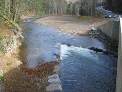
These patterns are increasing in both frequency and strength. Recently, a restored reach of a glacial outwash, wild trout stream channel located within a confined floodplain in northcentral Pennsylvania was re-impacted. Prior to this event, natural channel design (NCD) restoration, including stream-flood flow redirective and resilience stabilization measures, was implemented on this stream in 2017. This followed an October 2016 extreme event that dropped 8.5-inches of rainfall over a four-hour period within the 36-square-mile watershed. The 2016 event created flow depths more than 16 feet high. The high angle of attack channel alignment scour removed 320 linear feet by 60 to 70 foot-high upstream approach roadway embankment and floated a downstream two-span bridge deck approximately 500 feet into the mainstream. As a result, our team at Dewberry was asked to design the bridge replacement, embankment, and NCD stream channel restoration and implement resilience measures.
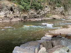
The recent second event was much less impactful due to the 2017 restoration, which included numerous NCD resilience measures to the upstream and downstream reaches. However, the midstream reach area, which had not received significant restoration treatment, was now impacted. This new event downcut through prior bedload sediments, undermined the right vane arm, and sheared the 3- to 5-ton top rock from the downstream bridge rock cross-vane, creating a more sinuous flow path in the process. Remaining bedload accumulations from the 2016 event were transported downstream into the mainstem, where additional channel instabilities have been occurring since the 2016 extreme event. During this second event or channel “adjustment process,” additional channel formation and scour had created a more sinuous low-flow channel with deeper pools and a significant increase and overall improvement in the habitat on this native wild brook trout stream, which was one of the reasons for the prior NCD restoration.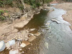
We are now restoring numerous other emergency slope repair, embankment, and structure replacement projects using NCD and resilience approaches, where appropriate and as funding becomes available, in areas that had recently been impacted over the last few years within northcentral Pennsylvania. Similarly, we are advancing on another project currently in design for restoration located in northcentral Maryland. This project involves a small unnamed tributary situated in a confined floodplain. As is becoming increasingly common, the small bedrock-controlled tributary has been impacted by extreme rainfall events three times in the last five years. Each time, riprap-lined embankments located along the outside of meander bends were sheared by the 4- to 5-inch short-duration rainfall events. These events resulted in lateral channel migration and moved rock material ranging from football-sized up to 18-inch D50, shearing and dislodging the rocks from the embankment and carrying them downstream. Similar events occurred about 30 miles east of the project area in Ellicott City, which had been impacted twice during the same timeframe, along with streams located in nearby southcentral and southeast Pennsylvania counties.
An Increasing Need for Resilience Measures
When we review and reflect on these extreme precipitation events and their storm tracks, it becomes apparent that there is a reoccurring process at work. Storms tend to travel along the jet stream, a path that is altered by changes in temperature and low-high pressure systems. Large stagnant systems become fixed and develop “atmospheric rivers,” where repeat storms travel, continually resulting in extreme weather event areas of impact.
Throughout 2018 and into mid-2019, numerous weather systems were observed moving up the East Coast from south to north within the Chesapeake Bay Watershed. Warmer, moist air masses associated with the coastal areas, the Chesapeake Bay waters, and the Susquehanna River Valley fed the development and continuation of these extreme rainfall events that had been topographically contained by the Appalachian Mountain chain to the west and northwest. This line of storms traveled along the Susquehanna River Valley to Williamsport, PA, and into the upper portions of the Chesapeake Bay watershed, where these systems stall or rise orographically through the northern tier of the Appalachian Mountain ridgeline and drop extreme, high-intensity, short-duration rainfall amounts. In the summer of 2019, a one-inch rainfall occurred in a 15-minute timeframe near Williamsport. Soils supporting slopes become saturated and high flows in streams scour toe support from glacial deposits and soil embankments, resulting in roadway embankment supporting slope failures and landslides.
Within the Mid-Atlantic region, studies have determined that rainfall-runoff amounts have increased and are occurring more frequently. Thirty years ago, a 100-year event may have been equivalent to a 6.5-inch rainfall amount. Due to the increased number and frequency of extreme event rainfalls, this same rainfall amount is now typically a 50- to 75-year event. Many states are in the process of revising their bridge and culvert design criteria to reflect these more frequent, increased rainfall-runoff events and to address future changes. For example, Dewberry is supporting both the Virginia and New Jersey departments of transportation in this infrastructure design storm and resilience reevaluation process.
Preparing for Extreme Events: NCD Restoration and StabilizationVulnerable infrastructure impacted by extreme events can be restored and resilience improved by using NCD restoration and stabilization techniques. We can design for these more frequent and extreme events, while mitigating increased storm and flood flows and volumes and meeting water quality requirements through flood-prone areas and floodplain reconnection.
Where extreme events frequently result in major infrastructure impacts, NCD restoration approaches can be planned, along with hazard mitigation approaches, and be more effectively implemented. Approaches to identify appropriate site-specific hazard mitigation and watershed-holistic, integrated restoration approaches include design considerations, options, and opportunities such as:
- developing extreme event resiliency through incorporation of redundant measures;
- identifying flood/shear-scour susceptible areas with vulnerability assessments and analyses;
- performing proactive vs. reactive channel instability restoration and hazard mitigation including FEMA BRIC Program opportunities;
- providing hydrologic mitigation (reduce/delay/desynchronize peak flows) with floodplain reconnection/wetlands/forest buffer/reforestation;
- evaluating local and regional sediment management and transport sources;
- developing habitat restoration and enhancement jointly with stabilization; and obtaining MS4-TMDL, pollutant reduction credits through NCD restoration.
As we develop NCD restoration-based solutions to impacted streams and watershed areas, we must understand the storm events, failure mechanisms, and associated existing and pre-existing conditions. Identifying prior upstream alterations and previous maintenance and management measures is critical to determining the appropriate restorative measures that will survive severe weather events. To predict and model proposed stream restoration treatments and develop resilient scour countermeasures, we need to understand and evaluate the contributing watershed hydrogeomorphic vulnerabilities, failure mechanisms, and sediment sources and transport characteristics. We must determine natural geologic versus accelerated scour and erosion rates, identify flood-impacted streams, preemptively mitigate for climate change-related impacts, practice longitudinal and lateral reconnection (floodplain reconnection) for improved sustainability and resilience.
In the process of restoring and stabilizing impacted and impaired stream reaches, we must also provide aquatic habitat and improve water quality through riparian buffer restoration. We must look for opportunities where gray and green, natural, nature-based infrastructure (NNBI) rehabilitation and replacement can be paired effectively with stream restoration and stabilization activities for improved resilience. By effectively integrating resilient gray and green NNBI improvement, the creation, restoration, and reconnection of natural resources (floodplains, wetlands, riparian buffers, and aquatic habitat) can also result in triple-bottom-line benefits, including TMDL credits and continued opportunities for pollution reduction within the Chesapeake Bay and other watersheds.
About the Author
Tom Graupensperger
Tom Graupensperger is a senior environmental scientist, project manager, and NCD restoration designer with Dewberry, a nationwide consulting firm.