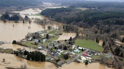
A hot spot for technological creativity and entrepreneurship as well as music and art, the city of Austin, Texas, is home to 800,000 residents, many high-tech and Fortune 500 companies and the main campus of the University of Texas. Bike trails, parks and pedestrian pathways contribute to the city being consistently listed among America's greenest cities.
Austin is located in central Texas on the Colorado River, which crosses the Balcones escarpment, which separates the Texas Hill Country from the Blackland Prairies to the east. Steep slopes in the western part and only a thin covering of topsoil on limestone rock hills produce fast-moving runoff during heavy rainfall, creating dangerous conditions and flash floods.
Because of tremendous runoff potential, Austin is one of the most flash-flood prone regions in North America. Steep slopes and intense rainfall have earned the area its nickname, “Flash Flood Alley.” Better flood prediction information means more time to close roads, reroute traffic, activate high-water signals and deploy emergency personnel before an impending flood. To achieve this goal, both accurate rainfall and model forecasts are provided in a Web-based framework to help protect the public from flood hazards.
Put to the Test
On May 23, 2009, a hydrologic forecast for central Austin’s Shoal Creek provided a one-hour lead time for a downstream location along the 11-mile-long channel. Austin Flood Early Warning System operators took action based on their prior experience with the Vieux Inc. radar hydrology forecasting technology. They provided advanced warning to occupants of pedestrian walkways along the creek. The flood response was accurately forecast, which confirmed results obtained during model setup and calibration. The photos below show the dry creek bed that rose to its banks in less than an hour.
Figure 1 shows the spatial variability of the rainfall during the May 23, 2009, event over Shoal Creek as captured by radar and rain gauges. The storm total increases from near zero in the south, to more than 2.5 in. in the upper reaches of the basin in the north.
Shoal Creek is a fully developed basin covering 13 sq miles and is one of the basins in Austin producing flood hazards. NEXRAD radar is bias–adjusted with rain gauges and is used as input to the distributed hydrologic model V flo for making real-time predictions. V flo has a GSA (U.S. General Services Administration) schedule listing GS-35F-0564V and a U.S. patent. City staff configured the model for the basins using channel cross-sections and geospatial data that includes soils, land use/cover and topography. Besides the elongated shape of Shoal Creek, the other forecast basins have a range of shapes, with areas covering from 5 to 300 sq miles, which makes the network-based modeling approach particularly useful.
Continued Success
As is often the case, rainfall in Flash Flood Alley is highly variable and intense. Remnants of Tropical Storm Hermine produced flooding in Austin on Sept. 7 and 8, 2010. Nearly 13 in. of rain fell in some areas of Austin over the several-day period, producing widespread flooding. City staff used the Vieux Inc. rainfall runoff system to enhance their situational awareness, decision support and rapid analysis of the flood event.
“V flo offers hydrologists, planners and engineers a powerful and efficient modeling platform for storm water planning and operations,” said Jean Vieux, president and CEO of Vieux Inc. “Its adoption and effective use by the city of Austin demonstrates that our products are performing at a high level to help engineers plan for and manage storm water, even in the most challenging conditions.”
Austin and other major cities are turning their geospatial data into hydrologic information that supports regulatory requirements, emergency actions and quick response. Combining accurate maps of rainfall with the gridded model, V flo provides an advanced platform for achieving client success.

