“SWMMing” Through Stormwater Management Challenges
Urban stormwater ruins picnics and ballgames, raises floods, snarls traffic, threatens safety, wreaks destruction, costs cities millions in damage and disruption–and those are among the relatively short-lived effects. Stormwater runoff is also the leading source of water-quality problems nationwide, carrying sediment and other pollutants to lakes, streams, coastal estuaries, and even drinking supplies; one fairly recent persuasive report on this came from the United States National Research Council in 2008.
The resulting management challenges run the gamut from practical design tasks for sizing culverts and channels to flood prediction and permit compliance. There’s a battery of software specialized for each task: modeling flows over hundreds of square miles (above and below ground), triggering flood warnings, tabulating numbers streaming from rain gauges, ensuring MS4 success, performing GPS mapping or GIS tagging of thousands of related sites and assets, providing real time-control of system resources, and backing up and documenting an agency’s water-related zoning decisions. Here’s an assortment of projects around North America that are now using these tools.
Austin: Flash-Flood Alley
“We do have a serious problem with flash flooding in urban areas,” says Susan Janek of the Austin, TX, Watershed Protection Department. “And we will do anything we can do that will give a warning or a forecast to the public and our first responders and give them additional time.”
Starting nearly a decade ago, the city began looking for stormwater modeling software that could be used for flood predictions. “We did an evaluation of our system in 2007, by a consultant who came in and evaluated our particular [team’s function], which is flood warning,” recalls Janek. “He had several suggestions for us to use in terms of predictive mapping and modeling and many different ways to go down that path.” One was the US Army Corps of Engineer’s suite of products–“which is excellent,” she says, “for regulatory floodplain maps.”
But the department ended up using a proprietary model called Vflo, working with the RainVieux radar rainfall application, from Vieux & Associates Inc. of Norman, OK.
Janek’s office began testing Vflo against the Corps’ suite in real time. Vflo’s handling of geospatial rainfall every 15 minutes, “ingested into a hydrologic model,” she says, turned out to be “extremely stable” on the desktop computers. By comparison, the Corps’ suite of models, used in a predictive setting–which the models were not designed for, she concedes–“had issues with desktop computer stability.”
Free trial downloads of Vflo are available from the vendor, she notes. Buying a license cost the department around $4,500 at the time of purchase. Added to this, at $11,000 a month, are the cost of the vendor’s hosting of the models, the 15-minute processed radar rainfall for 4,483 pixels (each pixel being one square kilometer), one-hour forecast rainfall, flood threat scores, and an audible notification service.
That’s a lot of money, she concedes. But 10,000 Austin homes occupy a 100-year flood plain, and another 500 structures will be threatened with flooding in every five-year storm or worse. “So,” she says, “anything we can do to give adequate warning to pull people out of flooding, or preemptively put up barricades prior to road closing, can save lives.”
To begin using the forecasting system, the city first implemented US Geological Survey gauges as forecasting points. Next, starting in 2004, the team worked with USGS to install, develop, and maintain 28 full-range USGS flow rating stations. After gathering and refining the incoming data stream for three years, the city developed a single pilot watershed model using Vflo.
Today, five years on, Austin has completed its detailed rainfall modeling for 70% of its jurisdictional space, covering about 13 watersheds, with two more pending.
In explaining the software’s main role of undergirding the early warning system, Janek says, “What’s key to us is getting the timing and the value of the peak in channel hydraulics.”
The Vflo model ingests gauge-adjusted rainfall data that comes streaming in every 15 minutes, rain or shine. The model then produces a forecast at each USGS gauge.
Guided with this dynamically changing indicator, she says, “We set up certain warnings or thresholds at these gauges so we know when we have either an out-of-bank condition or a road that is overtopped. We’ve got a prediction on how bad it will be, and where.”
The department quickly issues road closings, sets up detours at likely flood spots, and warns occupants of structures at risk.
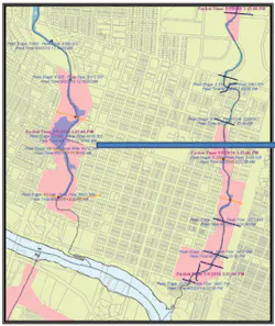
An example of how this process worked with the most recent rainfall at the time of this writing: On this occasion only a few puddles formed, and hence no forecasts were issued. But the model did track the gauges and compared the precipitation against observed historical values, just in case.
The last time a storm actually triggered road closures occurred in May 2011, and before that, in September 2010, came a forecast of out-of-bank stream conditions.
The May event–a two-year storm–provides an example of how this predictive modeling software can produce a more accurate forecast of conditions on the ground than other models. Historically in this Austin watershed, a two-year storm had always signaled some road closings and overflows. This is based, Janek notes, on “floodplain maps that are developed for insurance purposes.” But the introduction of real-world data modeling enabled Austin to discover that its two-year rainfalls should not always be considered so inundating or problematic after all. Soil saturation, for example, turned out to be a more significant factor than previously thought. So a revised model emerged, with enhanced accuracy. This can be credited, she says, to five recent years of gauge data, rendered into the model, together with the Green-Ampt calculation of infiltration. Combined, these figures showed Janek and her team that “flooding wouldn’t occur at all” on these two particular storms, in contrast to warnings set forth in the above-mentioned floodplain maps.
So, on that rainy day in May 2011, as waters pooled and deepened around the city, a certain tension arose between the old-school formula saying “It’s gonna flood!” and the new “Don’t worry—hat’s an over-estimate” recalibration that the software tools produced. “We got quite concerned about it as we were watching it rain,” recalls Janek. “We deployed forces out in field. We had barricade crews standing by. And what happened was, the new model was correct. Things were fine, and we now have additional confidence in the model.”
During the model’s development phase, one notable challenge was to analyze Austin’s numerous, hard-to-map karst features and assess their impact on flows. The challenge was readily overcome in time, though, by the accumulation of more rainfall data. Models running on the city’s karst watersheds “have aquifer recharge associated with them,” she notes, and the assessment tools have been tracking extremely well in terms of accuracy.
Another refinement to the flow model’s accuracy came by using the Green-Ampt method for calculating infiltration. Green-Ampt parameters include soil wetting fronts, soil effective porosity, saturated hydraulic conductivity, soil depth, and so on. “Over time,” says Janek, “the model will track soil moisture so effectively that, under drier conditions, it will behave a certain way, and under wetter conditions it will behave another way.”
Such nuancing yields far more useful and accurate flood warnings than did the former regulatory model, which uses a static soil moisture.
What about the warning capability itself?
As Austin’s flood warning system now stands, the model can provide “a four-hour heads-up of possible flooding,” she says, “for a watershed with a six-hour time of concentration.” For smaller watersheds that reach peak flows more quickly, she adds, “the model can give us up to a one-hour warning. That’s pretty good” in terms of advance pinpointing of danger, she says. Though two hours is not a lot of time, “it is still enough to issue alerts and possibly avert life-threatening disaster.”
She sums up: “For our world of warning, it’s extremely important that the model can predict accurately. And that is one thing that has impressed me about this particular model and this particular method. We’re able to do extremely well with our forecasts. Our business in flood warning is providing people with timely and accurate warnings. That’s our goal.”
What-If? Decisions for L.A. and LA
Clark Barlow, a hydrologist and consulting engineer for software developer Aquaveo since 2005, assists stormwater managers in using that firm’s WMS (Water Modeling System) product at sites around the country.
At the time of this writing, Barlow was just wrapping up a project for Los Angeles (L.A.) County, CA, in which WMS was used to calculate stormwater runoff in two large, heavily developed drainage basins, the Dominguez Channel and Compton Creek watersheds, totaling about 115 square miles.
The county’s water management staff successfully applied WMS software–fueled with an assemblage of LiDAR (light detection and ranging) data “on some really dense topography, to figure out what the surface runoff would be,” says Barlow.
Additional refinements in modeling were attained by integrating multiple compatible programs that help compute surface runoff: the Army Corps’ HEC-HMS, and a second, called MODRAT (modified Rational Method), which is used exclusively by L.A. County. WMS interfaces with both models, thus making it “really easy to switch between them,” he says. “And so we were able to satisfy requirements of the Corps of Engineers by using their model, and also the requirements of the county, using their model. All the setup you do in a single shot in WMS. We simply tell the program which model we want to export the geometry to. Then we were able to link those with the EPA Stormwater Management Model [SWMM] to compute flow rates in the subsurface.”
All of this was done, he adds, to establish baseline model descriptions in the two watersheds “and figure-out what parts would have the highest potential [need] for adding retention projects and doing some stormwater mitigation.”
As it turned out, in L.A. some levees in these two drainage systems were indeed due for upkeep. As of early 2012, several specific restorative projects were under study.
All in all, WMS proved itself invaluable in the assessment work, and was, says Barlow, “a really good management tool for the county to use to identify where they should invest their funds and what areas they should prioritize as potential targets for mitigation.”
Besides modeling urban or rural runoff, WMS can perform “what-if?” scenarios–“Say we were to do this or that project, what effect would it have on flow rates in the watershed?” explains Barlow. “You run through the hypothetical results before you actually implement something. This can bring you significant cost savings if you determine that [a proposed solution] is not going to accomplish goals, or this other project would be more appropriate. It is very much a planning tool.”
It also contributes to practical decision-making for designs. Although not a CAD (computer-aided design) tool per se, WMS helps to establishing flow rates, and these ultimately drive culvert sizing and shape calculations.
Barlow illustrates with the case of recent culvert reassessments in Louisiana. The terrain is extraordinarily flat, making calculation of flow rates tougher. One particular parish, he says, had a situation where a culvert was undersize and needed to be replaced. Traditional methods grossly overpredicted flow rates. “They didn’t take into account any stormwater storage that takes place before the runoff actually gets to the culverts,” he notes. But by using WMS and its GIS-integrated modeling tool to factor in ponds and such, design flow rates were slashed “orders of magnitude” lower than had been derived by traditional methods. As a result, much smaller culverts were specified.
Other modules in WMS enable modeling of wetlands, groundwater-surface interaction modeling, and sediment and contaminate modeling. These, says Barlow, are enabled within a feature called Gridded Surface Subsurface Hydrologic Analysis (GSSHA, an acronym he pronounces “Geisha”). Developed and promoted by the Corps of Engineers, this probably ranks as the most sophisticated model in the WMS platform, he says; in fact the Corps actually funded development of its user-friendly WMS interface.
GSSHA’s quantum improvement in accuracy is accomplished, he says, “by dividing a watershed up into a series of grid cells, and then computing flows from grid cell to grid cell, all throughout the watershed.” This method contrasts with earlier-generation approaches–“what we call lumped parameter models,” he says, consisting of “a single watershed with a single set of characteristics.” The latter yield flow-rate calculations that assume a single outlet point to a basin. But GSSHA–which, again, subdivides areas into multiple cells on a grid–enables both an aggregate flow-rate downstream outlet figure and a localized one, cell by cell. Flows can be pinpointed for any single spot on this matrix.
Other natural watershed processes occurring within this grid can be scrutinized by GSSHA–“things like sediment transport, contaminate transport, and so on,” adds Barlow.
Such increasing levels of refinement also enable more what-ifs? “You’re able to ask, “˜If we develop this part of the watershed and change it from agricultural to commercial, what impact will that have, not just at the very downstream point, but immediately nearby?'”
He concludes with an example: In 2012, a pilot project in the Sun Valley watershed in Nevada is helping agencies make permitting decisions. Whenever a land developer comes along and proposes something or other, the model will portray the downstream impact graphically; the governing agency can then show it to the developer, saying. “In monetary terms, here’s what you’re going to be responsible for, as you go through the process of putting in that development.”
Redrawing Flood Plains
Los Angeles’ MODRAT watershed software also found its way into a proprietary version called xpwspg (for “Water Surface Pressure Gradient”). The XP prefix here signifies its developer XP Solutions (formerly XP Software). The company’s recent name change reflects an expansion of services in support of urban drainage and stormwater modeling.
Besides xpwspg, the firm’s software includes the flagship product xpswmm for hydrology and hydraulic modeling,
xpstorm, xpculvert, and a program tailored for standards in the UK, Microdrainage.
A popular modeling feature, notes XP Solutions’ Nicole Highhouse, is the latest-generation two-dimensional overland flow technology. It’s applied in xpswmm and xpstorm, where 2D enhances what was formerly only a one-dimensional view of flows. The 1D/2D interplay in design represents, she says, a “fairly unique approach we have in the way we now enable engineers to do flood plain modeling.”
When working in the 1D model mode, the programs analyze flows, she says, “from upstream to downstream, either open or closed channel.” In a 1D model network, when a simulation “overflows its landscape,” engineers using that prior-generation software “sort of created a fake channel” in the model, “or gave it boundaries that don’t necessarily represent real-world conditions.”
The 2D overland flow module, in contrast, portrays “a rectangular grid that lays on top of a digital terrain and connects to the 1D model, so that when the 1D model overflows or surcharges, it goes into the rectangular grid. And each of these grid cells do calculations to find out where the water flows next over land”–that is, whether it floods homes, or enters rivers, or runs down the streets.
Next the program indicates where the water goes back into the system, above and belowground. “The model actually shows the interaction between the subsurface and the over-surface flows,” says Highhouse.
One user, Tom Ryan of the Michael Baker construction firm in Irvine, CA, recently produced his own half-hour how-to webinar for Southern California builders, showing them the practical benefits of such graphical representation. Case studies were presented in which new modeling brought about revised flood plain drawings. These in turn enabling construction cost savings and reductions in flood insurance premiums for homeowners, ranging from 10 to 30%. “A model with 1D/2D shows that even during a 100-year storm, some areas are not getting flood waters,” says Highhouse.
Anchorage: Designing Culverts, Thwarting Surcharge
Frank DesRoches is a licensed engineer for CRW Engineering in Anchorage, AK, and one of the firm’s leads for drainage work. CRW has been in business for about 30 years in Anchorage and in that time has done hundreds of projects involving stormwater drainage, he says.
In his design shop at CRW, DesRoches uses a number of software platforms, including Bentley CivilStorm, ESRI, and other GIS-enhanced products, as well as several nonproprietary modeling and design tools.
Speaking of their comparative strengths and features, he says, “One of the benefits we’ve found with these products is their capability to easily calculate backwater surcharge effects,” referring to a condition in which an underwater pipe gets backed up and discharges into upstream manholes. “Before this software came along,” he says that doing the math “was pretty onerous. You’d have to make a lot of assumptions. The software helps us compensate for these complex flow conditions and has helped us out on a number of projects.”
Software tools choices are project specific; picking one over another often depends on whether the setting is urban and involves multiple storm pipes and channels (requiring more sophistication) or rural and involving only runoff streams (where simplicity is preferred).
That said, CivilStorm winds up being used “quite a bit,” says DesRoches. “It’s really comprehensive. It will do hydrology and hydraulics in one package. Equipped with data from GIS, CivilStorm “sets the model for the runoff system. It allows us to calculate runoff and also design stream structures.”
With any modeling software, interoperability with GIS data is key, he continues, because GIS augments existing data. Extensive local information gathered from big clients, like the airport or city water utility, can also be compiled and assembled. “A municipality already has water split up in sub-catchments. Without having the ability to interoperate this information with stormwater software, much more time would be needed to get the models done,” he says.
CRW ended up with CivilStorm a few years back, he continues, “because it had the edge on handling data and in talking back and forth with GIS.” However, competitors have largely caught up and many now tend to handle GIS quite similarly, he notes. However, CRW is continuing with CivilStorm. “The way culverts are calculated using FHA standards hasn’t changed in a long time. It’s nice to find something that works and stick with it–something we can figure out. We know it works. We know we can reproduce results every time. And the simpler the better.”
Edmonton, in Real-Time Control
More than a dozen years ago the city of Edmonton, AB, Canada, purchased software that combines hydraulic modeling with assessment and, ultimately, even enables integrated real-time control (RTC) of stormwater and sewerage. It also coordinates hundreds of digitized sensors as control components. Steven Chan of Edmonton’s Drainage Services office provides an overview.
Edmonton provides sewer services through three different systems: one for sanitary waste, a second for surface runoff, and a third combined sewer. All main trunks and some lateral sewers are included in the model. The sanitary and combined sewers end up at the same location, the Gold Bar Wastewater Treatment Plant (GBWWTP).
In contrast, the storm sewer–carrying the region’s 300 to 400 mm average annual rainfall–ideally flows into one of the five or six major storm basins, or 20 smaller ones, and discharges to the North Saskatchewan River through hundreds of storm outfalls.
However, as Chan reveals, there’s a basic challenge here: “When the rain hits hard in a certain area and the local system cannot handle it, it may overflow to the river from the combined sewers without any treatment.”
To avoid this problem, common to many cities, performing continuous system upgrades and improvements for flood prevention and flow control is the department’s constant objective. “We focus on evaluation of options to eliminate or reduce combined sewer overflows under an Early Action and Long Term Control Plan”–plans that are steered and informed by full-featured software.
The end goal, and perhaps the most critical element of this ambitious merging of assessment and management, is the optimization for RTC. This enables handling scores of data inputs married with dozens of field resources as storm events occur.
So critical is this RTC function, in fact, that it became the decisive factor, back in 1997, when Edmonton began its quest. In the city’s original bid proposal to a half-dozen vendors, it posed a very specific “How-would-you-accomplish-this?” challenge. Each vendor was invited to vie for a lucrative contract by coming up with the most comprehensive RTC solution. Chan recalls: “We decided that we’d like them to simulate the operation of a real-time control gate installed along a ravine called Mill Creek and model this hydraulic device under different wet-weather flow scenarios. So, we asked each company in one or two pages to create a sample or pilot project and show us the use of their software engine to model that component properly in our network, and show what kind of result we’re going to get.”
Although the department looked at several well-known products available at that time, one that was then called MOUSE–and is now part of the MIKE product line, from the DHI Group of Oakland, CA–stood out for its RTC, its initial cost, and its end-user services agreement. Edmonton wound up purchasing about 13 licenses for MIKE components, including modules called MIKE Urban, RTC, MIKE Flood for 2D surface modeling, and other elements for continuous rainfall modeling and harmonizing of multiple far-flung components.
Today, MIKE handles both hydrologic and hydraulic components in a coordinated fashion, and integrates such components as several stormwater management ponds that corral the discharge of flow; pump stations; in-line storage tanks; flow diversion weirs; submerged siphons; CSO and RTC gates, of which there are three installed in the main combined sewer trunks in Edmonton; and other gates at assorted locations.
In handling all this, the RTC feature operates dynamically as the flow rises or recedes in the sewer. The latter may be opened to allow flows into the network, Chan notes.
Control decisions for all are based on hydraulic factors measured within the local sewers or in the main trunk, such as lake levels, sewer flow rate, water depth in a manhole, and pump capacity.
The Mill Creek RTC gate is also a skimmer site; it shunts water through a filter to remove the oily surface collected from the storm basin, as needed, during dry days and low rainfall intensities.
The RTC gates in the city’s sewer networks may be opened or kept closed to retain water during more frequent events. “During a light rainfall, for example, we would like to hold the runoff more on the trunk–otherwise, opening it fully may overload our trunks or may cause too much overflow to the river and high inflow to the GBWWTP,” explains Chan. “By holding some of the rainwater in the trunk, it will shave the peak, or reduce the flow during the high-intensity hours, also better utilizing all the storage in the trunk system.”
RTC is both the most interesting hydraulic capability of the software and also a big challenge to manage. It represents a quantum step beyond even advanced modeling such as flow balancing, CSO reduction, and lake control optimization. The results wind up being, he suggests, “special and unique to our city.”
And this robust RTC is interactive with the software-powered hydraulic model. As such, it is heavily informed by rainfall data collected from a network of 30 gauges. In addition, Edmonton installed and collects flow-monitoring data from about 200 widely dispersed meters and sensors, both permanent and seasonal.
Possessing this RTC functionality demands more refined calibration or verification of the model, Chan says, in order to get the best understanding and integration with gauges and sensors. For this, “The challenge is, where are we going to put the sensors? And how do we control and optimize the devices? It is not that simple to add these to a system.