Out of sight, out of mind: The hidden risk in aging stormwater systems
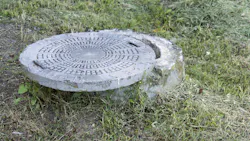
There may be hundreds or even thousands of feet of stormwater infrastructure beneath your community that nobody has looked at in years. Some of it may not be exactly where the plans say it is. Structures may be buried beneath years of soil, vegetation, landscaping or pavement. Pipes may have been repaired, modified, connected or abandoned without those changes ever making it onto the latest drawings. Other portions of the system may have been quietly deteriorating for decades. The unsettling part is that everything can appear perfectly normal from the surface.
Then a depression appears beside a roadway. A catch basin that has always drained begins holding water. A sinkhole develops between two homes. A pond remains unusually high long after rainfall has ended. An outfall begins washing away. A contractor opens a drainage structure and discovers a pipe connection nobody knew existed. Suddenly, a seemingly simple question becomes surprisingly difficult to answer.
What is actually underneath this community? For property managers, HOA boards, municipalities, commercial properties and other stormwater asset owners, answering that question before a failure occurs can be one of the most valuable steps in proactive infrastructure management.
The stormwater system is much larger than the pond
When people think about their community’s stormwater infrastructure, the most visible components usually receive the most attention. They know the pond. They recognize the roadside ditch. They see the catch basins along the street and perhaps know where the large outfall is located at the back of the property. Those visible assets may represent only a fraction of the overall drainage system.
Below the surface can be an interconnected network of pipes, junction structures, catch basins, manholes, underdrains, control structures, culverts and connections transporting runoff across the property. Water entering a catch basin beside one road may travel hundreds or even thousands of feet before reaching its ultimate discharge point. Along the way, that water may pass beneath roads, between homes, through multiple structures, across drainage easements, into a pond, through an outlet control structure and eventually beyond the community entirely.
Every one of those components matters. Every connection also represents another location where sediment, deterioration, obstruction, structural failure or an undocumented modification could affect the performance of the larger system. That is why assessing stormwater infrastructure requires much more than walking around a pond. The system has to be understood as a system.
The map and the ground don’t always agree
Construction drawings and as-built plans can be extremely valuable during a stormwater assessment. Whenever they are available, we want to see them. They can provide pipe sizes, materials, elevations, drainage areas, structure locations, easements, outlet configurations and important information about the original intent behind the system. But plans tell us what was designed or documented at a particular point in the property’s history. The field tells us what exists today.
In an established community, decades may separate those two stories. During that time, roads may have been resurfaced, utilities installed, landscaping changed and drainage patterns altered. Structures may have settled or become buried. Pipes may have been repaired or replaced. Emergency work may have occurred. Swales may have been reshaped. New development may even have connected into existing infrastructure. Sometimes those changes are carefully documented. Sometimes they are not.
Occasionally, a field assessment reveals something that simply does not match what appears on the available plans. That does not make the plans useless. It makes field verification essential.
Communities lose institutional knowledge
There is another challenge that rarely appears on an engineering drawing. People change. HOA boards rotate. Community managers move to other properties. Maintenance supervisors retire. Contractors change. Municipal staff members move into different roles. Residents who remember previous drainage work eventually move away.
A repair performed 15 years ago may have been completely understood by everyone involved at the time. Fifteen years later, there may be nobody left who remembers why the work was performed, what was discovered during excavation or whether additional concerns were identified. The infrastructure remains, but the knowledge disappears.
This is how communities can eventually inherit drainage systems with surprisingly limited information about what they actually own, what has already been repaired, what requires recurring maintenance and which deficiencies have been developing over time. A stormwater system should not depend entirely on someone’s memory. It should have a record.
Every structure is part of a larger story
A catch basin is not just a catch basin. It receives water from somewhere, and it sends that water somewhere else. The same is true for nearly every component within a drainage network. When Ecological Improvements evaluates a stormwater system, we are not simply asking whether an individual structure appears damaged. We are trying to understand how that structure participates in the larger movement of water across the property.
Assessing a structure means asking where the water comes from, where it is supposed to go, what infrastructure it passes through along the way and what happens if that component loses capacity. It also means confirming whether the system observed in the field actually matches the system everyone believes exists. Those questions become especially important because the location where a stormwater problem becomes visible may not be where that problem originated.
A flooded roadway could be influenced by a restriction farther downstream. Sediment repeatedly accumulating inside one structure may be entering the system from an upstream erosion source. A pond holding an abnormal water elevation may have an outlet restriction. An eroded discharge point may be responding to concentrated flow generated hundreds of feet away. Stormwater does not care about convenient property management boundaries. It follows elevation, available conveyance and hydraulic pathways. Our job is to follow the evidence.
Sometimes the most important infrastructure is the infrastructure you can’t see
A surface assessment can tell us a tremendous amount. Erosion patterns, sediment deposits, staining, settlement, vegetation changes, exposed structures, high-water indicators and drainage pathways all provide information about how a system has been functioning. Eventually, however, an investigation may need to go underground.
That is where CCTV pipe inspection becomes particularly valuable. A camera traveling through stormwater infrastructure can reveal conditions that cannot be confidently evaluated from the surface, including sediment accumulation, root intrusion, separated joints, cracking, deformation, obstructions, infiltration, unexpected connections and changes in pipe material. It can also help answer one of the simplest and occasionally most difficult questions in a stormwater investigation.
Where does this pipe actually go? That information can completely change the next decision. Imagine excavating a roadway because everyone assumes a pipe has collapsed, only to discover that the actual problem is a localized sediment obstruction. Consider repeatedly cleaning a catch basin without recognizing that material is continually entering the system from an upstream erosion source. A community may even be preparing to replace an entire drainage line when the significant deficiency is isolated to one section.
Investigation before excavation can reduce uncertainty. Reducing uncertainty is one of the primary purposes of a professional stormwater assessment.
A buried structure can become a big problem
Stormwater structures also have a way of disappearing. Years of landscaping, soil accumulation, sediment deposition, road improvements, vegetation growth or property modifications can obscure infrastructure that was once accessible. In some cases, a structure shown clearly on an older plan may be surprisingly difficult to locate in the field decades later.
A structure that cannot be located cannot easily be inspected. A structure that cannot be inspected cannot be confidently maintained. Infrastructure that cannot be maintained has a greater chance of becoming known only when something goes wrong. This is why locating and documenting assets can be just as important as documenting deficiencies.
The objective is to establish a usable picture of the system: what assets exist, where they are located, how they connect, what condition they are in and whether they can be accessed for future inspection and maintenance. Once established, that baseline becomes increasingly valuable every year it is maintained.
Then there is the question nobody wants to ask
Finding infrastructure is one thing. Determining who owns it can be another matter entirely. Stormwater systems often cross multiple boundaries. A drainage network may include infrastructure within HOA common property, municipal rights of way, private lots, drainage easements, adjacent developments, golf courses, commercial parcels or other jurisdictions.
A pond may belong to one entity while portions of the infrastructure feeding it belong to another. A pipe may begin within a community and discharge outside its boundaries. An easement may provide drainage or access rights without necessarily answering every question about maintenance responsibility. Those distinctions become extremely important when a deficiency requires significant repair.
Before spending substantial money, a property owner should have the best possible understanding of the infrastructure involved, its location, its function and the applicable ownership or maintenance responsibilities. That often requires combining field information with available plats, easements, plans, agreements and other records.
What happens when nobody knows?
Unknown infrastructure rarely creates urgency while everything is functioning. The urgency arrives when it stops functioning. At that point, nobody may be sure where a line goes, whether there is another manhole, why the structure shown on the plan can’t be found or where the pond discharges. Questions follow about whether a pipe was previously repaired, whether an outfall belongs to the community, whether a contractor can access it and whether the pipe is blocked, damaged or collapsed. Then come the questions of what is upstream, what is downstream and who is responsible.
Every unanswered question consumes time during the exact moment when time becomes valuable. That is the difference between reactive stormwater management and proactive stormwater management. One waits for infrastructure to introduce itself through failure. The other goes looking for it first.
Turn an underground mystery into an asset inventory
A stormwater asset inventory that identifies specific assets, locations, connections, conditions, photographs, maintenance needs and repair histories changes the conversation. Over time, plans, photographs, field assessments, CCTV footage, repair documentation, structure inventories and recurring inspections create something extremely valuable: institutional knowledge that stays with the property.
That information makes future assessments more effective. It makes maintenance scopes clearer. It gives contractors better information before work begins. It supports budgeting and capital planning. It helps identify recurring problems and allows future boards and property managers to inherit more than infrastructure. They inherit an understanding of it.
Don’t wait for a failure to introduce you to your own infrastructure
The worst time to learn your stormwater system is during an emergency. A proactive assessment creates something far more valuable than a list of problems. It creates knowledge and direction.
Beyond locating assets and documenting their condition, a thorough assessment separates what requires routine maintenance from what should be monitored, what warrants additional investigation and what requires corrective action. It also identifies what should become a capital priority before another major storm makes that decision for you.
At Ecological Improvements, we combine available plans and historical information with field assessments, infrastructure tracing, condition documentation, CCTV investigation and practical corrective recommendations to help clients understand the stormwater systems they are responsible for managing. The goal is not simply to identify deficiencies. It is to give the client a clearer understanding of the infrastructure, establish priorities and develop a practical path forward. Because stormwater infrastructure should not remain an underground mystery until the day it fails.
About the Author
Joseph Garavelli
Joseph Garavelli is the founder and senior environmental consultant at EcoTactics, specializing in erosion control, stormwater systems, and water quality solutions throughout South Carolina. He also provides consulting support for Ecological Improvements on environmental and infrastructure-related projects.