About the author: Nicole Seuffert is a business development/marketing coordinator for RGS Associates Inc. Seuffert can be reached at [email protected] or 717.715.1396.
Landis Homes—a continuing care retirement community nestled within the pastoral landscapes and preserved farmlands of Lancaster County—recently embarked on an expansion of its South Campus, which focused on the undeveloped 39-acre portion of its 114-acre property. As stewards of its surroundings, the community believes that environmentally sensitive areas must be maintained, protected and conserved. These values have proven to be influential in the design and development of the remaining campus area.
RGS Associates and LandStudies guided Landis Homes in restoring Kurtz Run—a stream that runs through the eastern portion of the property, which was degraded by centuries of human activity such as timber harvesting, milling and farming. These activities carried eroded soils into lowlands and disconnected the stream from its natural floodplain substrate.
“With stewardship as a guiding value of the Landis Homes community, the primary goal of this restoration project was to vastly improve stream function and the site’s ecological biodiversity while making efficient use of the remaining land,” said Linford Good, vice president of marketing and planning for Landis Homes. The project would address traditional infrastructure challenges associated with new storm water management regulations and the expansion of the retirement community.
The Project Begins
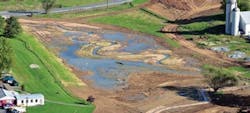
In August 2012, earthmoving equipment removed more than 27,000 cu yd of legacy sediment (equivalent to approximately 40,000 tons of soil, or 1,800 large dump truck loads) from the Kurtz Run stream corridor to be deposited in other stabilized, upland areas of the Landis Homes community.
The project included the elimination of a manmade pond that was constructed to provide fire protection before public water had been extended to the site. The pond was in jeopardy of breaching its embankment due to excessive streambank erosion. “Early conversations between RGS Associates and LandStudies over how to address this condition eventually led to the far-reaching strategy of undertaking an entire floodplain restoration and legacy sediment removal project,” said Mark Hackenburg, principal at RGS Associates.
The Permit Process
To implement the campus expansion and floodplain restoration projects, several approvals and permits were necessary from local, state and federal government agencies. In order for construction to commence, initial zoning and land development approvals were required by the local municipality. Due to extensive restoration work within the floodplain, approvals also were required from the Lancaster County Conservation District (LCCD), the Pennsylvania Department of Environmental Protection (PA DEP), and the U.S. Army Corps of Engineers (USACE).
The Water Obstruction and Encroachment Permit addressed both Title 25 PA Code Chapter 105 and Section 404 of the Federal Clean Water Act for impact to waters of the U.S. and waters of the Commonwealth. The PA DEP was responsible for the state authorization and the USACE handled the federal authorization through a single application.
During the initial stages of the restoration design, RGS and LandStudies worked with the local municipality, the LCCD and the PA DEP to identify the significant environmental benefits that accompany the restoration effort. In order to obtain some of the plan approvals, RGS sought modifications to 10 of the township’s storm water management ordinance requirements and one modification to the township’s floodplain ordinance in order to incorporate innovative storm water management systems and techniques.
Storm Water Plans
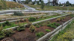
To accommodate project schedules and address the requirements of this project, storm water management plans were prepared utilizing conventional detention basins, along with BMPs such as rain gardens, bioswales and porous pavement. These systems were designed to provide 57,000 cu ft (approximately 425,000 gal) of groundwater recharge for each two-year storm event. In addition, the floodplain restoration is expected to treat approximately 4.2 sq miles of upland drainage area while providing approximately 154,000 cu ft (approximately 1.1 million gal) of groundwater recharge for each two-year storm event. The storm water management plans were submitted reflecting conventional detention facilities. The approval process always considered their removal once the floodplain restoration project was completed, stabilized and fully functional.
Multiple agencies were involved in the review and approval process, as the project was connected to a number of permitting requirements. The National Pollutant Discharge Elimination System (NPDES) permit was the most complex approval obtained. The PA DEP handles administration of the NPDES permit program with oversight from the U.S. Environmental Protection Agency. Within this regional jurisdiction, however, the PA DEP has delegated the administration of NPDES permits to participating conservation districts. The local organization that reviewed the Erosion and Sedimentation Control (E&S) Plan required for NPDES permit approval was the LCCD. The E&S plans, like the storm water management plans, include a conventional approach to the site’s storm water management solutions. Once the restored areas of the floodplain are functioning and following the quantification of its storm water benefits, the municipality will determine if the floodplain can function as a means of storm water management.
The ultimate desire of Landis Homes is to build additional residential units where the conventional storm water basins are currently located. Landis Homes is in the process of amending its land development plans to reflect the intended use of the restored floodplain for storm water management purposes. Prior to the addition of any residential units, “a major modification of the NPDES permit will need to be submitted for review in an approach similar to, and concurrent with, the revised land development plan that will be submitted to the township,” said Benjamin J. Ehrhart, P.E., director of design for LandStudies.
The floodplain restoration initiative is projected to provide environmental benefits such as enhanced terrestrial and aquatic habitat, increased floodwater storage potential, improved infiltration, reduced streambank erosion and increased water quality benefits both on site and downstream. Nutrient and sediment load reductions within Kurtz Run will contribute to the broader Chesapeake Bay improvement initiatives; however, these have yet to be fully quantified.
The final result of the project will be a more efficient utilization of land within a county and township designated growth area, as well as vastly improved water quality over that of traditional storm water management techniques. Future campus growth also will be poised to efficiently utilize this infrastructure improvement, which hopefully will result in a long-term economic net gain associated with the restoration project.
Download: Here


