Reviving a River
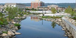
The rapid growth and industrialization of Yonkers, N.Y., in the second half of the 19th century took its toll on the Saw Mill River, which served sawmills, gristmills and carpet mills as both a power source and a receptacle for waste materials. By the 1920s, the heavily polluted waterway was regarded more as a public burden than an asset. In response, the U.S. Army Corps of Engineers constructed a massive flume that carried the river beneath the city at Larkin Plaza. Eighty years later, the city decided to restore this geographical resource by “daylighting” the river—that is, returning it to its natural, open-air state, and making it the centerpiece of a public park.
Paulus Sokolowski & Sartor (PS&S) of Warren, N.J., was selected as the design engineer for the project, which was the brainchild of former New York Gov. George Pataki and has been championed by former Yonkers Mayor Phil Amicone.
“When we first solicited proposals for how best to turn the Saw Mill River from a liability into an asset, PS&S was by far the most creative,” Amicone said. “They shared a very exciting vision of how the river could be leveraged for maximum impact to the community. More importantly, they thoroughly understood and addressed the many complex engineering challenges associated with the project.”
As the design engineer, PS&S was responsible for creating a park with maximum aesthetic appeal around a complex, functioning river system. This required careful consideration of hydrology; riverine wildlife migration and habitat requirements; how to preserve historic and community resources; pedestrian safety; river flow and tidal influence; flood control; storm water management; landscape design; and other essential aesthetic concepts. The final design included the maintenance of the flume to carry the larger storm flows, and incorporated appropriate hydrophytic and indigenous terrestrial vegetation with active debris netting chambers to manage and improve the river’s water quality before it entered the Hudson River. As a result of this project, Larkin Plaza, formerly utilized primarily for parking, provides significant community and ecological benefits, and is itself an objective in Yonkers’ plan for social and economic growth.
Challenges: Modeling the Flow
From a design and engineering perspective, this project created a variety of challenges related to both park aesthetics and a complex, functioning hydrological system. In order to accurately predict the river flows through the varied flow characteristics of the new river elements, including the pools, riffles and weirs, PS&S utilized flow prediction models.
Initially, PS&S examined the range of the river flows from available data sources, including Federal Emergency Management Agency studies, the Army Corps of Engineers and a U.S. Geological Survey gaging station in Yonkers. The boundary conditions for the river flow identified a low flow condition of 40 cu ft per second (cfs) and the extreme 100-year event of 1,910 cfs. While confined to the flume, the river flood threat was substantially mitigated; uncovering the watercourse removes, to some extent, the protection of the flume. The low end of the flow range posed a second challenge: To fulfill its aesthetic role as the focal point of the public space, the river needed sufficient volume to create sensory interest.
The concept for the project was to maintain the existing flume to carry the large storm events and control flow to the daylight portion of the river for the base flow and metered storm events. This was accomplished within the confluence chamber, which was analyzed utilizing HEC-RAS and Hydraflow. Various model scenarios were developed to establish the appropriate geometry of the diversion structure within the chamber. An iterative analysis was performed for varied dimensions to determine the most effective diversion characteristics to shunt all of the base flow to the daylighted section of the river, while incorporating a bypass for flows that exceed base condition and climb during storm events to more than 200 cfs. The diversion structure developed would continue to allow flows to the daylighting during all storm events but carry the bulk of the large storms within the existing flume.
Following the separation of the flow, the restricted flow to the daylighted portion of the river was analyzed to maintain the desired results of a visual and audible centerpiece throughout the varied, now restricted flow rates of 40 cfs to the high flow of 200 cfs. An additional design consideration entered the equation with a tidal influence at the confluence of the daylighted river. Within the corridor to be daylighted, the Saw Mill River makes the transition from a freshwater system to the brackish water of the Hudson River. As the tidal influence also would affect the flow regime within the daylighted waterway, hydraulic design of the daylighted portion also would be controlled by the flow characteristics of the Hudson River. It was important to maintain a strong river presence during dry weather and control the flow during wet weather events while respecting the daily tidal influences. The combination of pools, riffles and weirs was developed to incorporate a number of visual and sensory events for the public. The hydraulics of these events were analyzed using HEC-RAS software.
In order to capture the full range of potential events, the HEC-RAS analysis included a full range of storm events and flow rates while applying the varied tidal conditions at the confluence with the Hudson River. The hydraulic river model consisted of the various river daylight elements, including the initial daylight pool and weir, upper pool, riffles, lower pool, tidal weir and tidal pool. The model for the daylight reach was evaluated for base flow, and 10- and 100-year storm events. Additionally, each of these events was modeled under downstream boundary conditions for the varied tidal conditions from spring low tide, low tide, slack tide, high tide, spring high tide and the 100-year storm event elevation.
The daylight river water surface elevation under each of these flow scenarios, as well as the flow velocities produced within the daylight river, were identified and analyzed for purposes of slope armoring, maintaining visibility in low flow and development of the park elements. The extreme event producing the highest water surface elevation was not coincidental with the maximum velocities within the new river system. Examining the entire range of potentially coincidental events with tidal events allowed for the understanding of maximum water surface elevations and maximum flow velocities dictating the details of the various elements of the new daylighted river system.
The velocities developed within the model then were utilized to design the riprap slope protection along the length of the river. The water surface elevations determined through the modeling exercise established the minimum elevations of the pedestrian bridge and surrounding park walks and features. On the opposite end of the flow regime is the low flow (base flow) condition; under low-tide cycles, there was a concern the river would “disappear.” At minimum flow, the stepped design of the channel takes advantage of the sloping topography and employs a section of riffles—a short stretch with a large grade differential that increases water speed—to maintain the flow and audibility necessary to draw the attention of park visitors. The pools serve as a visual presence of the river during low-flow conditions.
Positive Results
Construction commenced in December 2010 and was nearly complete in September 2012. The hydraulic modeling predictions have proven to be quite accurate through several significant precipitation events, including Superstorm Sandy. Public reaction to the New River Park has been overwhelmingly positive. The daylighting has created a point of interest—a destination rather than a pass-through—that has and will continue to attract people to the neighborhood and bring business to surrounding establishments. In bringing people to the water, the city will again harness the power of the river that once ran the mills.
Download: Here


