When natural disasters strike, much focus and attention is placed on the immediate impact on communities. However, full recovery is an ongoing process. In the short-term, recovery efforts focus on restoring operations and functions, while, in the long-term, focus is on reconstructing systems and improving resilience for the future. Moving through the recovery continuum can take years. Following a major flooding event in 2013, a decade of recovery for Boulder County, Colorado, began.
A flood of “Biblical” proportions
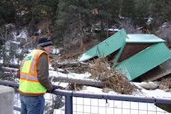
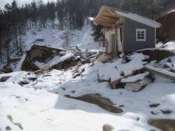
Beginning on September 11, 2013, a slowmoving cold front stalled over Colorado and clashed with warm humid monsoonal air from the south, prompting heavy rain and catastrophic flooding along Colorado’s front range. The water spread across almost 200 miles and affected 17 counties. The flooding was described as “biblical” by The National Weather Service, and thousands of residents needed to be evacuated by land and air. The hardest hit locale was Boulder County, which recorded more than 18 inches of rain over a matter of days — an amount notably comparable to the county’s average annual precipitation. In the aftermath, Boulder County’s waterways were drastically altered. Large debris, channel migration and sediment aggradation and degradation within creek channels decreased the stability of the county’s eight watersheds and increased the vulnerability of the adjacent communities to future floods. Additionally, more than 140 miles of road, 31 bridges and culverts, and 188 private access crossings were damaged or destroyed. Estimated damage to public infrastructure rose to $128 million.
Immediate response
Following the flooding, then-Governor John Hickenlooper set an aggressive goal: reopen all highways by December 1, 2013. With the clock ticking, the Colorado Department of Transportation (CDOT) partnered with Michael Baker International. The firm served as owner, advisor and designer in the rebuilding of State Highway 7, one of the main routes connecting Lyons, Colorado, and Estes Park, Colorado, that suffered major damage in the flood along 11 miles of roadway and streams. Over the next 57 days, a herculean effort took place to open the roads even before the governor’s deadline. This included a team of 75 individuals, 60 pieces of equipment, 171,000 cubic yards of fill, 27,000 tons of road base, 14,600 tons of asphalt and 9,300 linear feet of concrete barrier. In addition, the team assessed 131 culverts and infrastructure sites, with 27 culverts ultimately repaired and replaced.
Short-term recovery
With immediate response completed, Michael Baker began supporting Boulder County with recovery efforts. The team took a programmatic approach to restoration and resiliency for both the infrastructure and stream networks. Boulder County was severely impacted by flooding with widespread erosion, deposition and channel migration. This event wiped out infrastructure networks, dramatically modified the flood risk profile, exposed homes and roadways to imminent threat of streambank erosion, significantly damaged ecological and biological functions, and left the creeks in a state of instability. Several questions needed to be answered quickly. Most immediately and importantly, how did the flood risk change because of this event? The region was trending toward a historic snowpack, which meant the potential for equally historic spring runoff when melting began. With the typical flood season beginning in May, the Michael Baker team again needed to act quickly.
The team prioritized cleanup in the most vulnerable areas to reduce the probability of additional flood damage moving forward. Team members walked every mile of stream to assess the conditions, and data was collected from residents, with an online viewer created to summarize the findings. The team utilized LiDAR technology, a remote sensing method that uses light in the form of a pulsed laser to measure ranges (variable distances) to the ground, to compare the post-flood status to the pre-flood terrain that had been previously captured. Utilizing this data, the team identified 213 high-hazard sites and projects. Before May 1, 2014, 133 of the highest-priority projects were completed before the spring runoff. These included 32 bank stabilization efforts, 81 woody debris removals, three berm constructions, seven conveyance restorations, two stream redesigns and realignments, two culvert assessments and six high-hazard home projects. These efforts ensured that no additional damage occurred during the spring runoff.
Long-term recovery
Looking to the future, a Comprehensive Creek Planning Initiative (CCP) was initiated by Boulder County to address the vulnerabilities in the county’s watersheds after the 2013 flooding event. The project was designed to mitigate immediate flood hazards and lay the foundation for long-term watershed recovery by developing multi-disciplinary watershed-level master plans for flood-impacted watersheds. As part of the CCP, Boulder County created five watershed master plans, and engaged Michael Baker International to develop the master plans for the St. Vrain watershed and the Fourmile Creek watershed. These plans established a long-term vision for a sustainable watershed by providing post-flood analysis of flood risk. The analysis facilitated key decisions about creek alignment and helped identify actions for stream restoration and flood risk management. The master plans also identified projects and potential funding sources.
This customized planning approach took outreach to the communities to address individual watershed needs and create projects with short- and long-term benefits. The master plans developed strategies with multiple local and regional benefits, including flood mitigation and risk reduction, stream stability, infrastructure and structure protection, ecosystem improvements, recreational opportunities, and historical preservation. The plans were completed in 2014 and adopted by the Boulder County Board of Commissioners in February 2015.
The funding mechanism for this work was the U.S. Department of Agriculture’s Natural Resources Conservation Service's (NRCS) Emergency Watershed Protection (EWP) Program. With collaboration and guidance from Colorado Water Conservation Board (CWCB), who was managing the EWP program statewide, Michael Baker laid out a nature-based ecosystem restoration plan.
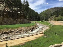
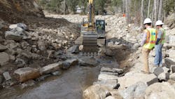
Michael Baker’s work has served to restore the entire ecosystem of the affected area. To restore and enhance the resiliency of the stream network, Michael Baker led a multidisciplinary team of engineers, ecologists, outreach specialists, fish biologists, and environmental specialists to design, assess environmental impacts, permit and oversee construction. Key aspects of the project involved performing geomorphic, sediment transport and hydraulic analyses. Elements of the design for the resulting project included grade control structures to stabilize the stream profile, riffle-pool and step-pool sequences to support fish habitat, and reconnection to the adjacent floodplain to support ecological functions, water quality and overall stream health. Designs were completed only to the 60% level, requiring a quasi-Design-Build delivery / field-fit approach for the construction phase. To ensure Federal Emergency Management Agency (FEMA) regulatory compliance, Michael Baker created a new floodplain compliance check process and performed surveys immediately after construction of key elements. The firm also updated hydraulic models within hours of receiving the survey data to ensure compliance with floodplain permitting.
Once construction was complete, Michael Baker handed over the Operation & Maintenance phase of the project to the county by creating a custom, tablet-based application using Boulder County’s ArcGIS online map and collector app. Using designs, alignments, photographs and performance criteria, Boulder County is now able to perform regular assessments and adaptive management of the restored streams using their own staff and IT systems. For wetland mitigation monitoring, Michael Baker’s subcontractor, Pinyon Environmental, coordinated a multiyear mitigation monitoring effort with the U.S. Army Corps of Engineers (USACE).
A decade of recovery
Coordination of both infrastructure and stream projects over a decade required extensive coordination with multiple stakeholders for this high-impact program. Initial community engagement involved facilitating kickoff meetings attended by more than 650 residents to discuss more than 3,000 reports of damage along 90 miles of streams. The resulting design and construction projects required extensive agency coordination with Boulder County, City of Boulder, CWCB, Colorado Department of Public Health & Environment (CDPHE), FEMA, Department of Housing and Urban Development (HUD), USACE, the U.S. EPA, U.S. Fish and Wildlife Service (USFWS) and Colorado Parks and Wildlife (CPW), among others. The CCP initiative has now transitioned to the Creek Recovery & Restoration Program (CRR). This program continues the long-term recovery effort by seeking funding for restoration projects, overseeing project implementation, and continuing to partner and coordinate with stakeholders and residents in the community.
For Michael Baker, what began with a short-term consulting contract extended into a decade of partnership toward recovery and the ultimate goal of improved resilience. Today, the firm continues to support Boulder County’s recovery and resilience efforts through floodplain permitting and floodplain mapping. Under this ongoing on-call contract, Michael Baker has provided high quality deliverables within established schedules, some as short as two days, on more than 120 task orders under Boulder County’s Floodplain Program since 2014. Ten years in the making, the project will serve as an example of adaptation and resilience over the next decade and beyond.
About the Author
Chris Tagert
Chris Tagert, P.E., CFM, is a regional practice lead for water at Michael Baker International.
Kevin Doyle
Kevin Doyle, P.E., is the Department Manager of Water at Michael Baker International.


