Navigating complexity in major drainage infrastructure
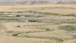
As large campuses, industrial parks, mixed-use districts and logistics hubs continue to expand, major drainage infrastructure has become one of the defining forces behind whether development succeeds on schedule and within budget. Far beyond a technical afterthought, drainage corridors now influence entitlement risk, land yield, stakeholder confidence and long-term site value. On projects where tributary basins exceed 100 acres, natural conveyance requirements, floodplain constraints and environmental oversight can fundamentally reshape what is possible on the ground.
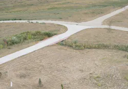
The most successful project stakeholders recognize that drainage is no longer simply an engineering exercise. It is a strategic planning challenge that necessitates regulatory foresight, early coordination and a design mindset capable of transforming infrastructure from a perceived limitation into a long-term asset that provides ecological uplift and community benefit. That shift in perspective is increasingly separating projects that stall in approvals from those that move forward with confidence and success. Here's how.
Designing around water, not against it
One of the greatest tensions in large-scale development lies in balancing buildable land with the need to preserve upstream flow conveyance. When a site contains a major drainage corridor, developers often face pressure to maximize program area. At the same time, municipalities require that the system remain maintainable, functional, visible and increasingly open to the landscape. This is where early master planning becomes indispensable.
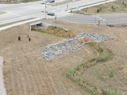
By identifying drainage constraints during due diligence rather than later in entitlement, stakeholders can organize roads, utility spines and building pads around water movement instead of forcing redesigns after layouts are established. That early understanding also opens the door to more integrated site strategies, including expanded conveyance zones beyond the primary channel that offset impacts without increasing downstream flood risk.
Just as important, open-channel systems are increasingly proving their value beyond compliance. What once might have been viewed as "lost land" can become a visual amenity, ecological corridor or organizing spine for the entire campus. In industrial developments, data centers and warehouse districts, these naturalized corridors create surprising moments of landscape relief while still preserving development goals. The result is a site that performs better, both hydrologically and hydraulically, while delivering a stronger user experience and broader community acceptance. That design-first approach also positions the project more favorably as it enters the next major challenge: permitting.
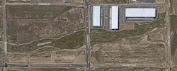
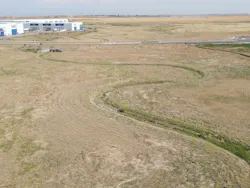
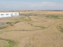
For example, on a recent drainage infrastructure project in Colorado, approximately 7,500 linear feet of High Functioning Low Maintenance Stream (HFLMS) improvements were designed to re-establish a stable channel while supporting future industrial development. The effort included custom roadway crossings, a regional flood control facility and extensive hydraulic analysis to balance flood conveyance, long-term geomorphic stability and reduced maintenance demands. By treating the corridor as critical infrastructure rather than leftover space, the project enhanced floodplain function while creating a resilient framework for long-term growth.
Why permitting often defines the schedule
For many large developments, the true critical path is not construction. It is floodplain and environmental approval. Where regulatory floodplains intersect a site, federal and local agencies may require permits before any grading or channel modifications begin. These reviews can easily add a year or more to the front end of a project, and the process does not end once construction is complete. Post-construction verification is often required before certificates of occupancy can be issued, creating significant downstream schedule risk if the built work deviates from approved plans.
The most effective strategy is often to avoid unnecessary federal review where local pathways exist. Projects that can demonstrate no-rise or no-adverse-impact conditions may be able to pursue municipal floodplain approval rather than a full federal process. This requires rigorous modeling and disciplined design boundaries, but the time savings can be substantial. In practice, the difference can mean months, or even more than a year, of schedule recovery during entitlement.
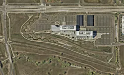
The value of this approach was demonstrated on another Colorado drainage improvement project, where the team advanced permitting through a pre-project no-rise certification that documented no adverse impacts to flood elevations. By carefully defining design limits and supporting them with detailed hydraulic modeling, the project streamlined approvals while positioning the team for a subsequent FEMA Letter of Map Revision process following construction.
Equally important is early engagement with floodplain administrators, adjacent landowners and municipal review staff. These conversations surface hidden concerns around timing, flood elevations and cost exposure before they become formal objections. Once the entitlement path is established, the next determinant of success becomes the human system surrounding the project.
The real complexity: Managing the stakeholder web
Major drainage infrastructure projects rarely move through a single review channel. Instead, they require alignment across a dense network of agencies, utilities, transportation authorities, environmental regulators, floodplain officials and nearby property interests. That complexity is often the most difficult part of the work.
Municipal planning departments may focus on entitlement milestones, while transportation agencies prioritize roadway interfaces, environmental reviewers assess wetlands and habitat impacts, and utility providers scrutinize crossing conditions. Add adjacent property owners, airport authorities, state transportation agencies and local flood districts, and the timeline can quickly expand. The projects that maintain momentum are typically led by teams that understand not only the regulations but also the personalities, workflows and expectations behind each agency.
Established relationships matter. Knowing who to call, how each agency interprets standards and where flexibility exists can dramatically reduce misunderstandings and review cycles. Just as critical is maintaining transparency across the broader project team so developers, consultants, contractors and agencies remain aligned on both risks and decision points. This coordination challenge is becoming even more significant as environmental oversight evolves.
Large-scale stream and drainage projects also highlight the importance of stakeholder coordination. On the industrial corridor project noted above, coordination with a regional flood control authority, local agencies, roadway stakeholders and FEMA was required to secure a Conditional Letter of Map Revision prior to construction and support final floodplain mapping updates after completion. Maintaining alignment among these parties proved just as important as the technical design itself.
The new reality of environmental review
A major trend reshaping drainage infrastructure is the shift in environmental jurisdiction from federal agencies to state-level oversight. Historically, wetlands and waterway impacts were often governed through established federal review pathways. Today, many states are assuming greater responsibility, creating a more fragmented and often less predictable approval environment. For development teams, this introduces a new layer of uncertainty.
State agencies may have smaller staffs, evolving workflows and less mature permitting standards than their federal counterparts. That means longer learning curves, less predictable review durations and a higher premium on specialized environmental expertise.
The most resilient stakeholders now bring environmental consultants into the project at the same moment drainage due diligence begins. This parallel path allows jurisdictional determinations, wetlands assessments and state-level review strategies to advance alongside master planning, rather than emerging as a late-stage surprise.
As these frameworks continue to shift, realistic schedule assumptions will become as important as technical accuracy. Yet even the strongest approval strategy can still unravel if construction execution does not support it.
Protecting the back end of the process
One of the most overlooked risks in drainage infrastructure is the gap between approved design intent and field-built reality. Even small grading deviations, channel geometry shifts or changes in conveyance can create problems during final floodplain verification. When those issues are discovered only after substantial completion, they can delay occupancy, trigger redesigns or require costly field corrections.
The most effective solution is phased verification during construction. Rather than waiting for a final as-built survey, high-performing teams conduct sectional earthwork checks and interim surveys throughout the grading process. This incremental approach allows discrepancies to be corrected in real time, preserving schedule certainty and reducing risk at the certificate-of-occupancy stage.
Close collaboration with contractors is essential here. When project team stakeholders remain actively involved during construction administration, they can quickly resolve field questions and ensure that drainage infrastructure is being built in a way that supports final approvals. That discipline reinforces a broader truth about this project type.
Infrastructure as a development asset
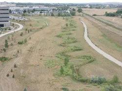
The future of large-scale drainage design lies in reframing infrastructure as an amenity, a resilience strategy and a placemaking opportunity. Thoughtfully designed stormwater corridors can improve ecological performance, enhance public perception, create landscape identity and support long-term value for both private owners and surrounding communities. What once constrained development can now become one of its most memorable features.
Recent Colorado examples illustrate how these principles translate into built outcomes. One project reconstructed approximately 2,500 linear feet of drainage channel to improve hydraulic performance and channel stability while integrating transportation infrastructure, low-water crossings and energy-dissipation features. Another transformed a major stream corridor into a durable, low-maintenance system that now serves as the backbone for future development. In both cases, drainage infrastructure became more than a compliance requirement; it became a long-term asset supporting resilience, watershed performance and future economic growth.
As environmental regulations continue to evolve and entitlement pressure intensifies, the projects most likely to succeed will be those that address drainage systems early, coordinate stakeholders relentlessly and design with both compliance and experience in mind. In that sense, major drainage infrastructure is no longer just a technical hurdle. It is increasingly one of the clearest measures of whether a development team can turn complexity into long-term value.
About the Author
Ryan Byrne
Ryan Byrne, PE, CFM, LEED AP, is Principal, Civil Engineering, with Martin/Martin Consulting Engineering. He can be reached at [email protected].