Dam Rehabilitation in North Carolina
After consistently being named one of the best communities in which to live in the US, the city of Apex, NC, finally reached the #1 spot in 2015, according to Money magazine.
Apex, a suburb of Raleigh, is home to some 44,000 residents. It is also home to the Lake Castleberry Dam, built more than 65 years ago. Despite its beautiful surroundings, the structure was in dire need of repair.
The lake and the surrounding property were purchased by a developer, with the plan to build a single-family residential subdivision.
“They desired to keep the lake as an amenity and as a part of the stormwater management system,” says Blake Ball of engineering firm WithersRavenel.
“According to State of North Carolina records, the dam was originally built in 1950. The dam, like many private dams, suffered from neglect. There were many large trees—14- to 20-foot pines, oaks, and sweetgums—growing on the crest and downstream slope of the dam. The principal spillway exhibited severe erosion, and the emergency spillway was overgrown with trees and underbrush. The original drain valve was broken, and was not even found until the lake was drawn down to begin the project,” he says. “Our initial assessment found erosion and undercutting along the crest and downstream face of the dam due to overtopping during large storm events. The condition of the dam as it existed could have been a liability to our client, and to the homeowners’ association once the subdivision was completed and the dam turned over to them.”
The WithersRavenel firm notes that North Carolina dam safety regulations require slopes to be protected against erosion by wave action, and the crest and downstream slope need to be protected against erosion from wind and rain. Riprap and other erosion protection must be provided over the full range between the lowest drawdown elevation to at least 2 feet above full normal pool.
So, although there was a need to protect and stabilize the upstream slope of the dam, the landowner considered the lake to be the signature feature and amenity for the development. Therefore, although riprap is a traditional approach for dam remediation, the goal was to provide options that would present a more attractive appearance to the highly visible upstream face of the dam. Easy maintenance was also an important part of the equation.
In addition, there were wetland and stream buffer considerations for the project, as well as a desire to maintain the existing fish population in the lake.
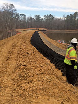
Placing the Geoweb on the dam
To attain these goals, the design team at WithersRavenel turned to Staci Smith with ACF Environmental for suggestions of alternative armoring solutions. Smith, in turn, worked with the engineering team at Presto Products to come up with a design incorporating Presto’s Geoweb cellular confinement system.
The team chose the Presto GW30V6 product, which is a 6-inch-deep, mid-size cell anchored with 24-inch rebar in a three-cell by three-cell pattern, every three cells for the entire width and length of the dam.
“This is an alternative that would work,” says Smith, “combining the aggregate below the water and topsoil and vegetation above the water level to meet the aesthetic requirement, as well as dam safety and ease of maintenance. It was important to have a system that was proven, and a system that had great engineering behind it.”
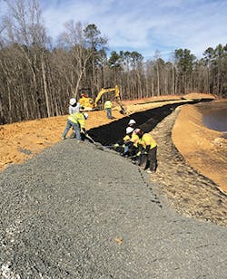
Stone infill (#57 stone) was used below the normal water level, sized to handle the anticipated wave action it would face. This stone fits easily into the individual cells but leaves enough void space to fill in with fines that can support vegetation underwater as well.
Although the state dam safety regulations only require protection 2 feet above the normal lake water surface, for this project the Geoweb was extended to an elevation of 3 feet above the normal lake level to allow for regular fluctuations. “This extra foot will be engaged frequently,” says Smith.
Ball explains, “Prudent design—and the regulations—required us to include a means to protect the upstream dam face from wave erosion. Permanent turf reinforcement matting, riprap, and the cellular confinement system were considered as solutions. The cellular confinement system was selected because the material would provide immediate protection upon installation and a more aesthetically pleasing finished product.”
Most of the Geoweb system could be installed by hand, says Smith, and no heavy equipment was needed—so even when the weather wasn’t particularly cooperating, the work could still continue.
Adding stone infill
“Almost all dam rehabilitation projects present unique challenges because of the widely varying methods and quality of the initial construction—and the fact that, by the time a rehabilitation is required, there are maintenance and safety issues that need to be addressed,” says Ball. “There were several such issues with this project. Perhaps the greatest challenges involved the weather and somewhat limited access to the work area. An unforeseen benefit of choosing the Geoweb product was the ability to handle the product and the washed gravel fill with small equipment—a skid-steer loader and small track excavator—and hand tools. Transporting and installing riprap in wet, muddy conditions along the 700-foot face of the dam would have been quite a challenge.”
This proved to be an important consideration, since it happened that the Geoweb system was installed through multiple snow and ice storms, making the work site very saturated and difficult to traverse.
Other BMPs were also used at the site. “There are other products used for different areas of the project,” says Ball. “Temporary matting was used on the downstream face of the dam and the upstream face above the cellular confinement system. Permanent turf reinforcement mat was used in the groin ditches and the emergency spillway. Riprap was utilized for velocity dissipation below both the low-flow control structure and the drop spillway.”
There was also quite a bit of cleanup and repair necessary on the dam, he notes. “In addition to the shoreline protection, the rehabilitation of the dam included removing the trees from the dam and emergency spillway, repairing the damage from previous overtopping, and adding additional fill to reinforce the dam and lessen the slope on the downstream face. A new drain and low-flow control structure were added to maintain normal pool and replace the failed drain, and a new concrete drop spillway replaced the eroded principal spillway.”
Ball continues, “To provide a safe work area, protect the integrity of the existing dam, and to satisfy requirements of the dam safety program of the North Carolina Department of Environmental Quality, it was necessary to lower and maintain the lake level at a point below the elevation of the work.”
Now that the work has been completed, Castleberry Lake can contribute to the city’s #1 ranking.
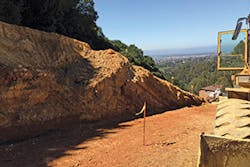
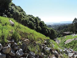
Leona Heights mine site after remediation
Remediation of an Orange Creek
The origins of the Leona Heights Mine in Oakland, CA, date back to the late 19th century. Workers digging postholes on a property in the area thought they had found gold, but analysis showed it was actually iron pyrite, or “fool’s gold.”
However, the pyrite contained enough sulfur to make it profitable to mine the material. A band of pyrite about 10–20 feet wide ran for a length of 3,000 feet along the eastern edge of Oakland, in an area known as the Oakland Hills.
The mine was operational until at least 1913, when a major fire shut down operations. It was closed permanently in 1934. By that time, more than 6,000 feet of tunnels had been dug from the hillside.
Eighty years later, the extent of the damage to the area was revealed in the Leona Heights Sulfur Mine Remediation Initial Study, prepared by LSA Associates in March 2014. It reads in part:
“The closed mine is located in the upper reach of the Leona Creek watershed, and sulfur-bearing mining waste lines the ravine in which Leona Creek flows. The tailings occur in the form of deep localized accumulations or as thin localized pockets overlying bedrock. The site consists of upper and lower mine tailings piles. In the upper portion of the former mine site, the intermittent creek has eroded downward into underlying basement rock through the mine tailings, forming a deeply incised channel. The tailings piles are more porous than the native bedrock, which allows water to erode the material.
“The areas where extensive mine tailings are present are nearly devoid of any vegetation, while the remaining areas of the site are covered with mainly oak and eucalyptus trees…. In areas of transition where the mine tailings appear as a thin veneer, the vegetation is stressed, and there are little to no grasses and/or shrubs present. The calculated volume of tailings present in the project area is estimated at 14,500 cubic yards.”
The report points out some previously identified environmental concerns: “Water flowing over and through the tailings dissolves sulfur, producing acid mine drainage that flows into Leona Creek. In the dry season, the main source of water to the creek is seep discharge on the property. During rain events, runoff from the watershed above the site forms an ephemeral stream that combines with the seep discharge to significantly increase flows, and therefore, increases acid mine drainage to the creek. Water samples from the site were reported at low pH values (about 3.0), resulting in the leaching of heavy metals into the creek. The creek within the remediation site has the characteristic orange color associated with acid mine drainage, and water samples have demonstrated elevated levels of cadmium, copper, mercury, nickel, lead, zinc, and arsenic.”
Leona Creek ultimately discharges into San Francisco Bay, about 4 miles to the Southwest. The California Regional Water Quality Control Board, San Francisco Bay Region, adopted waste discharge requirements for the area and pushed for changes to address the source of acid mine drainage.
The overall project goal of the remediation was to eradicate damage from the sulfur mine and to improve the water quality of both Leona Creek and the area downstream from the site.
To achieve these goals, the board specified, “The project must prevent further erosion of the mine tailings, encapsulate the mine tailings in a manner which isolates the mining waste from stormwater runoff and contact with groundwater, and provide a design for field implementation of creek restoration actions. In order to meet the project objectives, the proposed project would implement the following:
- Remove mine tailings from the creek channel and other adjacent areas where erosion from waste piles has produced a thin veneer of waste;
- Grade and compact tailings and install a subsurface drainage system beneath the compacted tailings to increase stability;
- Cover the consolidated tailings with a geomembrane liner, and a vegetative layer that will isolate the tailings from water;
- Reroute the seep discharge from its current location inside the tailings, to a new discharge point within the creek channel;
- Reinforce steep slopes adjacent to the creek channel to improve stability; and
- Restore the creek channel to accommodate a 100-year design storm, incorporating drop structures reminiscent of natural creek designs on steep slopes that provide for the natural transport of sediment through the creek, minimizing erosion onsite and downstream.”
When project planning began, the civil engineer called in Tensar International to assist with the work. Matthew Doss, Tensar senior regional manager for the western US, explains that once the old sulfur tailings were removed from the creek, Tensar’s job was to identify and design a way to cover up the remaining sulfur and to stabilize the slopes so that the sulfur remained out of the creek and the area’s groundwater.
“The area we reinforced was about 16,600 square feet, primarily with our Tensar UX1600 uniaxial [UX] geogrid material,” he says. “The UX geogrid is a product that comes in rolls with apertures that are about 18 inches long by one inch wide, repeated down the length of the roll. It gets installed in horizontal lifts roughly every three feet vertically. The contractor rolls out the geogrid at the designated elevation, compacts a lift of backfill up to the next geogrid elevation, and then rolls out the next geogrid layer. Then they compact another lift of backfill and repeat this simple cycle as they build their way up the slopes.”
Doss explains how this geogrid differs from standard geogrid that would be used in other applications. “With Tensar UX geogrids, it is the same product that we use for retaining wall applications, but what’s different about this geogrid versus the standard broad spectrum of geogrids in the market is that Tensar UX geogrids are made with high-density polyethylene resin. HDPE is completely inert to aggressive soil environments on the high and low ends of the pH scale—commonly known as hot soils.
“Some of the other geogrid products available in the market are made of polyester, or PET, yarns that require a protective coating and can’t be used in hot soils. PET geogrids wouldn’t be suitable for use in this difficult environment, with the aggressive chemical properties of the site backfill.”
He notes that some of the reinforced slopes are as tall as 60 feet. In addition to the geogrid, erosion control mats were also placed on the face of the slopes. These mats were then hydroseeded to help establish rapid vegetation.
During the remediation effort, Leona Creek was temporarily diverted to allow clear access to the channel. Doss says, “There were tight working conditions, steep slopes, and some aggressive, acidic backfill. These were the site challenges we dealt with.”
The result has been that mine tailings have now been removed from Leona Creek, mining waste has been covered with a geomembrane liner topped with new vegetation, and the metal and sediment load has been significantly reduced in the creek. No more orange water.
