Soil erosion costs billions of dollars in lost agricultural productivity, property destruction, and water pollution each year in the US (USDA 1987). Displaced sediment also reduces channel and reservoir storage for flood control. Often, soil erosion is problematic in areas cleared of native vegetation for agriculture and development, including the Western Cross Timbers physiographic province of north-central Texas. In such areas, soil conservation ponds protect downstream waterways from sediment and other pollutants.
Many conservation ponds occupy north-central Texas; many are nearly 50 years old, and these ponds have become an integral part of the physical landscape.
Cores from conservation ponds may provide insight on the fate and transport of sediment and other pollutants accumulated at the land surface; however, retrieving and analyzing cores can be time consuming and expensive. A low-cost, portable coring platform could facilitate pond sedimentation studies in north-central Texas and elsewhere. This article describes the design and implementation of an inexpensive platform for coring soil conservation ponds, to study sedimentation and arsenic accumulation in north-central Texas.
Background
Water is a principal agent of soil erosion. Forms of water-based soil erosion include raindrop splash, rills, gullies, and slumping. Generally, unconsolidated silt and fine sand, especially in barren landscapes, are more vulnerable to water erosion than cohesive clay and covered landscapes. Land development often leaves barren or disturbed landscapes, requiring mitigation. Development should proceed with caution in areas predisposed to soil erosion. Properties susceptible to erosion warrant special landscaping and control structures to mitigate soil losses. Control measures may include dense ground cover and mulches to bind soil and protect the land surface, hay bales and silt fences to slow runoff and capture sediment, terracing and contouring to increase infiltration and slow runoff, drainage diversions to route runoff, and sediment basins to capture displaced soil.
In addition to eroded sediment, chemicals applied to agricultural lands pose potential hazards to downstream waterways. Historically, arsenic was used to control insects and defoliate cotton throughout the southeastern US and Texas (Piltz 1987, Welch et al. 2000). Epidemiological studies have shown associations between arsenic in drinking water and various cancers (Vahter 2002). Consumed arsenic can also lead to nervous system disorders, cardiovascular problems, kidney and liver disease, diabetes, and respiratory problems (EPA 2002). Most arsenic occurs naturally in rock, especially in association with metal sulfide and oxide deposits (Korte and Fernando 1991).
Study Area
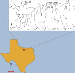
The study area is located in southwestern Wise County, TX. Residual soils in the area have developed primarily upon the Glen Rose Limestone, a lower cretaceous formation consisting of limestone, clay, and sand. The area lies within the Western Cross Timbers ecoregion, characterized by low hills with a regional gradient toward the southeast. Post oak and blackjack oak, with an understory of greenbriar, little bluestem, and purple top grasses, are common on sandy soils, whereas grassland prevails on slightly alkaline, clayey soils also present in this ecoregion (Griffith et al. 2004).
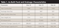
The study area was cleared of vegetation in most places and heavily used for cotton farming from the 1920s until the mid-1950s. Arsenic-bearing pesticides and defoliants were applied to the cotton fields. Ranches have occupied the study area since the 1950s. Three soil conservation ponds (sediment traps) were built in the 1960s to control displaced sediment (Table 1). These structures include an earthen dam, drawdown tube, and spillway (USDA 1997). When water reaches the drawdown tube, it flows downward through the pipe and laterally out the base of the dam. An emergency spillway accommodates excess water during floods. A guard keeps debris from entering the drawdown tube.
Materials and Methods
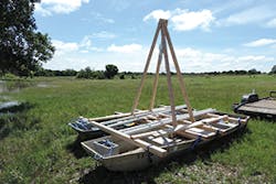
A portable wooden platform was built to retrieve cores from each soil conservation pond. The platform has 680 kilograms of lifting capacity and costs approximately $200 to build. It consists of a deck and derrick straddling two parallel johnboats approximately 0.25 meter apart. Each boat is approximately 3.5 meters long. The deck snaps into place between metal eyes screwed into wooden boards. Nylon straps pass through metal eyes on the frame’s exterior, under each boat, and up the other side to an anchor point. Corner straps cross diagonally for added stability.
The derrick is bolted to the frame and secured at the top with a crown bolt. This is the lifting point for a cable hoist. Beams spanning the length of the platform provide reinforcement and seating. Two or three people can install and operate the platform. Roped anchors at each corner of the structure immobilize it for coring. Operators lower the windward anchors, wait for them to tighten as the boats drift, and then drop the leeward anchors.
All three ponds were at conservation pool at the time of sampling–the water level was flush with the drawdown tube. Operators cored the sediment with 3-meter-long segments of 5-centimeter-diameter PVC pipe and threaded couplings. The leading edge of the first PVC segment was grinded sharp to reduce friction. Using only hand pressure, the pipe passed readily through pond sediment, but encountered stiff resistance upon reaching dense clay at the original base of the excavation. Operators struck an isolation plate at the top of the core with a sledgehammer, penetrating the dense clay to create a plug approximately 15 centimeters long. Upon reaching total depth, operators capped the top of the pipe and used a derrick and cable hoist to extract it from the pond.
At a local machine shop, cores were dried out and split lengthwise. A jig stabilized the core while a circular saw cut into it, using a backward rotation to avoid chipping. This initial cut left approximately 1-millimeter thickness of residual sidewall to avoid disturbing or contaminating the sample. Operators used a box knife to cut the remaining sidewall, followed by a fillet knife to split the core lengthwise into two halves.
Samples were taken from the exposed core and sent to a certified analytical lab for total arsenic analysis with EPA Method 6020A. Based upon core length, pond area, and age, analysts estimated volume of sediment deposited, percentage of storage utilized, and deposition rates.
Results and Discussion
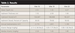
A large amount of sediment has accumulated in each pond, but especially at Site 13, which showed almost twice the sedimentation of Sites 12 and 22 (Table 2). These results reflect plowing and land-use practices in the headwaters of the sediment traps. Chisel and disk plowing has been practiced extensively in all three watersheds, thereby loosening the soil and making it highly vulnerable to erosion. However, the headwaters of Sites 12 and 22 were planted with switch grass and cover crops, whereas those of Site 13 remained barren during fallow periods. Prior studies have shown that vegetation is an effective way to reduce sedimentation. Where present, grass and other forms of vegetation bind soil and reduce sediment loading to ponds.
Arsenic concentrations in sediment cores were low, and typical of background levels (Scanlon et al. 2005).
While arsenic has a tendency to sorb to sediment, apparently it is not being transported with sediment in large quantities in the study area. Arsenic may preferentially attach to less-erosive iron oxide clays instead of silt or fine sand, as clay is less vulnerable to eroding and accumulating in the ponds. While arsenic levels are low, other agricultural chemicals likely accumulated in the ponds over the past 50 years and warrant further investigation. Ultimately, the sediment traps may be dredged and the accumulated sediment relocated.
Although the traps contain a large amount of sediment, they are effectively preventing it from moving downstream into major waterways and lakes used for drinking water, recreation, and plant and animal habitat. The traps effectively raise the base level of local streams, reducing energy and controlling gully erosion. Downstream, the dams reduce the amount of water flowing over the land surface. During wet periods, water spills through the dams, but vegetated and rock-lined discharge areas absorb hydraulic energy and slow erosion. High evaporation rates, approximately 180 centimeters per year, remove water from the ponds and reduce flow through the dams (USDC 1992).
In some cases, seepage through soil conservation ponds might also recharge groundwater; however, sandy bottoms would better facilitate this process. Moreover, siltation would likely slow recharge rates; frequent dredging would be necessary to maintain adequate infiltration and percolation rates to the water table. In the present study area, clay encountered at the base of ponds curtails aquifer recharge.
If the ponds are eventually dredged, this would likely take place during a dry period when water levels are relatively low. Dredged material could be placed into eroded terrain, compacted, and seeded.
In addition to controlling erosion, the ponds provide a source of water for cattle and support aquatic biota. Cattails, willows, reeds, cedar, oak, and hickory have grown in and around the ponds. The ponds also support turtles, frogs, fish, ducks, and birds such as egrets.
Conclusion
The objective of this study was to design a low-cost, transportable coring device for water reservoirs, and to test it on three soil conservation ponds in north-central Texas. The coring platform was inexpensive to build, easy to operate, and effective at retrieving cores. Cores showed that large volumes of sediment, ranging from approximately 37% to 80% of pond storage capacity, have accumulated over the past 50 years. Switch grass and cover crops appear to have reduced sedimentation in two of the three ponds. Eventually, the ponds may be dredged to restore storage capacity. Dredged material will not likely be contaminated with arsenic, but other chemicals may require some form of mitigation.
Acknowledgments
L. Penny, C. Gilley, and R. Simmons provided materials and helped design, build, and operate the coring platform. B. Gilley and J. Groce photographed the study. The Natural Resource Conservation Service and Wise County Soil and Water provided access to the ponds.
References
EPA. 2002. Arsenic in Drinking Water. US Environmental Protection Agency, Washington DC.
Griffith, G. E., S. A. Bryce, J. M. Omernik, J. A. Comstock, A. C. Rogers, B. Harrison, S. L. Hatch, and D. Benzanson. 2004. Ecoregions of Texas. US Geological Survey, Reston, VA.
Korte, N. E., and Q. Fernando. 1991. “A review of arsenic (III) in ground-water.” Critical Reviews in Environmental Control 21(1):1-39
Piltz, R. 1987. “Once the well is poisoned, it’s too late.” Grassroots: A Texas Department of Agriculture Publication, Fall issue, 1-11
Scanlon, B. R., J. P. Nicot, R. C. Reedy, J. A.Tachovsky, S. H. Nance, R. C. Smyth, K. Keese, R. E. Ashburn, and L. Christian. 2005. Evaluation of Arsenic Contamination in Texas. Bureau of Economic Geology, Austin, TX.
USDA. 1987. Soil Erosion by Water. US Department of Agriculture, Information Bulletin 513, Washington DC.
USDA. 1997. Ponds − Planning, Design, Construction. US Department of Agriculture, Washington DC.
USDC. 1992. Climatological Data Annual Summary, Texas. US Department of Commerce. National Oceanic and Atmospheric Administration, Washington DC.
Vahter, M. 2002. “Mechanisms of arsenic biotransformation.” Toxicology 181-182(27):211-217.
Welch, A. H., D. B. Westjohn, D.R. Helsel, and R.B. Wanty. 2000. ”Arsenic in ground water of the United States: Occurrence and geochemistry.” Ground Water 38(4):589-604.
