Renew & Restore
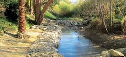
In recent years, Buck Gully Channel, located in the southern area of Newport Beach, Calif., has experienced multiple challenges, including instability and excessive dry-weather flows. These conditions have compounded storm water quality and natural resource degradation in the area while threatening adjacent properties and the quality of downstream Little Corona Beach.
Historically, Buck Gully was an ephemeral creek; however, beginning in the 1990s, adjacent hillsides were developed with residential uses and the Pelican Hill Golf Course. Irrigation associated with this development and increases in impervious surfaces resulted in increased frequency and volume of storm water flows to the creek. The creek now runs perennially, with flows equaling approximately 17 million gal per month during the dry season. These conditions resulted in significant erosion and degradation of the canyon, causing severe head cutting at portions of the channel at heights of up to 7 ft. This undermined channel stability and threatened the safety of the surrounding property. Additionally, the existing arch culvert at the adjacent Pacific Coast Highway (PCH) crossing had accumulated sediment over the years, resulting in the reduction of the downstream culvert opening to less than 2 ft.
The increased flows scoured out the canyon bottom, leading to a lower stream elevation and jeopardizing the canyon banks and existing residential development property. Other effects included deposits of large amounts of sediment in the canyon bottom, split stream flows, incised channels, flows shifting away from the center of the canyon and stagnation of open waters.
The change in the pattern and volume of the flows mirrored a change in the habitat of the creek, resulting in an increase of invasive and exotic plant species. Erosion at the canyon bottom led to disturbed morphology and habitat characteristics, such as water quality and species diversity. Additionally, native bird species anticipated to be present in Buck Gully were absent given the lack of native understory.
Challenges
Faced with these challenges, in a proactive project approach, the city of Newport Beach developed a team of civil and environmental engineers, surface water hydrology and water quality experts, natural resources experts, geologists, regulatory permitting experts and planners to study the channel and recommend solutions.
Buck Gully Channel runs through the study reach in a southwest direction, in a natural drainage system with a total tributary area of 1,070 acres at its ocean outlet, of which 637 acres are urbanized within the watershed. Hydrologic and hydraulic analysis of the Buck Gully watershed and channel within the study reach was needed, along with an evaluation of long-term stream stability. Development of alternative streambed and streambank stabilization for the channel was required, with consideration for maintaining it in a natural condition. Development of alternatives for water quality BMPs to use for removal of selenium in the channel before its outlet at Little Corona Beach and identification of restoration improvements also were needed.
Field investigations were conducted to document current conditions and stream restoration alternatives. Significant head cutting of the channel was noted approximately 500 ft upstream of Little Corona Beach, with excessive ongoing bank degradation on the meandering portion of the creek downstream of the PCH. In addition to these conditions, development of landscaped areas encroached into the channel bottom, and heavy growth of vegetation along the channel thalweg was promoted by increased dry weather flows.
Hydraulics
A hydraulic analysis of the canyon was performed using the U.S. Army Corps of Engineers HEC-RAS (River Analysis System) hydraulic model, and results were used to delineate water surface profiles for a range of storm events and 100-year floodplain boundaries. The results then were used to evaluate sediment transport and provide hydraulic parameters used in design and placement of bendway weirs at the meandering portion of the channel and gabion drop structures along the lower reach of the channel.
The Manning’s roughness coefficient used ranged from 0.03 and 0.04 for the main channel and rock drop structure sections, and 0.05 and 0.06 for the overbank areas. As part of the 100-year floodplain determination analysis, the channel’s Manning’s roughness coefficient was increased to 0.1 to produce floodplain limits based on a fully vegetated stream condition.
Channel Stability
A channel stability analysis was prepared based on the results of the hydrology and hydraulic calculations to assess the long-term trends of Buck Gully Channel through the study site. This analysis reviewed sediment continuity, equilibrium slopes, armoring potential, wash load, and vertical and horizontal channel response.
Lateral migration, bend scour, low flow incisement and local scour along the channel also were studied.
The sediment transport analysis identified recommendations, including the use of three gabion drop structures to obtain stable channel slopes based on the new watershed conditions. Rock-filled gabion mattresses were recommended for the drop structures in the channel. These environmentally preferred structures were installed with minimum construction impact using small equipment. The structures were backfilled with soil and vegetated to blend with the natural channel environment. Native willow cuttings also were installed at bankfull and around the gabions for additional bank support.
Five bendway weirs were proposed to help control the bank degradation in the meandering portion of the channel, approximately 600 ft downstream of the PCH. The weirs were used to help reduce the amount of bank protection requirements along the channel bends and promote natural banks.
Water Quality
The city of Newport Beach requested that a pilot water quality treatment and monitoring system be incorporated into the study and design. This “subsurface wetland” involved an underground filtration system that uses a series of sand and gravel filtration media to remove selenium.
A tank system holds the filtration system in place between the drop structures and is filled with the desired filtration media, to be placed interlocked in position and stacked in layers in the excavation under the channel and then covered with topsoil. Treated flows are discharged on the channel flow line at the most downstream drop structure.
Regulatory Compliance
Regulatory permits were required from the U.S. Army Corps of Engineers and Regional Water Quality Control Board, California State Fish & Wildlife, and California Coastal Commission. The project also required consensus building with the local community, as the majority of the project occurred on private land, requiring outreach to more than 35 property owners. In addition to tackling erosion and vegetation issues, the city’s team designed subsurface flow wetlands, which further treat runoff from upstream pollution sources prior to discharge at Little Corona Beach.
The successful rehabilitation of Buck Gully was a proactive initiative by the city of Newport Beach to protect the health of the canyon and existing development. The project now is under a five-year monitoring program that includes functional rapid assessment, qualitative and quantitative monitoring, and preparation of annual reports. The reports and GIS mapping, prepared by restoration ecologists and wetland scientists, will be submitted to the regulatory agencies over the next several years. The reports will identify the functions and values of the site as well as adaptive management measures to increase site success.
Success So Far
Early water quality monitoring results show an 80% decrease in fecal coliform and other lower constituent levels once water filters through the project site. The California Coastal Commission staff has called this “a model restoration project” as the year one monitoring results found significant native vegetation cover and more diverse species, well beyond permit requirements. The stability of the channel has allowed for a variety of species to take hold, ranging from early grass species for erosion control to understory/streamside species and tree species like willow, sycamore and cottonwood. The project will continue formal biological monitoring in the spring and summer of 2014.
Download: Here


