Designing with nature for coastal risk reduction in Connecticut
When it comes to coastal risk reduction, however, New Haven and Fenwick share the problems of shoreline erosion and loss of coastal marsh habitat from the impacts of more frequent and more severe coastal storms due to climate change. Both have taken the road less traveled to address the threat of rising sea levels and storm surges. Rather than breakwaters, sea walls and bulkheads, they applied a design with a natural approach: maximizing, where feasible, the use of nature-based solutions. Both communities are installing living shorelines, designed to be resilient to waves and storm surges and to reduce shoreline erosion of bluffs, beaches and dunes while creating marsh vegetation that also mitigates the impacts of coastal flooding. These natural and softer shorelines can also be combined with other flood mitigation infrastructure to keep these coastal areas protected from erosion, increasing the sustainability of the shoreline landscape, and appear welcoming to visitors.
Alongside teams of partners, members of GZA’s Design With Nature Studio have been closely involved for years with state and municipal leaders in New Haven and Fenwick.
New Haven
The Long Wharf area of New Haven, located within FEMA VE and AE high risk flood hazard zones, is highly vulnerable to coastal flooding. It has historically experienced severe flooding and flood damage from hurricanes and extreme weather events, dating back to the Hurricane of 1938 and more recently Hurricane Irene and Superstorm Sandy in 2011 and 2012. As Long Wharf is home to critical highway and rail infrastructure, as well as an industrial district that supports more than 5,000 jobs, improved resilience to coastal flooding is imperative for the social, economic and ecological resilience of the city of New Haven and the region.
The Long Wharf Flood Protection Study, which GZA developed with a team that included Utile, Biohabitats, and Cambridge Systematics, produced a detailed flood vulnerability analysis and planning and design of coastal flooding mitigation and shoreline protection measures for the area located northwest of the Long Wharf shoreline to Union Avenue. The team identified flood mitigation strategies that not only address economic concerns related to business disruption after flooding but also identified ways in which the flood mitigation alternatives can benefit the public by creating a visionary plan with the City Plan Department to improve social, economic, and ecological resilience to sea level rise, local intense precipitation, storm surge, and erosion.
The team’s work in New Haven is an example of how planning for coastal risk reduction can go beyond just defensive and protective measures to become an opportunity to re-envision and expand public access to coastal areas and make them more welcoming, functional and habitable to people, animals and plant life.
In conjunction with the study, the team has also developed permit-level design for the proposed Long Wharf Flood and Shoreline Protection project that enables the city of New Haven to move forward quickly with final design and construction as funding was secured.
As recently presented by City Engineer Giovanni Zinn, P.E., at the Connecticut Institute for Resilience & Climate Adaptation (CIRCA) “Super Storm Sandy in Connecticut: Progress & Challenges After Ten Years” event, the city’s forward-looking and comprehensive resilience efforts include major improvements to area stormwater management; planning, design and funding of the Long Wharf flood protection levee (also known as the New Haven County Coastal Storm Risk Management Project); and natural resource habitat enhancement and shoreline protection with the Long Wharf and East Shore Park “Living Shoreline” projects. The final design and permitting for these projects are planned to be completed by 2025 and construction is expected to be completed by 2028.
The many years of comprehensive planning have positioned New Haven well to compete for available federal funding. In 2022, more than $185 million of federal disaster relief funds and Federal Emergency Management Agency Building Resilient Infrastructure and Communities (BRIC) grant funding has been secured for these coastal resilience projects. In addition, $63 million in federal economic development funding from the Bipartisan Infrastructure Law was received for completing the New Haven Harbor Navigation Improvement Project.
Fenwick
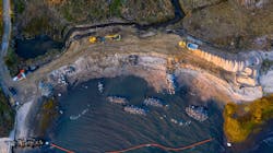
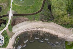
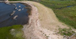
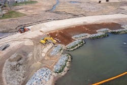
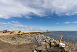
Up the Long Island Sound coast in Fenwick, the 450-foot-long strip of beach and dune known as the Hepburn Dune experienced decades of significant erosion from coastal wave action. The Hepburn Dune, where the Connecticut River enters the sound, derives its name from its proximity to the family estate of the legendary film actress Katharine Hepburn. The community faced the threat that a breach of the barrier spit could damage both property in the river’s estuarine area and the recently restored Lynde Point Marsh and Crab Creek located upland of the spit. The Borough of Fenwick and Lynde Point Land Trust had expended significant effort and cost to stabilize the shoreline and Lynde Point Marsh during the prior 15 years. Crab Creek, located landward of the dune, was for a time blocked by sediment, requiring the Connecticut Department of Energy and Environmental Protection (DEEP) to make emergency repairs.Beginning in 2017, GZA GeoEnvironmental worked with the Borough and the Land Trust to develop a living shoreline solution to mitigate erosion that includes a nearshore wetland sill to attenuate prevailing wave heights, new fill and tidal wetlands between the sill and the beach, reshaping of cobble beach, and dune restoration with a quarry stone-reinforced, planted dune above the Coastal Jurisdiction Line. The project also entailed realigning Crab Creek and replacing a culvert to enable proper tidal flushing of a pond and improving the habitat value of this pond. The project was constructed and completed in June 2021.
A critical element of the plan involved high resolution, two-dimensional numerical wave model (SWAN) to characterize nearshore waves. The results of the wave modeling were used to determine the need for wave attenuation (for new marsh survivability) and inform placement of the living shoreline features (e.g., wetlands and rock sills) to conform to the existing shoreline geomorphology and tidal and wave currents. This design approach enhances shoreline stabilization while avoiding significant habitat impacts and preventing additional shoreline erosion.
“Living shorelines are an innovative solution to restoring damaged coasts and providing a green way to adapt to a changed climate,” said Ron Rhodes, Connecticut River Conservancy’s interim director. “We are incredibly grateful for the generous support and wonderful project partners that helped restore this coastline and protect it into the future.”
In 2022, the Connecticut Green Building Council honored the Hepburn Dune project with its Resilience Award of Honor for work by GZA, the Borough of Fenwick, Lynde Point Land Trust, SumCo Eco-Contracting, LLC, CIRCA, and the Connecticut River Conservancy.
Conclusion
For more than a century, most approaches to U.S. coastal risk reduction have involved “gray” solutions like seawalls, jetties and rip-rap reinforcement of bluffs. Today, it is widely recognized that as we become more experienced with nature-based solutions, we can implement less intrusive natural and green infrastructure solutions like living shorelines, beach reinforcement, submerged breakwaters that function as reefs for marine life and these design with nature approaches can be more adaptive and sustainable over time.
In most cases, however, it is unlikely that an all-gray or all-green solution will be the most successful approach. New Haven and Fenwick, two different communities that share frontage on Long Island Sound, offer examples of the complexities and the upside opportunities for co-benefits associated with maximizing nature-based approaches to making our coasts more resilient, protected and welcoming to all.
About the Author
Wayne Cobleigh
Wayne Cobleigh is vice president of client services for GZA GeoEnvironmental Inc..
