Kline Levee Reconstruction at Lake Maxinkuckee

A Brief History
Lake Maxinkuckee is a 1,864-acre kettle lake located in north-central Indiana. Kettle lakes are depressions in the earth’s crust, left behind approximately 15,000 years ago by the receding glaciers, after partially buried ice blocks melted and the depressions filled with water. The lake is 2.6 miles long and 1.6 miles wide with a maximum depth of 88 feet and an average depth of 24 feet.
From native Americans to famous Hoosiers like composer Cole Porter and literary giants Kurt Vonnegut Jr., Lew Wallace, Booth Tarkington, and James Whitcomb Riley, people have been drawn to the beautiful shores of Lake Maxinkuckee. The East Shore of the lake is designated a national historic district dating to 1873 and includes examples of Late Victorian, Colonial Revival, and Bungalow/American Craftsman style architecture.

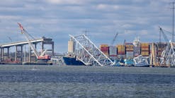
As a result, over the next decade, three wetlands were constructed to buffer the lake from the surrounding watersheds. Unfortunately, the levee at the Kline wetland, well past its projected lifespan, failed multiple times in recent years and required costly repairs. A 2018 design study concluded that repair was no longer an option and a major reconstruction of the levee was needed, at a cost of approximately $400,000. Even though this wetland is situated on the Indiana Department of Natural Resources (DNR) property, LMEF felt strongly they could not wait for the state to make this a priority project and decided to take the lead. (Figure 3).
Successful Fundraising
A state grant from the DNR’s Lake and River Enhancement Program (LARE) was secured in the amount of $100,000. The Town of Culver, Culver Redevelopment Commission, Culver Academies (a private boarding school for high school students), Union Township, Marshall County Community Foundation, and Marshall County Soil and Water, all of whom have a stake in preserving the lake’s water quality, contributed to the project as well. Combined with the LARE grant, 50% of the project was funded.
Like many inland lakes in the region, Lake Maxinkuckee is surrounded by single-family homes, both for year-round residents and secondary vacation homes. The town of Culver, which sits on the north shore of the lake, has a population of under 1,500 and many of the houses in town are also used as secondary vacation homes. With no large industry in the area to tap for corporate sponsorships, LMEF began a letter-writing campaign to private citizens. Within a few months, an additional $200,000 was raised, enough to fully fund the project.

The purpose of the reconstruction project was to prevent sediment transport from the marshy Kline Wetland into Lake Maxinkuckee during storm events and periods of high water. The project would raise the levee by approximately one to four feet to accommodate 100-year flood events and provide a barrier between occasional raises in water levels into the adjacent lake. The total levee height would be between 4 and 5 feet above surrounding grades. Water levels in the wetland would be controlled by a stop log-style sluice gate structure.
S&L Environmental Group out of Goshen, IN, was hired to begin construction in early October 2019, with completion scheduled for December the same year. However, at the end of November, LMEF was notified that fill soil being deposited was settling along a 250-foot section, unlike the rest of the levee (Figure 1). Additional soil was added, which just continued to settle.
Construction was halted in order to conduct Cone Penetration Testing (CPT) and Standard Proctor Testing (STP). Testing was done in the un-failed zone where the levee was successfully constructed and the remaining SPT and CPT tests were performed in known failed or presumed very soft soil conditions. The rationale for performing tests in the different soil conditions was to be able to provide a reference point and to compare the soil properties of the supportive subgrade to the unsupportive subgrade. Unfortunately, bearing capacity could not be obtained at borings in the failed zone due to very soft conditions, high organic content, high moisture content, and high consolidation properties.
Meanwhile, in an attempt to continue construction on the north side of the failed zone, a temporary bridge (Figure 2) was constructed spanning the problem area. However, due to mild winter temperatures, the ground did not freeze, and construction equipment could not navigate the muddy conditions (Figure 4). All construction was halted until levee conditions improved. Before construction could begin again, a statewide shutdown was mandated due to COVID. Construction did not begin again until May 2020.
In the meantime, analysis of the CPT and STP tests continued and yielded three alternative solutions for addressing the failed zone:
Constructing the levee system with conventional fill materials and geotextile reinforcements. Upon completion to final grade, the levee system would be monitored for subsidence/settlement and maintained, as needed, by filling and grading to restore the levee top elevations on a periodic basis, as needed.
Constructing the levee system with a combination of conventional fill, lightweight geofoam blocks, and geotextile reinforcements. The levee system would then be monitored for subsidence/settlement and maintained, as needed, by grading to restore levee elevations on a periodic basis, as needed.
Install rigid ground improvement elements consisting of Controlled Modulus Columns, or similar, topped with a granular load transfer platform supporting the overlying constructed levee system.

A Solution for the Failed Zone
A low strength subgrade section was constructed with a base layer of AASHTO No. 3 stone reinforced with two layers of non woven geotextile (Stabilenka 300/45, Tenesar TX130, Miragrid 2XT, or similar). The stone fill was also completely wrapped in a woven geotextile filter fabric (Mirafi 140NC, or similar). For the bottom layer, a combination reinforcing grid and filter fabric material (a Tensar FilterGrid FG30, or similar).
The construction sequence was as follows:
Step 1:
a) Place filter fabric at current subgrade
b) Place a layer of geogrid
c) Place 8 to 10 inches of compacted AASHTO No. 3 stone
Note: steps a) through c) extend 5 feet laterally beyond the toe, off both sides of the levee
Step 2:
a) Place the second layer of geogrid at top of Step 1 stone fill
b) Place the second layer of compacted 8 to 10 inches No. 3 stone
Note: Steps a) and b) extend 5 feet laterally beyond the toe, off both sides of the levee
Step 3:
a) Fine grade stone to the general shape of the levee with consider- ation for required planting material for vegetative growth
b) Place filter fabric over the top of the extent of the stone placement
c) Place levee common fill on top of filter fabric to planned elevations
Step 4: Based on continued measurements and monitoring, additional levee common fill material to maintain grade requirements will be needed.
Final Cost
The cost of the temporary bridge, soil borings, Cone Penetration Testing (CPT) and Standard Proctor Testing (STP), the geotechnical solution for the failed zone, and additional labor and materials added approximately $182,000 to the original bid for construction. Additional funds will be needed for Step 4 to restore levee elevations on a periodic basis.

LMEF did not take on this project lightly. Even though we thought we had done our due diligence and pre-construction surveys were conducted, access to the levee was limited. The unexpected soil settling was a huge blow. In the words of author T.F. Hodge, “To conquer frustration, one must remain intensely focused on the outcome, not the obstacles.” This project certainly presented obstacles, from the unforeseen soil settling to warm winter conditions and eventually to COVID restrictions.
LMEF never lost sight of the big picture and fulfilling our mission—working toward the preservation of an ecologically-sound Lake Maxinkuckee and its surrounding watershed. By leveraging relationships with state and local government, along with private resources, LMEF was ultimately able to complete this construction project that will protect Lake Maxinkuckee for generations to come.
Debbie Palmer is the president of LMEF. Palmer is project manager for restoration and research projects, and responsible for outreach presentations, monitoring the lake and its wetlands, and community resources for all things related to the well-being of Lake Maxinkuckee and its surrounding watershed. Palmer has a BS from Purdue University, Indiana Watershed Leadership Academy, and is an Indiana Clean Lakes Program-Hoosier River Watch-Marshall County Lakes and Waters volunteer and an Indiana Lakes Management Society Board Member.
Debbie Palmer
Debbie Palmer is the president of LMEF. Palmer is project manager for restoration and research projects, and responsible for outreach presentations, monitoring the lake and its wetlands, and community resources for all things related to the well-being of Lake Maxinkuckee and its surrounding watershed. Palmer has a BS from Purdue University, Indiana Watershed Leadership Academy, is an Indiana Clean Lakes Program-Hoosier River Watch-Marshall County Lakes and Waters volunteer, and an Indiana Lakes Management Society Board Member.