Whether for purposes of navigation, irrigation, improved drainage, flood control, power generation, or simply to control a vital resource, rivers and streams of all sizes have been modified in ways great and small for millennia. Channels might be widened or narrowed, dredged or filled in, straightened or moved entirely, but ultimately the issue is whether the resultant “fixed” stream accomplishes what is intended or not, and whether it is stable or not.
Pioneering hydrologist and geomorphologist Dr. David Rosgen notes the cumulative effects of river management and mismanagement. “The effects of road construction, riparian vegetation change, in-channel gravel mining, logging, reservoirs/diversions, urban sprawl, and other similar developments have significantly changed flow and sediment regimes and the boundary conditions associated with stable stream systems,” he states. “Direct disturbance to channels by straightening, lining, draining, raising, lowering, clearing, dredging in the name of flood control, navigation, and other single-purpose objectives have taken a serious toll on the physical and biological functions of our rivers.”
Environmental issues have become increasingly urgent. “Public awareness over the last decade has prompted federal, state, local jurisdictions, and environmental groups to direct major efforts at preserving, protecting, enhancing, stabilizing, rehabilitating, and restoring rivers throughout the United States,” says Rosgen. “Society has spent the last 200 years changing landscapes; now, they want their rivers back.”
However, Rosgen says, despite the best of intentions, sometimes restoration projects go awry. “Many such failures,” he writes, “are a direct result of the lack of a clear understanding of the cause and consequence of instability. The difference between success and failure in river restoration is often associated with the effort expended in watershed/river assessment.”
Early River Restoration Approaches
Professor Richard Hey noted in the April 2006 issue of the Journal of the American Water Resources Association scientific approaches to river restoration dating back to the late 19th century. What are termed regime equations were developed to define how elements such as flow, sediment transport, bed and bank material, bank vegetation, and the valley slope affect the profile and pattern of a river. “The earliest equations,” he writes, “concentrated exclusively on the effect of discharge on channel form and are often referred to as hydraulic geometry relations.”
Then there are what he terms rational equations. Hey explains, “Rational equations offer a theoretically based alternative to empirical regime equations for designing alluvial channels. If equations could be specified for each process that controls flow, sediment transport, and channel adjustment in alluvial channels, their simultaneous solution would enable the morphology of natural rivers to be prescribed given the boundary conditions.”
The reality, however, is that both the regime and the rational equations have significant limitations. Hey notes, “As most of them are restricted to the design of straight channels in a particular river environment, it raises questions about their general utility for natural channel design. For many types of rivers, there are no relevant equations. Even if the equations are appropriate, there will still be some uncertainty in the predicted channel dimensions.”
In 1994, Rosgen published his landmark “A Classification of Natural Rivers” in the journal Catena. This was the culmination of some 25 years of work in which he developed an extensive fluvial geomorphologic database composed of actual field measurements of literally hundreds of streams throughout the US, Canada, and New Zealand.
In this article, Rosgen described a progression of stream classification systems that had been previously proposed. An 1899 effort was as simple as a division into three stages: “youthful, mature, and old age.” In 1957, straight, meandering, and braided patterns were described, as well as quantitative slope-discharge relationships for these patterns. In 1963, elements of channel stability and sediment transport were added. Later that decade, additional classification systems were developed that took into account depositional features, vegetation, sinuosity, meander scrolls, bank heights, levee formations, and valley types. More recent systems developed in the 1980s and 1990s added elements of the form and gradient of alluvial channels, as well as characteristics of bank and sediment materials.
Rosgen noted that “with certain limitations, most of these classification and/or inventory systems met the objectives of their design,” but added, “Typically, theoretically derived schemes often do not match observations.”
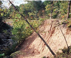
First Hollow Run stream prior to restoration
Explaining the genesis for his somewhat controversial-but now generally accepted-method of stream classification, Rosgen says, “The requirement for more detailed, reproducible, quantitative applications at various levels of inventory over wide hydrophysiographic provinces has led to further development of classification schemes.”
The Rosgen System
Thus was born a new system of stream classification that bears the name of its creator. The “Rosgen Method” broadly involves four levels of assessment:
I. Broad morphological characterization (i.e., river profile morphology, general river pattern, basin relief, and valley morphology)
II. Description of stream type (involving channel patterns, entrenchment ratio, width/depth ratio, sinuosity, channel material, and slope)
III. Stream condition (which includes, among other elements, riparian vegetation, depositional patterns, fish habitat, flow regime, channel stability, and bank erodibility)
IV. Field verification (requires direct measurements and observations of sediment transport, bank erosion rates, aggradation/degradation, hydraulic geometry, fish biomass, and riparian vegetation)
Level I relies heavily on aerial photography and/or topographic maps to differentiate valley types into one of 11 forms and to classify a stream as one of eight broad types.
Level II, utilizing field measurements, involves much more specific stream differentiation, categorizing a stream into one of 94 variations. Once a stream has been accurately classified, educated projections may be made regarding its sensitivity to disturbance, the streambank erosion potential, the level of influence of riparian vegetation, and the stream’s likely recovery potential.
Level III analyzes the spatial and temporal variations in both the stream and its watershed to determine the causes and extent of its instability. For this stage, Rosgen describes what he refers to as a departure analysis, comparing the stream being analyzed to a stable reference channel.
Level IV is used to provide information on channel processes within specific stream reaches. It is also used to evaluate prediction methodologies and the effectiveness of repair and restoration efforts by stream type.
One might ask how all of the detailed information obtained from such stream assessment is used. Rosgen wrote in an article titled “Restoration WARSSS”:
“Changes to the morphological, sedimentological, hydraulic, and biological character of river channels must be compared to a stable reference stream
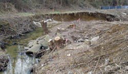
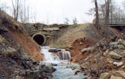
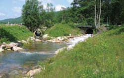
Before stream restoration was completed at Biddison Run in Baltimore, MD
representing the same valley type. Thus, the nature, extent and consequence of departure must be understood to relate observed characteristics to “˜potential’ states. If this information was not collected and analyzed, then how would a river restoration designer know how wide, deep, straight, crooked, steep, etc. to make the stream? What should be the stable dimension, pattern, and profile? Can the restored stream move the largest sediment size, can it move the sediment load? These are not simple questions, nor are there simple solutions. However, methods are available to make these assessments and calculations in order to reduce some of this uncertainty in river restoration.”
In fact, the four assessment levels above are part of Rosgen’s larger eight-phase comprehensive restoration process, which describe the entire stream repair/restore project from beginning to end. These sequential phases are defined in the “Rosgen Geomorphic Channel Design” chapter of the NRCS Stream Restoration Handbook:
- Define specific restoration objectives associated with physical, biological, and/or chemical processes.
- Develop regional and localized specific information on geomorphologic characterization, hydrology, and hydraulics.
- Conduct a watershed/river assessment to determine river potential, current state, and the nature, magnitude, direction, duration, and consequences of change. Review land use history and time trends of river change. Isolate the primary causes of instability and/or loss of physical and biological function. Collect and analyze field data including reference reach data to define sedimentological, hydraulic, and morphological parameters. Obtain concurrent biological data (limiting factor analysis) on a parallel track with the physical data.
- Initially consider passive restoration recommendations based on land use change in lieu of mechanical restoration. If passive methods are reasonable to meet objectives, skip to the monitoring phase (phase 8). If passive efforts and/or recovery potential do not meet stated multiple objectives, proceed with the following phases.
- Initiate natural channel design with subsequent analytical testing of hydraulic and sediment transport relations (competence and capacity).
- Select and design stabilization/enhancement/vegetative establishment measures and materials to maintain dimension, pattern, and profile to meet stated objectives.
- Implement the proposed design and stabilization measures involving layout, water quality control, and construction staging.
- Design a plan for effectiveness, validation, and implementation monitoring to ensure stated objectives are met, prediction methods are appropriate, and the construction is implemented as designed. Design and implement a maintenance plan.
Not Everyone Agrees
There are those who take exception to Rosgen’s methodologies. Some of the criticism includes:
- Rosgen’s Level I and Level II analyses cannot be used to predict river behavior and are unreliable for determining correct mitigation processes.
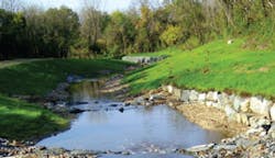
After Baltimore’s Biddison Run stream was restored
Rosgen’s response: The Level I and Level II data are not intended to predict river behavior or to recommend specific restoration approaches in and of themselves. The Level III and Level IV stages must also be completed before any such assessments may be made.
- Stream restoration should avoid using form-based methods and instead use process-based approaches.
Rosgen’s response: Form and process are not mutually exclusive; they are critically linked. River morphology (form) reflects boundary conditions and flow processes. Variation in either boundary condition or flow process will alter channel morphology. - Using the Rosgen classification, channels have to be fit into some category, whether it is appropriate or not.
Rosgen’s response: The stream classification system was developed from morphological measurements of hundreds of rivers, indicating a trend of variables and their ranges that were then grouped into discreet channel types; they were not “force-fed” into arbitrary units. A dual stream type is designated when selected delineative variables overlap between types rather than “forcing” a classification category.
Rosgen can be quite blunt in his assessment of his critics. “The people who are most adamantly opposed [to his stream classification system],” he says, “are those who are the least familiar with it and who aren’t in the business of river restoration. They don’t offer alternatives.”
He is particularly irked by those who claim that his system is all about morphology (form), while ignoring process (i.e., sediment transport, changes in flow, and erosion). “Form is created from process,” he maintains. “Form and process are directly integrated.” Indeed, many of his published papers are clear on this point.
Regarding restoration efforts, he is insistent on taking a comprehensive approach in which “analytical, morphological, and empirical relationships are
Before restoration was completed at the First Hollow Run stream
carefully analyzed in order to determine a restoration approach.” His goal is to understand a stream’s natural flow and to match mathematically the stable form of the stream to channel reaches being repaired or restored.
Far from sitting in an ivory tower of academic research, he stresses that he is “putting principles into practice” gained from more than 40 years of working in the field. After his 20 years with the US Forest Service, he says, “I wanted to come up with an alternative” to the frequent use of riprap, concrete, and other artificial methods of restoration. He much prefers using native material.
In his book, Applied River Morphology, Rosgen explains the ultimate goal of performing such careful and exacting assessments:
“Natural stream channel stability is achieved by allowing the river to develop a stable dimension, pattern, and profile such that, over time, channel features are maintained and the stream system neither aggrades nor degrades. For a stream to be stable, it must be able to consistently transport its sediment load, both in size and in type, associated with local deposition and scour. Channel instability occurs when the scouring process leads to degradation, or excessive sediment deposition results in aggradation. When the stream laterally migrates, but maintains its bankfull width and width/depth ratio, stability is achieved even though the river is considered to be an active and dynamic system.
“The consistency of dimension, pattern, and profile that exists among rivers is more than chance or spurious correlation. Mathematical relations exist illustrating a stratification of river systems by unique morphological forms that provide meaning in an otherwise random appearing, complex set of interrelated variables. Whenever proper attention to the “˜rules of the river’ is not respected, adverse channel adjustments often result in damage to personal property and loss of life.”
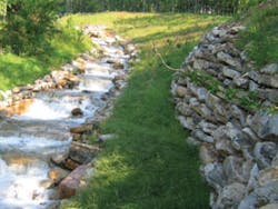
After restoration was completed at the First Hollow Run stream
First Hollow Run
“When I was a kid, I used to jump over this stream,” the old-timers told Tracy Litwiler, project manager for Meadville Land Service in Pennsylvania. But First Hollow Run, a tributary of the Lehigh River in picturesque Carbon County, PA, had grown to as much as 100 feet wide and up to 30 or 40 feet deep in spots. Litwiler explains that the stream is located in a historical mining area. The stream that had once been narrow and shallow had suffered severe scour.
In 2001, Pennsylvania Growing Greener grants were issued to begin the repair process and the Harrisburg, PA, engineering firm Skelly & Loy was hired. The company’s vice president of environmental engineering, Gerald Longenecker, describes what he found.
“First Hollow Run is located in a very steep area, with an approximate 11% slope, and the coal mining resulted in this stream being diverted around a mine spoil, together with the neighboring stream, Second Hollow Run. The contents of the mine spoil were nothing like compacted soil, so water started chewing away at the edges of the mine spoil, which was composed of easily eroded material.”
Because the channel was very steep, and because Second Hollow Run had effectively merged with First Hollow Run, there was a massive amount of energy in the water flow. As a result, the combined stream rapidly eroded a deep, V-shaped ravine to the point that a formerly buried water pipe at the stream’s edge had been exposed with the local water authorities fearful of a pipe failure.
“This stream should have been 20 feet wide and two or three feet deep,” says Longenecker, “but the banks and sidewalls were being washed into the stream corridor, and both sides of the channel were being eroded to the point that even areas well away from the mine spoil were being damaged.”
In describing his initial stream assessment approach, Longenecker explains, “The concepts of fluvial geomorphology that Rosgen preaches were heavily used in establishing cross-sectional dimensions of the main channel [“˜bankfull channel’ in his terminology] and also minimum flood plain width to locate the base of the rock wall [at the edge of the stream]. Other techniques were blended with his methods to design the boulder step structures” that were used in reducing flow velocity.
In the vicinity of the old mining operations were fields of massive boulders, 10 feet or more in width, that were essentially waste material, as Longenecker recalls. “But this negative became a positive in the restoration process,” he says. “This was exactly what we needed-huge boulders or mass to resist the intense energy of the water. And this was used as the first defense to restore stability to the stream. The landowner gave us permission to use these boulders and this saved hundreds of thousands of dollars on the project. They were all within about a mile of the site.” More than 3,000 tons of boulder rock was used. Engineers at Skelly & Loy later presented a technical paper describing their creation of such a step-pool stream channel (Rosgen A-type stream) using large “keystone” boulders to produce a natural-looking channel.
Project manager Litwiler points out another negative-turned-positive. There were a large number of trees located on the upper banks of the stream, but the eroding soil could no longer support the root structure. Trees were being uprooted and falling into the river.
With trees that had already toppled, or that were in danger of doing so, Litwiler made use of the large mass of material. “We separated the root mass and the first 10 to 15 feet of log from the rest of the tree and turned it into a root wad revetment. This root wad was placed in the water and oriented so as to oppose the stream flow. The root wad was anchored into the slope with rocks and more logs, and the result was that this manipulated the base course flow of the stream. It also created a habitat for fish. It’s much less costly when onsite materials are available to be used in this manner.”
Furthermore, he says, crews then cut the rest of the tree into pieces and used the pieces as “bunny huts” to provide shelter to small animals in the area. As a result, every portion of these failed or failing trees was used to improve the environment in and around the stream.
Longenecker recalls a surprising turn of events at the site. “A spoil pile on one side of the channel was actually higher than the tops of the houses on the other side of the channel.” The plan was to substantially grade back this spoil, but it turned out that the homeowners in the area actually preferred that the massive spoil remain in place, because it provided a nice windbreak for them.
“Instead,” says Longenecker, “we planted many trees and brush to build a natural fence or filter that runs parallel to the stream about 20 to 40 feet away from the water’s edge, on the same side as the spoil mound. This acts to catch material coming down the spoil bank. So although there is still a very steep bank where the mine spoil is located, we have managed to arrest erosion at the base of the slope and the area is slowly stabilizing.”
Another part of the restoration effort was to create a series of mini-waterfalls cascading into a deep pool area that was created by another large boulder about 20 feet down the stream channel. Each step along this cascading waterfall dissipated some of the energy of the water, decreasing turbulence. Not only did this help to stem the erosion, but a couple of the homeowners even built small observation areas where they could sit and enjoy the sound of the rushing water, Longenecker says.
There were indeed many challenges encountered and unique solutions instituted. By the time the restoration was complete in 2006, 1,300 linear feet of First Hollow Run had been reconstructed, reducing its width to 19 feet, with a depth of some 2.5 feet. The project was such a success that engineering firm Skelly & Loy was awarded a Diamond Award Certificate for Engineering Excellence by the American Council of Engineering Companies of Pennsylvania.
Three Forks Ranch Stream Restoration
Straddling the Colorado-Wyoming border, the massive Three Forks Ranch lies along the Little Snake River. It is claimed that the restoration work undertaken on this portion of the Little Snake River represents the largest privately funded river restoration project in US history.
Ranch general manager Jay Linderman wrote about the huge effort in the fall 2001 newsletter of the Colorado Riparian Association. He explains, “The river bottom, being fertile, easily accessible and irrigable, was overused and abused for many years. Overgrazing and haying resulted in the destruction of the willow community along the riverbanks. Bank degradation soon followed and a near-irreversible cycle began. Over time, the river channel became wide and shallow. Stream banks became abrupt drops of 3 to 6 feet into the river. Each spring, snowmelt runoff added to the problem. Water temperatures increased and dissolved oxygen levels declined. These two factors, along with increased sedimentation, greatly reduced the fish habitat in the river.”
The ranch brought in Dave Rosgen to assess the situation and to implement the river reconstruction. “The restoration goals,” Linderman wrote, “were to restore natural stream bank stability, establish woody riparian vegetation, greatly reduce bank erosion, create wetlands, and improve fish habitat. This required deepening and narrowing the river channel, which would lead to cooler water temperatures and increased dissolved oxygen levels. The steep, eroded banks were removed and native cobble was used as a revetment in an effort to eliminate future erosion.”
In addition, “Approximately 22,000 large boulders were placed along about four miles of river in the form of Rosgen-designed structures [e.g., J-hooks, W-wiers, and cross-vanes] to divert the stream’s energy away from the banks and toward the center of the stream. The rock structures also created pool for fish. In reaches of the river that had been straightened in the past to facilitate irrigation or road building, the natural sinuosity of the channel was restored. When the massive reconstruction was completed, mature willows and sod were transplanted on the outside of every meander bend to further stabilize the banks and to create shade to reduce water temperature.”
The unprecedented restoration effort was such that downstream neighbors of the ranch requested that their portions of the river also be reconstructed to improve function and stability. To date, some 16 miles of the Little Snake River have now been restored to what it may have looked like a century or two ago.