A greater emphasis on maintaining a more natural environment is underscoring a number of contemporary streambank repair and dredging operations.
In some cases, the solution comes at a higher cost.
But agencies making the investment are considering a greater long-term return on the investment.
For many years, Santee, CA, had wanted to develop an area along Forester Creek, which flows northwest through a concrete-lined channel in El Cajon into Santee, located 17 miles northeast of San Diego.
The creek meanders along commercial and residential areas before flowing into the San Diego River northwest of town. That river travels south and west and eventually drains to the Pacific Ocean.
But Forester Creek had its problems. Among them, the Federal Emergency Management Agency (FEMA) had identified the area as a Special Flood Hazard Area with a 10-year flood level, requiring costly flood insurance-an unattractive consideration in development.
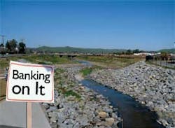
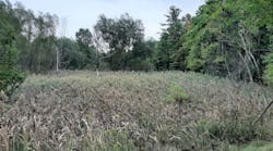
Forester Creek in Santee, CA, after a full revegetation
In January and February 1995, 6 inches to 3 feet of water created flooding conditions that necessitated the evacuation of 20 homes and rerouting of traffic from flooded roads.
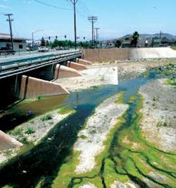
Additionally, there had been water-quality problems, including low levels of dissolved oxygen and high levels of phosphorous and fecal coliform from sewage, homeless encampments, and wildlife.
To address the situation, Santee entered into a $36 million capital improvement project, the Forester Creek Improvement Project. The capital improvement project entailed widening and realigning Forester Creek to withstand a 100-year flood and restoring riparian and wetlands habitat.
The focus of the project-which began in January 2006 and ended in late 2007-was a 1.2-mile-long segment of Forester Creek. Its completion-which created a flood containment of a 100-year level-cleared the way for the California Department of Transportation (Caltrans) to finish the final segment of State Route 52 to intersect with State Route 67 and link Santee with La Jolla.
The project involved excavating and relocating five separate sewer systems, water lines, and several dry
The Forester Creek channel was widened and bridges were lengthened
utilities in sequence, as well as bridge demolition and construction. The finishing touches were a landscape design of native plants and trees such as coastal sage scrub and southern willow scrub, the construction of pedestrian and bike paths, and a linear park featuring picnic tables.
The solution was a long time coming. In the mid-1970s, officials from the County of San Diego had considered addressing the problem by building a concrete channel. At the time, the approach was considered the best in terms of easy repairs, shorter bridge spans, and better flood control.
A concrete channel and additional development upstream of Santee in El Cajon laid the groundwork for increased flooding. Accelerated water flows associated with concrete, when it replaces natural wetland and riparian areas, resulted in a more rapid transmission of trash, polluting Forester Creek and areas downstream at its discharge into the San Diego River.
Other approaches had been considered, including a concrete-lined option, an unlined option, and two options involving wetlands restoration and excavation of the channel banks.
Santee initially sought to line the lower one-third of the creek channel with concrete and vegetate the remaining two-thirds in an effort to fully mitigate wetland impacts and minimize traffic disruptions.
The San Diego Regional Water Quality Control Board joined environmental groups in promoting an unlined solution-a complete revegetation through the entire length of the widened section-which was considered gentler on the natural surroundings.
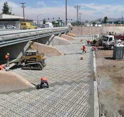
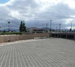
Articulated concrete blocks reinforce the channel bottom.
Such an approach cost $10 million extra, but Santee and the Federal Highway Administration in 2003 proceeded to eliminate the concrete option and widen and revegetate the full 1.2-mile channel.
The $36 million project, Santee’s largest ever, was financed through a mix of state, federal, and local money.
“Certainly, the alternative we selected wasn’t the most expensive alternative,” says Julie Procopio, the principal civil engineer with Santee. “We refined the project to accomplish the goal the most cost-effective way we could, but certainly the wider, fully revegetated channel was more expensive than the concrete channel.
“We did receive funding and grants as a result. The San Diego Regional Water Quality Control Board awarded us a $3 million grant because they liked the project so much. We did get some grants as a result of the increase in cost; but, ultimately, the costs were greater than they would have been with a concrete-lined channel.
“But it’s an asset rather than just a flood control facility,” she continues. “It’s a nice place for the community to walk, and we have picnic benches. It’s essentially a park-like environment, rather than a flood control channel. It’s really quite nice.”
And the project connects to Santee’s policy to maintain a natural environment when possible.
“We have that policy in various areas of the city,” says Procopio. “Throughout Santee, most of our channels are naturally vegetated. That’s a goal of ours.”
In 2005, PBS&J was hired to provide full construction inspection and contract management services for the restoration project. Archer Western Contractors was awarded the construction contract.
Two challenges inherent in the project were excavating and relocating wet and dry utilities along the
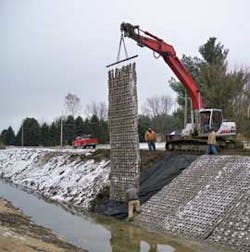
The Indiana Department of Environmental Management
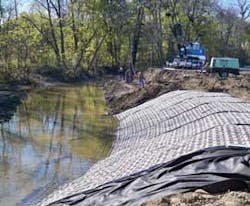
required articulated concrete block mats for the bridge.
channel-which had to be accomplished through sequencing-and lengthening a six-lane bridge on a major arterial road, used daily by more than 50,000 vehicles, to accommodate the widened portion of the Forester Creek channel.
By the end of the project, 17 storm drainage systems fed into Forester Creek along the project alignment through outlets constructed of 3,000 linear feet of reinforced concrete storm drain pipe ranging in size from 18 to 54 inches.
Widening the channel meant lengthening the Mission Gorge Bridge to twice its size, which consumed a large portion of the extra costs. Included in that was the construction of a new four-slab bridge at Olive Lane to connect residential neighborhoods on each side of the creek.
The channel had to be widened to 200 feet-three times its original size-to accommodate stormwater flows. The depth of 10 to 15 feet was retained, as well as the creek’s slope.
Widening involved heavy equipment use and grading. The widening also entailed diverting water from one side of the channel to the other through digging a second parallel channel.
Articulated blocks were used to reinforce the channel bottom. Enviroflex, manufactured by Soil Retention Inc. of Carlsbad, CA, helps provide erosion resistance while adapting to ground movements and grade changes. Openings in the block units allow vegetation establishment.
The mats that were used had about a 20% open area
through which vegetation could grow.
Bonded fiber matrix containing emulsified wood chips and other materials was sprayed to hold the new banks in place and control erosion.
The entire excavation procedure produced 350,000 cubic yards of fill, which Caltrans used to build SR-52 overpass embankments.
Project improvements slowed water flow from 20 feet per second (fps) to 3 fps through Santee. Not only did that help to manage construction conditions, but it will also go a long way in reducing long-term erosion by natural desilting and filtering processes through the wetlands restoration.
The dissipation of the upstream water velocity and energy was achieved through the construction of a 100-meter-long riprap energy dissipater. To control erosion during construction, a series of riprap check dams consisting of small boulders 1 to 3 feet in diameter were constructed in a horseshoe shape in the channel.
Archer Western Construction diverted low-flow creek water to pump wells, where it was filtered through 0.75-inch rock and filter fabric before being pumped through active construction areas to downstream discharge points. Santee officials sampled water quality to check turbidity and sediment levels within the creek.
To help ensure the improvement of water quality, a trash collector was installed at the unlined portion of the channel at the El Cajon border to remove refuse before it enters the Santee creek area.
Additional pollutant removal is expected through the oxygenation of the water through the native plantings and the decreased turbidity brought about by slower flows. A reduction in hydrocarbons, metals, nutrients, and fecal coliform is expected.
Prior to embarking on the project, Santee city officials and consultants prepared an environmental impact
The newly restored Forester Creek channel can accommodate a 100-year flood.
report (EIR) for the project, which included a survey of the creek area and the development of a GIS database to estimate the impact of the project on the wetland habitat.
EIR results showed the area to be of low urban quality. The expectation was that a five-year follow-up analysis would yield significant differences.
Procopio is pleased that two statistically significant results occurred after the project’s completion.
“With respect to the success of the project, we’ve received some new information from our post-project water-quality bioassessment,” says Procopio. “We’re showing a 69% decrease in fecal coliform bacteria through the project. That’s a huge decrease, because Forester Creek is actually listed as impaired for bacteria.”
And while the news doesn’t necessarily take the creek off the impaired list, it will go a long way in helping Santee to achieve that goal, Procopio points out.
Additionally, the bioassessment revealed that the stream’s water quality has improved so much that it is just above the impairment threshold for the Index of Biotic Integrity (IBI) score.
“Prior to restoration of the creek, the IBI score was 10,” says Procopio. “After creek restoration, the IBI score was 28, which is above the impairment threshold. The stream bioassessment report prepared by Weston Solutions in June 2008 states, “˜It is quite notable that urban-influenced streams in San Diego County rarely scored above the IBI impairment threshold,'” Procopio says.
“The IBI score went up so much that it’s above the impairment threshold, so the stream would no longer be impaired by the bioassessment standard,” she adds. “That’s a huge thing for us, because from what I understand from some of the biologists who spoke with us, it’s pretty rare in San Diego County to have this type of urban stream that isn’t impaired. It’s an indicator of success.”
Procopio believes the three goals that served as the foundation of the project have been achieved: to increase stormwater capacity in the creek to a 100-year flood protection level, to invigorate development of the area and save local residents and business from the need for costly FEMA-mandated flood insurance, and to restore the creek’s habitat while improving water quality.
FEMA gave Santee a conditional letter of flood map revision, while reviewing the hydraulic analysis for the floodplain area along the creek before the project commenced. FEMA was expected to update the Special Hazard Area maps after the project’s completion. As such, citizens out of the floodplain area will save money by no longer being required to purchase flood insurance.
Procopio indicates the capital improvement project also is expected to improve the city’s economy through the development of underutilized commercial property.
Aesthetics was also one of the drivers of the approach. “It’s not an ugly concrete channel that is a maintenance liability,” says Procopio. “It’s actually a nice place for people to sit. There’s an amazing amount of birds in there already.”
Procopio’s advice to other government agencies considering a natural vegetated approach to streambank repair: “It’s something everyone likes. The resource agencies like it, the residents love it, it’s good for water quality, it’s good for meeting our TMDL [total maximum daily load] requirements; so, I would say that there’s more than just the bottom line involved.”
The Forester Creek Improvement Project has gained the attention of regional water authorities and environmentalists, flagging the project as a model for future creek restoration projects in the San Diego area.
The birds that have flocked to the site are visiting a renovated area that includes 400 new trees, including sycamores and coastal live oaks. Santee will provide a five-year maintenance and monitoring program of the new plantings, letting nature take over afterward.
The Forester Creek restoration has won an award from the Association of Environmental Professionals for Outstanding Environmental Solution in recognition of a unique and technically advanced design/construction project to reduce or avoid adverse environmental effects.
Additionally, the Floodplain Management Association has toured the project twice, Procopio says.
“The new way to do flood control is this: environmentally friendly and aesthetically pleasing, with walking paths adjacent to a channel that is vegetated with all sorts of bird life,” she says.
Bridges of Madison County
A bridge in Madison County, IN, was in a state of disrepair. Bridge 87 is on County Road 700 North over Little Killbuck Creek, located northeast of Anderson, IN. The bridge being replaced was a 16-foot-wide steel truss bridge built in 1917.
Plans for the bridge replacement called for it to be widened to 32 feet. But that also entailed relocating the upstream side of the bridge, which came in at a sharp angle to the bridge.
“It worked for the 16-foot-wide bridge, but the stream was going to be underneath the abutment of the new bridge, so we had to shift 150 feet of the stream away from the bridge and bring it in at a better angle,” explains Chuck Leser, county engineer.
That required a creek relocation permit from the Indiana Department of Environmental Management (IDEM).
“The normal practice is to place riprap with filter fabric underneath it,” says Leser. But IDEM requires the use of articulating concrete block mats.
“One of IDEM’s concerns was to have grass growing on the banks of this new channel, and with riprap, you do not get grass growing through it,” says Leser.
After “shopping around,” Leser chose Submar Inc. in Houma, LA, as the supplier. The mats were set in fall 2008 as part of the bridge construction project.
“The first thing we did is clear the channel, remove the bridge, and relocate the channel,” says Leser. “Once we had the channel relocated outside the limits of the new bridge, then we had the mats brought in, and we set those and then seeded the banks.”
The relocation of the channel produced a curve in the stream-called Little Killbuck Creek-coming into the bridge.
The outside and inside curve bank needed to be protected from erosion. Therefore, approximately 3,550 square feet of UltraFlex Class M4540 articulating concrete block mat was chosen to provide the solution.
“The blocks come in different sizes, and that size block was what was engineered for this particular stream flow, the velocity, and the soil types,” says Leser.
After the stream was relocated, contractor A. K. Shannon Excavating of Gwynneville, IN, installed filter fabric and laid the mats on top, covering them with dirt and then seeding them. The mats have about a 20% open area through which vegetation can grow.
The job was to be completed by the end of May. Cold weather conditions-which shut down asphalt plants-prevented its completion, so in the fall, beams were set on the bridge and it was temporarily opened for the winter. Job completion calls for fixing driveways, yards, and roadway approaches.
Nonetheless, after the mats were put into place, and the area was seeded and strawed, vegetation soon started to grow.
There were no major challenges inherent in the job, Leser says.
“They installed very easily,” he says, adding that it only took a day to complete that part of the job. “The contractor lifted the mats one at a time off of the truck, set them on the ground, and then, when we were ready to place them, he picked them up with the crane, laid them on the bank, and we were done.”
Leser’s initial reaction to having to use the articulating concrete block mats was that it would cost the county a lot of money. But with the time involved in installing riprap-including excavation, installation, and hand work-Leser says, “I feel like it comes out the same cost-wise.”
Saving the Pallid Sturgeon
The endangered pallid sturgeon has been the focus of one of the largest river mitigation projects in the history of the US Army Corps of Engineers.
The pallid sturgeon once inhabited a natural side chute along the Missouri River system, but manmade channels eliminated these waters, leading to the sturgeon’s eventual risk of extinction.
A mitigation project 2 miles north of Rulo, NE, involved dredging side channels or chutes so the pallid sturgeon, a rare species, can spawn in its favored habitat of turbid water.
The project-called the Rush Bottom and Tarkio River Chutes-entailed dredging a chute using a swinging ladder dredge with the help of supplies from the Dredging Supply Company in Reserve, LA.
The project began in 2006 and was completed in spring 2008.
The completed chute is 8,200 feet long. It has a 75-foot bottom width and 1:1.5 horizontal side slopes designed to erode to a maximum width of 200 feet.
Western Contracting Corporation of Sioux City, IA, designed the swinging ladder dredge to easily shape the side slopes with minimum over-excavation, with the dredge cut at 100 feet wide at the top. Over time, the channel self-erodes to 200 feet, creating the environment needed for the varied flow conditions. The chute is connected to the river at both ends for continuous flow.
Dredging proceeded seven days a week in two 12-hour shifts. Dredging depth averaged 10.5 feet. In addition, a scraper pulled by a Caterpillar tractor was used to scrape off top material and vegetation, exposing the material to be dredged and making the process go faster.
“The fluctuating river flows were a huge challenge,” says Neal Everist, president of Western Contracting. “With flooding conditions on the project, we just had to wade through it. When we had high water, we would deal with it, but the number-one challenge without a doubt was flooding conditions throughout the duration of the contract.”
The company experienced two major floods during the job.
“When flooding occurs in this stretch of the river, we saw in a period of 12 hours the river rise 16 feet,” says Everist. “It typically takes two to three weeks for the water to recede to where we can go back to work. During two major floods, we were sitting on our hands for two weeks waiting for the water to recede.”
Short of the project’s completion, many fish species are returning to the cut channel.
Everist credits his crew for the project’s success.
“You can have the best idea and the best equipment, but you need people to take that idea with the equipment to have a successful job,” he says. “I’m very proud of [project manager] Devin Rowland and his crew.
“Out of the corps’ design and excellent Dredging Supply Company equipment, you mix in high-quality people who dredge 24/7. It’s not easy day after day after day, weekends and holidays, keeping that thing running.”
Everist says the project is one of dozens on the Missouri River between Gavins Point Dam and the mouth of St. Louis that the Corps of Engineers is constructing for the benefit of the fish and wildlife.
He adds, “The US Army Corps of Engineers does the designing and they go through their best judgment on how to create this habitat. We are happy to take their plans and build it to the design. Anything they can do to the benefit of the fish and wildlife is a good thing.”