Many techniques are available to stem erosion of streambanks, to prevent flood damage, and to help restore the natural function of a stream or creek. This article looks at several different examples.
Underwood Creek
Located in metropolitan Milwaukee, Underwood Creek is a major tributary of the Menomonee River. Dale Miller, principal of Mainstream Restoration, noted in a project report that “Partly due to the high degree of urbanization in the watershed, Underwood Creek was physically altered in the mid-1960s to provide flood management, which included channel widening and realignment, and the installation of concrete lining and drop structures along a significant portion of Underwood Creek.
“Channel alterations successfully reduced peak water levels in some areas, but contributed to flooding conditions along portions of the Menomonee River. In addition, the modifications entirely disrupted channel and floodplain functions. Aquatic habitats were completely eradicated during installation of the concrete lining and associated filling within the floodplain.
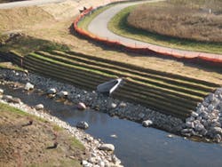
“As part of a comprehensive plan to restore watercourses within the watershed, the Milwaukee Metropolitan Sewerage District developed plans to rehabilitate 6,600 feet of Underwood Creek by removing the concrete channel lining where feasible, creating a more natural, rock-lined channel with riffle and pool sequences, reestablishing a functional floodplain by removing fill adjacent to the channel, and reestablishing plant communities within the newly created floodplain. Phase 1 of this effort, involving 2,400 feet of stream and associated floodplain, was constructed in 2009.
“One of the most critical design elements involved determination of channel geometry. The Underwood Creek hydrology is typical of highly urbanized watersheds: very low base flows, more frequent moderate flows with short duration peaks, and extreme high-magnitude flood flows. Channel dimensions and this range of seasonal flows together dictate the frequency, duration and water depth of floodplain inundation. Inundation characteristics affect the composition, diversity, and health of the riparian plant community that will reestablish on the restored floodplain. Simultaneously, the amount of water in the channel affects aquatic habitat, water quality, and whether the stream appears natural.”
Miller explains, “What we ended up doing was removing about 10 feet of fill material in the floodplain to bring the floodplain down, and removing the concrete lining, and reconstructing a meandering channel with a more functional and natural condition.
“The bulk of the streambank was reconstructed using a stone toe and an upper bank that would be revegetated, and it was constructed out of woven coir and nonwoven coir fabric that was wrapped around soil. The bulk of the streambank was constructed using that bioengineering technique.”
Miller’s report on the Underwood Creek project describes this process in further detail. “The streambanks were constructed by wrapping dual layers of woven (700 grams/square meter) and nonwoven (loose coir in a cotton/jute biodegradable net) coir fabrics around a 12-inch-thick core of soil. This method is known as fabric-encapsulated soil, or FES, and has proven to be very resistant to flows immediately following construction-yet eventually supports herbaceous and woody vegetation. The coir was held in place using wedge-shaped wooden stakes. The floodplain surface consisted of a 1-foot layer of topsoil covered with woven coir fabric and staked in place to provide temporary erosion control. These stakes are evident before vegetation becomes established.”
Asked if other BMPs were considered and then rejected, Miller says, “Not really. We kind of knew what we would end up using going into this project. This project is located in Milwaukee, and the client is Milwaukee Metropolitan Sewerage District, and they have used this technique quite a bit on other projects. So they were well aware of it, and it’s actually a technique that I helped develop in 1992 for a project in New Jersey, and I have implemented it in lots of different states. It’s a practice that’s been picked up by others, and used and modified, so it’s used all over the place.”
Miller adds that the Presto Products Geoweb channel protection system was also used in some locations, “both where erosive energies were a lot higher and where there were transitions from softer approaches to existing concrete infrastructure.”
In two locations, he says, streambanks were constructed from stacked geocell. “What this essentially means is putting in horizontal layers of geocell in a stacked configuration or a layered configuration. Geocell is a heavy plastic material that is in the shape of a honeycomb, about 8 inches high, and they expand like an accordion. They can be backfilled with material and they retain their shape. I think they were originally designed for creating roads in deserts for desert warfare, so you can basically expand them, fill them with sand, and drive over them. It provides lateral stability.”
He notes that a typical application for geocell is to lay it on the ground and backfill it. “Another application is to put these in horizontal layers with an offset slope to construct a vertical streambank. They’re very stout because they’re built back into the slope. We backfilled them with a combined material that’s coarse (like gravel) so that it doesn’t wash out and provides a little armor in each cell. The other component is topsoil. If we would just fill it with topsoil, the topsoil would potentially just wash out.
“That growing medium then provides a framework for seeding and planting. In this particular case, we also wrapped each geocell layer with woven coir fabric that provided added insurance that we could keep the materials in the geocells before the vegetation could become established.”
The woven coir wrapping each geocell layer is fully biodegradable, Miller says, and typically breaks down in two to four years. He previously used the Geoweb system on another section of the Underwood Creek project further downstream, several years ago.
Miller primarily used coir fabric wrapped around soil to construct the streambanks, but he explains under what conditions he chose to employ the Geoweb system. “It’s for more highly erosive conditions-higher velocities and higher shear stress. I think, for example, the design discharge for the Underwood Creek project was rather high. The 100-year event was 6,870 cfs-that’s a lot of water.”
Extensive revegetation was required. “The majority of the site was planted and seeded in 2009 concurrent with the channel and floodplain construction,” Miller notes. “Seeding included seedbed preparation, broadcasting of a floodplain seed mix, and planting of trees and shrubs in areas that would be frequently inundated. Herbaceous and woody species planted on the floodplain ranged from facultative to obligate wetland plants, allowing for the variable moisture in elevations of the newly graded floodplain.”
St. Francisville Levee
In St. Francisville, LA, just above Baton Rouge, the US Army Corps of Engineers maintains a casting field, where it produces articulated concrete block (ACB) mats. The property lies adjacent to the Mississippi River.
Don Rawson, chief of the Channel Stabilization Section for the corps’ New Orleans District, explains the area. “We had a 210-acre casting field, and the whole field was protected with levees. We were looking for various devices to armor levees against overtopping. We tested about a 100-foot reach of material with each of four different products-three turf reinforcement mats and the articulated concrete block mats.
“We had put articulated concrete mats in the river to protect the river from scouring. We had a levee up there that we could use as a test levee. It just protects the casting field from flooding. It doesn’t have any other purpose. We could do things with that levee that wouldn’t impact anyone else.”
The ACB mats utilized for the test were open-cell Shoreblock SD units from Shoretec. This product was selected for testing based on its hydraulic performance, easy maintainability, and vegetative growth through the open cells.
As it turns out, within a few months, the area sustained flooding of the Mississippi. “I think it took about 18 hours for the casting field to fill. We had 3 to 4 feet of water over the top of the levee,” Rawson says.
The ACB field had been well vegetated at that point and suffered no damage from the force of the flooding water.
Rawson adds, though, that water velocities achieved didn’t really sufficiently challenge the test areas in the manner the corps is looking for. “What we’re testing is wave-overtopping as well as surge. We’re testing critical flows, but we’ve never had a combination of waves and surge tied in together.”
Shoretec notes, however, that studies by the Federal Highway Administration have indicated ACB stability at wave heights of 10 to 11 feet, depending on the weight of the block. Typically a 4-inch block weighing 30 to 40 pounds can withstand wave attacks of 4 feet.
Along the Kentucky River
Over time, streambank erosion can produce steep banks with little or no vegetation. These unprotected banks are then susceptible to further erosion due to the loss of ground cover, groundwater discharge, and erosion at the base of the streambank. Sometimes the loss of vegetation occurs more suddenly, however, as happened along the Kentucky River in downtown Frankfurt, KY.
Strong storms and record water levels caused the total dislocation of an immense sycamore tree on the riverbank. The 150-foot-tall tree had a 5-foot trunk diameter and weighed over 12 tons. The cavity formed by its removal caused significant damage to the streambank.
A-Jacks units were used in repairing the damage. Made by Armortec (now a subsidiary of Contech) the A-Jacks units are concrete structures shaped like a child’s toy jacks. They are designed to interlock into a flexible matrix that is highly permeable due to the shape of the units, but they can also be placed in a random manner.
According to Contech, the voids formed within the A-Jacks matrix provide approximately 40% open space when constructed in a uniform placement pattern. These voids can provide an excellent fish habitat, or can be backfilled with soil and seeded with a variety of vegetation.
At the Kentucky River site, there was a 90-foot-long embankment, with a 1:1 slope, from the water level to a parking lot above. After the tree was removed, a flat trench was prepared in the area. Filter fabric was laid on a 12-inch bedding layer of crushed stone, onto which a series of layers of A-Jacks was placed. Additional stone backfill was placed behind the A-Jacks. Native soils obtained from the trench excavation were also used as backfill to help provide a matrix for vegetative growth surrounding the A-Jacks, further stabilizing the damaged streambank. Not only was the riverbank strengthened, but the parking lot above the embankment was also spared ultimate breakdown.


