The tide of appreciation for wetlands is rising. It has come along with an understanding of how effectively they function in controlling erosion, flooding, and pollution from stormwater. Sadly, many acres of valuable US wetlands, especially coastal, have been lost in recent years.
EPA defines saltwater and freshwater wetlands as “coastal” when they are within US Geological Survey (USGS) eight-digit hydrologic unit watersheds that drain in the Gulf of Mexico or the Atlantic or Pacific Oceans. Coastal wetlands cover about 40 million acres and make up 38% of the total wetland acreage in the coterminous US. Eighty-one percent of these wetlands are in the southeastern US.
A few years ago, the US Fish and Wildlife Service (FWS) and the National Marine Fisheries Service of the National Oceanic and Atmospheric Administration (NOAA) published Status and Trends of Wetlands in the Coastal Watersheds of the Eastern United States. This report revealed a disturbing trend. While wetland areas increased nationally between 1998 and 2004, coastal wetlands-mainly freshwater-were decreasing rapidly.
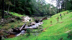
A dam that was later removed
During this time, 299,540 acres of freshwater wetlands and 61,560 acres of saltwater wetlands disappeared. The overwhelming reason-true for almost 70% of the losses-was development of formerly natural areas.
Coastal wetlands were also drained for agriculture and silviculture. Storms and sea level rise that changed wetlands to open water also caused wetland losses.
The FWS and NOAA report prompted EPA to set up the Coastal Wetlands Initiative. The program is a partnership with FWS, NOAA, the US Army Corps of Engineers, USGS, the Federal Highway Administration, and the US Department of Agriculture’s Natural Resources Conservation Service (NRCS). Its goals are to measure wetland loss, better understand why it happens, and prevent it. The initiative will share strategies and information with state and local agencies and private entities to use in protecting and restoring wetlands. It will also work to raise awareness of the value of wetlands.
The Coastal Wetlands Initiative’s first major task was preparing its recently published reviews on wetlands in seven focal watersheds. The reviews were arranged regionally: North Atlantic, Mid-Atlantic, South Atlantic, and Gulf of Mexico. For more information see http://water.epa.gov/typewetlands/cwt.cfm. (Funding was not available for the West Coast region.)
Compared with the other three regions, the North Atlantic region (Maine, New Hampshire, Massachusetts, New York, Rhode Island, and Connecticut) had much less loss of coastal wetlands. One reason is strong laws in place, particularly in Massachusetts.
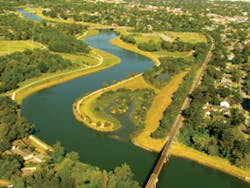
Aerial view of marsh alongside Brays Bayou
In Massachusetts, state environmental laws are generally stronger than federal laws. And where local municipalities have relevant regulations (about one-third), these are often more stringent than the state’s.
The Massachusetts Wetlands Protection Act protects not only inland and coastal wetlands, but also 100-year floodplains, isolated wetlands, beaches, dunes, and banks. The state was the first in the US to pass legislation to protect coastal wetlands, in 1963.
Some Massachusetts towns, such as Falmouth, require that developers pay for the local conservation commission (mostly citizen volunteers) to hire its own wetland consultant to help review plans for proposed developments. Such a law protects the town from poor decisions by commission members who lack expert knowledge and ensures the consultation even if the town doesn’t have the funds to hire the wetlands expert.
Massachusetts also has the advantage of a Wetlands Loss Mapping and Enforcement program. It is administered by the state’s Department of Environmental Protection (DEP). Producing the maps costs about $85 per square foot.
This system links a database of permits with wetland losses observed on aerial photos. If the photos show loss that doesn’t match a permit, it is flagged as a potential violation and investigated. The DEP not only fines violators and publicizes that fact but also requires restoration and/or mitigation. Since the project began, wetland acreage lost has been reduced by about two-thirds.
Because most members of local conservation or planning boards are citizen volunteers, not professional hydrologists, the Massachusetts DEP also created a program to provide expertise on decision-making that will affect local wetlands. The Wetland Circuit Riders are experts on wetlands. They work somewhat like old-time preachers or judges who traveled to serve several towns in turn. The Massachusetts Environmental Trust provides funding for these circuit riders, who consult by phone and also attend evening commission meetings. Some towns schedule joint meetings of their commissions so the Wetland Circuit Riders can help several communities at once.
Another factor in wetland preservation and restoration in Massachusetts is the state’s strong dam removal policy. The EPA report terms its Dam Removal Guidance “a model for other states.”
Massachusetts’s Cape Cod watershed includes the Elizabeth Islands, Nantucket, Martha’s Vineyard, and the entire Cape Cod peninsula. Besides the sand dunes and beaches, the watershed includes salt marshes, wooded swamps, wet meadows, bogs, and pine barrens. The coastal landscape draws a rapidly increasing population. Most of the residential sections and some commercial sites are not connected to municipal sewer systems, but have septic systems onsite.
Besides development, agriculture-cranberry growing-is most responsible for loss of wetlands in Massachusetts. Most of the state’s cranberry bog farms are in the southeast sector. Cranberry bogs accounted for 50% of wetland loss from 1993 to 2005 and more than 20% of loss from 2005 to 2009, according to the DEP.
Eel River
The Eel River headwaters at Plymouth, MA, were once wetlands, and the river flowed uninterrupted to the ocean. In the early 1800s, settlers built mills and dams. Cranberry farming began in the late 1800s and continued until 2002.
Past agricultural activities resulted in the removal of trees, modification of the stream channel, and construction of upland berms and water control structures. The downstream dam was a barrier to fish migration. Wildlife habitat and water quality deteriorated.
Naturalizing approximately 40 acres of former cranberry bogs and reconstructing a 2-mile natural stream channel was a complex operation. It took five years to complete. Workers had to add pieces of timber and other items to create an improved in-stream habitat, fill in artificial side channels, and replace undersized culverts. They installed over 24,000 plants, including more than 17,000 Atlantic white cedar trees.
Water control structures such as berms and Sawmill Pond Dam, a large stone dam downstream of the bogs, were removed to allow fish passage. A new river channel and floodplain naturally reformed in the vacant space.
In 2006, Plymouth’s Community Preservation Committee had purchased cranberry bogs from the Phoenix Cranberry Corporation and converted the entire area to public conservation land. Now known as the Eel River Preserve, the land is managed by the Town of Plymouth for public use and benefit.
The NRCS provided nearly $600,000 in federal Farm Bill funding for conservation easements and a portion of the restoration costs for the Eel River Preserve through the Wetlands Reserve Program. Most of the funding came from a US Fish and Wildlife grant.
“The restoration of the headwaters of Eel River is one of the most ambitious coastal restoration projects completed to date in New England,” said Mary Griffin, commissioner of the Massachusetts Department of Fish and Game, at the project’s dedication ceremony.
Wayne Klockner, executive director of The Nature Conservancy in Massachusetts, said that projects such as the Eel River restoration “are critical to preserving habitat, protecting our drinking water, and providing recreational opportunities for local people.”
Flood Control in Texas
Coastal wetlands in the Gulf of Mexico region differ in stressors and types of loss from those in the North Atlantic region. Development still erases wetlands, but hurricanes and storms also cause a great deal of loss. Channelization, dredging, and oil-and-gas extraction are also factors.
From Louisiana to Mexico, the Texas coastline measures more than 360 miles. But counting shorelines around bays, islands, and creeks equals much more distance, in an ecologically diverse region.
The two Texas watersheds that drain into the Gulf of Mexico are East and West Galveston Bay. Combined, they cover 27,000 square miles of land and extend up the Trinity River to the Dallas/Fort Worth area. Almost half the population of Texas lives with these two watersheds. The West Galveston Bay watershed includes Harris County, within which the city of Houston is located.
The heavily urbanized Brays Bayou watershed drains parts of Houston and several neighboring towns. It covers about 127 square miles and includes 121 miles of streams. During the early to mid-20th century, several damaging floods occurred along Brays Bayou. To reduce the risk of flooding, the US Army Corps of Engineers implemented a major flood damage reduction project along the bayou from 1957 to 1968. Over the years, the completed project has significantly reduced flood losses, but flooding risks still exist. Since the completion of the project more than 30 years ago, there have been six significant floods along Brays Bayou.
Harris County Flood Control District has built two major projects to control flooding and stormwater runoff. Both include wetlands that also bring much-needed wildlife habitat and recreational opportunities to city locations.
The Brays Bayou Flood Damage Reduction Project, also known as Project Brays, is a partnership project between the Corps of Engineers and the Harris County Flood Control District (HCFCD). Project Brays includes 21 miles of channel improvements, several stormwater detention basins, and environmental enhancements along Brays Bayou and some of its tributaries. The project begins at the Houston Ship Channel and extends upstream over 30 miles.
The wetlands section, Brays Bayou Marsh at Mason Park, is a constructed freshwater tidal marsh of about 3.5 acres. It will improve water quality by removing pollutants from the runoff entering the main channel.
The Greenway at Willow Waterhole is a joint project among the HCFCD, the city of Houston, and the Texas Parks and Wildlife Department to create park and recreational amenities on up to 250 acres when they are not being used for temporary stormwater detention.
This part of Project Brays will be linked to other areas of the Brays Bayou watershed with trails being developed by the city of Houston and Harris County.
Upon completion, the project will remove tens of thousands of homes and commercial structures from the 100-year floodplain. The project includes replacement or modification of 32 bridges, channel conveyance improvements, and stormwater detention ponds.
The total cost for Project Brays is estimated at $450 million dollars, with the federal government and the HCFCD paying approximately 50% each. Project Brays is scheduled for completion in 2014.
HCFCD’s Greens Bayou Wetland Mitigation Bank is located 5 miles southeast of Bush Intercontinental Airport, at the confluence of Garners Bayou and Greens Bayou. The project offers much needed wildlife habitat in an urban location.
Many migratory waterfowl will take advantage of this site. It includes a 108-acre stormwater detention pond, forested wetlands, and a littoral marsh. This wetland mitigation bank will cover 1,400 acres when it is finished. It offers wetlands for mitigation to construction elsewhere and improved water quality through natural treatment of runoff.
North River Farms
EPA’s report on South Atlantic coastal wetlands focuses on eastern Florida, Georgia, and the Carolinas. This region has the highest wetland density of the entire East Coast. It also has types of wetlands not found elsewhere, including cypress swamps and mangrove forests.
According to EPA’s review of coastal wetlands, North Carolina has about 5,000 miles of estuarine shoreline and more than 300 miles of ocean shoreline. The state has lost about half of its original 11.1 million acres of wetlands to forestry, agriculture, and development.
Now both North Carolina and Florida have statewide wetland mitigation programs. North Carolina’s Ecosystem Enhancement Program offers in-lieu fee mitigation. EPA terms it “one of the most innovative government programs in the country due to its proactive, watershed-based approach.”
One of North Carolina’s most interesting and innovative wetland projects is North River Farms, located in eastern Carteret County. This ongoing project will be one of the largest wetland restorations in the state. When finished, it will have about 5,000 acres of restored wetlands and 1,000 acres of preserved land.
Formerly the site of a large agricultural operation-with attendant runoff-the land is now managed by the North Carolina Coastal Federation (NCCF). This nonprofit organization partnered with various federal and state agencies to purchase and then restore the area to its pre-agriculture state.
Todd Miller, NCCF’s director, says the most challenging part of the project has been “a lot of heavy-duty construction and raising the money to buy the land. We’ve had a huge amount of good help along the way, though.”
When North River Farms is finished, it will be more accessible to the public. With its rich habitat, it offers good wildlife viewing. The local Audubon Society has conducted its Christmas Day Bird Count there every year since 1999.
Negotiations over the property began in 1998, when NCCF acquired 1,991 acres at the rear of the property with the help of a $1 million grant from the North Carolina Clean Water Management Trust Fund. At the time, approximately 808 acres were being used as farmland, with the remainder designated prior converted cropland. Through a partnership with the Ecosystem Enhancement Program and North Carolina State University, as well as funding from EPA, NOAA, and USFWS, the entire area was restored at a cost of approximately $1,100 per acre.
A few years later, in 2000, a private mitigation banking company, Restoration Systems LLC, purchased 400 acres adjacent to the NCCF property, while NCCF negotiated the purchase of the remaining farm acreage (3,568 acres) for around $1,400 per acre.
1804 Wildlife Partners, a private hunting club, bought 1,400 of the 3,568 acres. NCCF agreed to sell in return for 1804 Wildlife Partners’ commitment to place the land in NRCS’s Wetland Restoration Program (WRP) and restore it to natural state. With the partnership in place, NCCF applied for and received $3 million from the Clean Water Management Trust Fund. The purchase of this section was made in 2002.
Part of the second acquisition included a farm lease on 2,100 of the acres. That lease will expire at the end of this year. Plans are ready to turn that acreage back to wetlands as soon as the growing season is over.
The size and scope of North River Farms makes it a splendid site for wetlands research. Faculty and students from NCSU and officials from the Duke University Marine Lab and the North Carolina Wetland Restoration Program are involved with various design and research projects onsite.
One research project was a comparison between the simplest and least expensive methods of restoration with more complex and expensive ways. Miller was pleased that the hydrologists found no significant difference, which will allow more work to be done in less time. “You don’t have to spend huge amounts, but you still get the hydrology you need,” he says.
“North River Farms is clearly on the edge of the estuaries; its creation is like having a big sponge to absorb stormwater,” Miller notes. “In the past, it would take months for the water to drain. Now, in a couple of hours, it’s absorbed.”
All of that volume of runoff meant too much fresh water downstream, which caused “rapid changes in salinity of water,” Miller explains. “Now we’re seeing some improvement in downstream waters, where there is shellfishing.”
He adds, “We’ve sampled the water for nutrient reduction, and we’ve seen a real effect” since the wetlands were restored.
A project the size of North River Farms is difficult to accomplish because the size of funding requires that many different agencies be involved. Listing the partners of North River Farms proves the point: Its financial supporters include the Clean Water Management Trust Fund, the Ecosystem Enhancement Program, NOAA’s Community-Based Restoration Program, Restore America’s Estuaries, the North American Wetlands Conservation Act, Fish America Foundation, the North Carolina Attorney General’s Office Environmental Enhancement Grant, USFWS, the National Fish and Wildlife Foundation, 1804 Wildlife Partners, Restoration Systems, the North Carolina Coastal Land Trust, the North Carolina Natural Heritage Program, The Nature Conservancy, and Open Grounds Farm.
North River Farms is also serving as a demonstration and public education tool, helping North Carolina coastal agricultural community members learn about restoration as an option for their land. Such positive influence can be pervasive.
EPA’s report notes that review participants from the South Atlantic region spoke of a growing focus on restoring prior converted croplands back to their original wetland state. This strategy mitigates agricultural impacts to coastal wetlands and improves water quality.
Neuse River
The Neuse River flows for more than 250 miles, from central North Carolina eastward to the Albemarle-Pamlico Sound. Years of runoff from agricultural operations, including large hog farms, have affected its waters.
Appropriately, funding sources used in the Neuse watersheds include the Farm Bill and Conservation Reserve Enhancement Program. The Farm Bill funds the Wetlands Reserve Program to pay for acquisition, easements, and restoration of prior converted lands. Conservation Reserve Enhancement Program money is also available for prior converted land restoration within the Albemarle-Pamlico Estuary river basins.
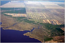
Aerial view of North River Farms
Among the wetlands projects in the Neuse River watershed are two unusual ones.
Jack Smith Creek Stormwater Project is a water-quality partnership project between the city of New Bern, the North Carolina Ecosystem Enhancement Program (EEP), and the North Carolina Clean Water Management Trust Fund. The project involves the construction of a stormwater wetland to capture and treat runoff from a large watershed in New Bern. The wetland was proposed as an environmental initiative by the city, and as a part of the EEP Nutrient Offset Program.
It features a concrete, W-shaped weir. When the plants that were installed in 2013 reach maturity, this wetland will have the ability to treat runoff from more than 1,000 acres of residential and commercial property.
The project is one of the largest stormwater retrofits in the state to date. It will intercept stormwater before it reaches the Neuse River, less than a mile away. Designed by the Biological and Agricultural Engineering Department at North Carolina State University, the project offers hands-on research opportunities for students and faculty.
The city of Goldsboro is also on the Neuse River. On the grounds of its water reclamation facility is a 40-acre constructed wetland that includes more than 52,000 wetland plants of 13 different native species. This constructed wetland complex has four different zones: shallow mixed marsh zone, deep mixed marsh zone, transition, and littoral. Between 1 million and 4 million gallons per day of advanced treated wastewater flow through the wetlands for a final “polish” to remove nutrients.
The water entering the constructed wetlands has on average 3 mg/L total nitrogen. The resulting polished water has less than 1 mg/L total nitrogen remaining in it prior to being discharged in the Neuse River.
The constructed wetlands project cost $3.3 million to build. The North Carolina Clean Water Management Trust Fund provided $1.6 million in grant funds.
As the use of green infrastructure becomes more prevalent in urban and rural areas, it is obvious that wetlands have a place in erosion and stormwater control. And because wetlands have inherent wildlife habitat and recreational benefits, it’s easy to convince taxpayers of their benefits.


