Built in 1938, the municipally owned City Marina is the heart of Fort Pierce, FL. Located by a park, the farmers’ market, the public library, condominiums, and the downtown area, the marina draws local residents as well as visitors who come by boat.
Fort Pierce is a major destination for people who want to catch fish and catch different species of fish. That’s because of its proximity to both the Atlantic Ocean and the biologically diverse shallow waters of the Indian River Lagoon. Fishing and fishing tournaments contribute significantly to the local economy. Any damage to the City Marina is a direct hit to businesses in Fort Pierce.
The marina’s entrance to miles of open water meant that it was in the perfect storm of a location if a storm came at a particular angle. That disaster happened in 2004, when Hurricane Frances hit the area and was followed by Hurricane Jeanne just three weeks later.
Hurricane Frances caused $13 million worth of damage to the 138-slip floating outer dock of City Marina. The damage bill for the boats that had been moored there totaled almost another $15 million.
Rebuilding City Marina was an easy decision for Fort Pierce officials to make. But they knew that doing it correctly would not be easy or inexpensive. Materials cost far more than when it was originally constructed, and environmental regulations from numerous federal and state agencies had proliferated over the years.
“We wanted something that would not be an eyesore, that would benefit the lagoon, and that also had a function,” explains Ed Seissiger, engineering project manager for the city of Fort Pierce.
It would take a lot of time and money to meet the challenges of creating a new marina that would be protected from storms while not having a negative impact on the habitat of fish and wildlife. Those requirements held for both the construction period and afterward.
“We had to jump through a multitude of permitting hoops,” Seissiger says.
The last permit needed came from the US Army Corps of Engineers in 2011. The corps had delayed granting approval, pending review of how seagrass beds would be affected. Seagrass beds are important marine animal habitats, and Florida has lost many acres of seagrass.
Construction was done using shallow water barges, both to ferry materials and to serve as work platforms for workers and materials. This precaution was taken to prevent damage to the fragile surrounding ecosystem.
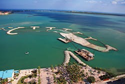
Aerial view of the marina at Fort Pierce
The new marina will enhance habitat for fish and many other types of wildlife. It has added 1.28 acres of new oyster beds, 6.26 acres of reef habitat, 2.22 acres of coastal dunes, 2.33 acres of shorebird habitat, and 1.54 acres of mangroves. That’s in addition to 8.12 acres of seagrass beds. Perches and stakes were added to encourage shorebirds to roost on the manmade barrier islands of the new marina. The natural fertilizer they leave promotes growth of the environmentally important seagrass.
The new marina’s entrance is more sheltered than was the old one’s. To new docks and slips, the project added manmade barrier islands-one large and 12 surrounding smaller ones as well as a peninsular structure-to protect the marina from wind and wave damage in a 100-year storm.
The main barrier island measures 10.5 acres. It is composed of tee groin stabilized crenulated beaches on the windward side, a coastal sand dune in the center, and a bench for an oyster bed and mangrove planting along the leeward side. Creating this structure required about 10,700 linear feet of geotextile containment tubes (Maccaferri’s MacTubes, 30 feet and 45 feet in circumference), scour apron (MacScour), geotextile bags (MacBags), MacMarine Mattresses, and about 35,000 tons of limestone armor.
Tetra Tech, the project’s engineering firm, used MacTube OS500 geotubes, made of high-tenacity polypropylene yarns. These yarns are woven so that they stay in position relative to each other. The material is inert to biodegradation and resistant to most naturally encountered chemicals.
Four different tube configurations were put in place. Single tubes were used in shallow water spots in the central portion of the island. Two-tier configurations were used in deeper sections.
To create the oyster bench and dike, a single 45-foot-circumference bottom tube and a top layer of sand bags were used along the island’s perimeter. Another two-tier grouping in deeper water joined two base tubes and a single top-tier tube. A pyramid stack of tubes 30 feet in circumference made up the structural core of tee groin No. 1. A pyramid stack of 45-foot-circumference base tubes was installed along the leeward side to maximize the oyster bench area.
The smaller barrier islands are of limestone placed over marine mattresses. The final design is one of 18 for which models on a 1:40 scale were built. The models were tested in tanks at Queens University in Canada to see how they stood up to simulated hurricanes.
Seissiger says the most challenging part of the project was filling the geotubes with sand in the midst of currents up to four knots. The contractor, Fish Tec of Ormond Beach, used a different method than usual.
“Normally you would have a piece of fabric underneath the tube, and to either side of the tube is an anchor tube. You use strapping to hold the main tube in place,” Seissiger explains. “We went away from using an anchor tube. We used 4-inch steel pipes and attached a tube onto them, tying them tightly. As the sand filled, we loosened the ties.”
The Federal Emergency Management Agency (FEMA) paid the $18.8 million cost of the barrier islands part of the new marina. Replacing the damaged slips cost another $11 million, which was paid by the state, FEMA, and insurance companies.
The state of Florida has issued a two-year moratorium on any similar construction for marinas while data are collected to see if this type of construction is a good alternative to shoreline hardscapes. During that time, the Florida Department of Environmental Protection will monitor the new Fort Pierce City Marina closely.
“They’ll look at subordinance or failure, scour, the [health of] benthic communities-seagrasses, juvenile fish,” says Seissiger. “We’re changing the dynamics in the lagoon. That’s 180 million pounds of rock we’re putting into that area.”
If all goes as expected, the new Ft. Pierce City Marina will be the inspiration for marina construction and rehabilitation in Florida and elsewhere. This is especially likely in environmentally sensitive areas where marine habitat must be considered.
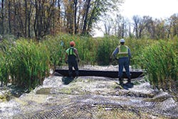
Geogrid material was used beneath this berm to stabilize it.
Aransas National Wildlife Refuge
Aransas National Wildlife Refuge lies along the Gulf Intracoastal Waterway on the Texas Gulf Coast, about 35 miles northeast of Corpus Christi. The waterway is a busy shipping channel, important to the regional economy.
Mild winters attract more than 400 species of birds to the refuge, most of which lies behind Matagorda Island, part of a long chain of barrier islands extending down the Texas coastline. Because the habitat is diverse, the refuge attracts a great variety of wildlife.
The saltmarsh habitat is perfect for some species of crab and fish. Farther inland, where salt and fresh waters mix, is habitat for shellfish and crab, food for whooping cranes, herons, and other wildlife. The freshwater sections provide ideal surroundings for amphibians and other wildlife.
Whooping crane habitat losses at Aransas were occurring at a rate of about 2 acres per year. This loss resulted both from storms and from increased shipping traffic on the Intracoastal Waterway. The number of whooping cranes fell to nearly extinct status in the 1940s, and the species is still recovering. Preserving their habitat, which is essential for their survival, would require controlling erosion along 73,000 feet of shoreline at Aransas.
The project was constrained by budget and site restrictions to protect the refuge. The work had to be done within three years. The major constraint was that construction could be done only from April 15 to October 15 of each year, before and after the whooping cranes arrived for their seasonal occupancy.
This was a complex project with potential impact on wildlife, habitat, and economic interests. It necessarily involved multiple partners, starting with staff with the Aransas National Wildlife Refuge.
State agencies involved included the Texas Water Development Board and Departments of Transportation and Parks and Wildlife. Federal agencies included the Coast Guard, the Fish and Wildlife Service, the National Marine Fisheries Service, and the US Army Corps of Engineers.
Despite the tight schedule and other constraints, the project was completed in 1999, on time and even under budget. Its cost of $17,900,000 was 100% from federal funds, based on the Endangered Species Act of 1973.
Articulated concrete blocks (ACBs) connected into a Petraflex mat were chosen as the permanent structure to control erosion. The 1,700,000 square feet of blocks were Shoreblock BD Series open-cell mats from Premier Concrete Products. The contractor was Kingfisher Marine Services.
ACBs have the flexibility to mold into the contour of the shoreline. These mats could protect against erosion and also allow vegetation to grow. That was critical because whooping cranes feed at the water’s edge.
Geotubes were modified for use as a breakwater. They allowed seagrasses near the shoreline to remain intact while providing erosion protection for 10,000 feet of vulnerable areas.
“The articulated concrete mat has done a great job in protecting the shoreline from erosion and stopping the loss of critical whooping crane habitat found on Aransas National Wildlife Refuge,” says Felipe Prieto, a wildlife specialist at the refuge.
As for the lasting effect of the project, Prieto says, “The marsh vegetation has been preserved and able to grow back in those areas previously affected [by erosion]. Today, some 13 to 14 years later, the marsh habitat looks good and continues to support whooping cranes.”
One unexpected concern, Prieto notes, is some damage that has happened through no fault of the materials or construction. During storms and fog, barges and tug boats “pull to the west side of the Gulf Intracoastal Waterway, park, and ride the storm out along the refuge shoreline.”
The tug boats are pushing to stay in place during high winds. That puts strong enough pressure on the ACBs that, with repeated contact, they can wrinkle and even break. “These breaks compromise the integrity of the articulated concrete mat and its ability to continue to protect the shoreline from erosion,” Prieto says, noting the need to repair the breaks caused by the tugboats and barges.
He adds that for vessel and crew safety, “There may also be a need to create other designated anchor points for these vessels along the Gulf Intracoastal Waterway. It would help to increase the life of the articulated concrete mats, reduce maintenance costs over time, and continue to preserve these vital habitats for wildlife.”
Prieto adds, “Protecting this habitat from erosion is very important and much needed for the benefit of the whooping cranes and other wildlife that use the marshes on Aransas National Wildlife Refuge. Additionally important is the commerce that occurs along the Gulf Intracoastal Waterway. Working together, we can come up with solutions to these concerns.”
The timing of this project was significant. It not only halted the loss of the whooping cranes’ habitat but actually increased it by at least 1,600 acres.
In competition with 59 other Army Corps of Engineers projects, the Aransas National Wildlife Refuge shoreline protection project received an honors award in the Chief of Engineers Design and Environmental Awards program. The Galveston corps employees won an honorable mention for Design Team of the Year.
Rerouting Route 17
Many traffic accidents happened along a dangerous section of Route 17 in Texas County, MO. About 5 miles north of Highway 60 in Mountain View, MO, a 3-mile stretch of Route 17 was very hilly, with curves that obscured drivers’ views.
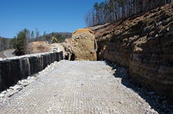
The Missouri Department of Transportation (MODOT) had its engineers redesign the road section-known as Route 17 Over Jacks Fork River-to make it safer. To stabilize the soil along Route 17’s steep slope embankments, MODOT used gabion wall structures from Modular Gabion Systems, a division of C.E. Shepherd LP, based in Houston, TX.
The project required 673 cubic yards of gabion gravity walls. These massive structures were strong enough that no soil reinforcement was needed. They were used near the bridge over the river.
The project also required 49,010 square feet of mechanically stabilized earth (MSE) gabion walls. MSE walls have three components: facing element, soil reinforcement, and backfill.
On the Route 17 project the facing element consisted of galvanized welded wire mesh gabions measuring 3 feet wide by 3 feet high. They were stepped back 6 inches at every 3-foot-high course.
The soil reinforcement element consisted of welded wire mesh 3 inches by 3 inches, galvanized and PVC-coated, supplied in long rolls measuring 6 feet wide by 150 feet long. Welded wire mesh gabions are as flexible and permeable as twisted mesh gabions but offer greater strength. The fuse-bonded coating technology used for gabions from Modular Gabion Systems makes them more resistant to corrosion than is regular twisted or woven mesh.
The soil backfill element was excavated locally, placed in layers, and compacted properly. Together, the three elements created the required stable embankment.
Work on the Route 17 project started in early 2006. The contractor for the job was H.R. Quadri Construction of Van Buren, MO. Robert Sullivan was construction superintendent on the project.
“The area was really steep and confined,” Sullivan recalls. The biggest challenge was that “the existing terrain was so steep. Even clearing it to excavate for where the gabions would go was a bigger task than putting in the gabions themselves.”
Sullivan says the gabions averaged about 21 feet tall, though some were as high as 30 feet. In some places they were installed on top of three vertical rock shelves, each of which was 20 feet high. Some other gabions were placed on top of one or two rock shelves.
“I’ve never seen larger ones on Missouri projects,” Sullivan notes. “The most difficult ones to install were on top of the rock benches. We built the walls mostly from behind, building as we went up.”
The road project lasted through a range of Missouri weather, from cold through hot, humid summer, but weather didn’t really affect the work. It was completed in the late summer of 2006.
“We kept traffic going the entire time,” Sullivan says. “Obviously we stopped for shooting rock, then let one lane of traffic go while we cleared up excavated rock. It was difficult, to say the least.”
George Ragazzo, general manager of Modular Gabion Systems, provided the onsite gabion installation assistance to Quadri Construction.
Lake Belle View
Residents of Belleville, WI, had been dreaming of restoring the local 94-acre Lake Belle View for more than 30 years. Their lake had gradually filled up with so much sediment and agricultural contamination that it was less than 2 feet deep in most areas.
Because funds were limited, the townspeople weren’t sure exactly how the lake restoration should be done. State and federal environmental regulations had tightened over the years, complicating matters.
One thing was certain: The project had to include a way to keep Lake Belle View separated from the nearby Sugar River. The best solution was to construct a 3,200-foot-long berm. Constructing the berm on part of the lakebed turned out to be the most cost-effective approach. But that lakebed was composed of soft lake sediments, certainly not the most stable of soils.
Montgomery Associates, the engineer for the project, and Belleville officials considered excavating the lake sediments and replacing them. However, the varying depth of the sediments made costs unpredictable. Doing so would have also required a larger construction area, with more negative impact on the environment.
The engineers decided that the berm would remain stable on the silty lakebed if they added a mechanically stabilized layer (MSL) first. This MSL would create a firm, unyielding base upon which to build up the berm to about 5 feet high. They reached this decision after extensive soil testing and consultations with geotechnical engineers. Using the MSL saved the town of Belleville about $250,000.
The engineers chose to use Tensar TriAx Geogrid to stabilize the MSL at the base of the berm. TriAx Geogrid is composed of triangles connected in a hexagonal pattern. This geometry makes TriAx interact more effectively with the aggregate layer, explains Jim Howley, P.E., senior north central regional manager for Tensar International Corp.
“The open apertures of the grid change the properties of the aggregate layers above,” he says. In effect, the TriAx Geogrid “enhanced the structural capability of the aggregate layers above it.”
In this project, “the use of the geogrid added a separation layer and contributed stability. Otherwise, we would have had to add more material or make a larger construction area, and we had permit limits [to comply with],” Howley says. “You’re always trying to minimize the environmental footprint.”
Tensar’s TriAx Geogrid product line has several types of geogrid to suit different types of projects. The geogrid used in this case is at the higher end of the performance line, Howley notes. The rolls of TriAx Geogrid measured 13.1 feet wide by 246 feet long. They were overlapped by 3 feet at their ends and secured with nylon cable ties. Then the geogrid was covered with 30 inches of well-graded sand.
Howley says some customers are surprised that with the use of TriAx Geogrid a fabric separator layer is rarely, if ever, needed. That’s because the geogrid’s apertures confine the fill and form a separation barrier, as they did in this project between the sand fill for the berm and the existing lake silt. As the apertures confine the sand fill, natural filtration is enhanced, allowing water through, but not silt particulates.
He notes that the most challenging part of the Lake Belle View restoration was “the constructability of the project. When you drive construction equipment over unstable soils, it’s a delicate undertaking.”
To do that safely, “a lot of upfront work had to be done, including a lot of geotechnical testing. This prework made the project more complex,” he says, “but it also made getting approval from the [Wisconsin] Department of Natural Resources easier. The geogrid facilitated the approval process because [with it] we created a smaller environmental footprint.”
The restoration of Lake Belle View began in the fall and continued all winter. The project was finished in 2010. The cost of $2.3 million was paid by Belleville residents, donors, Dane County, the Wisconsin Department of Natural Resources, and other partners.
“We built the berm before the freeze, and the berm became the access road for dredging the lake,” Howley says.
The residents of Belleville have their lake back for swimming and fishing. The berm remains stable, keeping river sediment away from the lake’s clear waters. Atop the berm is a 10-foot-wide walking and biking path that residents enjoy using.
Four projects-highway redesign, lake restoration, shoreline stabilization, marina and habitat protection-show the range of permanent erosion control structures. They also demonstrate the importance of exploring options and choosing the one best for that particular project.


