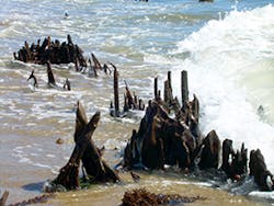
A steady wind sifts the finest grains of sand and blows them along with a briny spray toward a bank of dunes squeezed between a brackish pond and the ocean surf.
It’s one of the places Chris Maio has explored for traces of pre-colonial settlements in Massachusetts. Maio, a coastal geologist and educator, and now a Ph.D. candidate in environmental science, says the area just to the east of where we’re standing may have been home to a hunter-gatherer society of the southern Massachusetts Cape Cod coast hundreds of years ago. But it would be hard to spot any trace of that society today, because the forest where they would have lived is under the sea.
Maio suggests it’s easy to check it out for myself-just walk out a few yards, and I’ll see evidence of the forgotten forest. I wade into the surf and find a weathered tree stump about a foot in diameter. I test it with a firm shove to confirm the roots are lodged firmly in the place the tree once stood-a semi-petrified cypress forest holding, perhaps, a secret key to how quickly things can change on the coastline.
Maio says this section of coastal forest had been experiencing episodes of inundation starting about 1,200 years ago. According to carbon-14 analysis of the tree stumps found here, a big change came about 400 years ago, an event that flooded the once-thriving forest in a saltwater bath from which it would never recover. Today, the only hint to most passersby that there was ever dry land on this spot is a signpost warning beachgoers of potential hazards of tree stumps under the crests of the breakers.
“There is an even bigger forest out there,” he says, looking across the waves in the direction of Martha’s Vineyard. I see nothing but water. Today it’s called the Nantucket Sound. Maio, who is pursuing his doctorate at Woods Hole Oceanographic Institution, says the final inundation may have happened slowly over decades, or it may have happened swiftly in the course of a single big storm. But somewhere along the way, the sea overwashed any barrier islands that may have protected the coast and submerged the cypress forest, reshaping the coastline.
In the course of his work, Maio has also found artifacts of other times when sea level rise has threatened historical records.
Sea and Climate Pose Community Challenges
Sea levels and coastlines are always changing. Intuitively, we know coastal contours change imperceptibly with each breeze, carrying the finer grains of sand landward toward the dunes; each wave might drop a few grains on the beach, while pulling coarser grains toward deeper water, shaping a trough here, a bar there. The surf might gradually cut fresh meandering channels to carry the force of the next storm’s waves landward, carving out new contours for the shoreline. Beach migration, experts say, is an ongoing natural and normal process, yet society invests a great deal of effort into holding coastlines firm. However, as the climate warms and sea levels continue to rise, holding the line may become increasingly difficult.
So what are coastal communities to do?
It certainly seems reasonable that individual property owners want to protect their homes and businesses from rising waters, regardless of the cause. The difficulty is finding solutions that are palatable to the community and that have a chance of success. Moreover, many experts say that because of the complexities of the coastal engineering environment, it is very difficult to predict what the individual outcomes will be.
One ongoing debate is whether beachfront properties can in fact be protected without causing damage in the process, to the beach itself. For instance, for barrier islands, sea level rise (SLR) would predict the landward advance of sandy beaches and the ultimate migration of the shoreline inland. On an undeveloped beach, the erosion process would be considered a natural and environmentally desirable process, through which the sand rolls over on itself like the treads on a tractor as the beach gradually retreats. Scientists say, however, that on developed beaches protected by hard structures that act as barricades walling out the sea, the sand conveyor belt can be disrupted, interfering with the normal circulation of sand that creates the gently sloping shorelines that sustain beach ecosystems and that vacationers find so attractive.
Melissa Pringle, a consultant with Eco-systems Inc. in Jackson, MS, works with communities on the Gulf Coast to increase resilience to sea level rise and other climate-related coastal changes. “You do see where you harden the shore it actually disrupts the natural littoral drift of the sand,” she says.
“When you have development of the shore, then you have the hardening of the shore. The very reason people come is for the beaches, and then you see the erosion of the beaches, so it is quite a conundrum people get into. This is something we’ve been fighting for years. That’s why I think some of the softer solutions are very viable options in some cases.”
Sand Versus Sandy
Billy Mack, vice president and co-owner of First Coastal Corp., says his company approaches solutions to coastal erosion on New York’s Long Island on a case-by-case basis, trying to craft solutions that are appropriate to the geomorphology of the site, that fit the needs of the customer, and that conform to permit requirements.
Mack has a bit of a historical perspective on the coastal erosion problems facing residents of Long Island. His firm has been providing beach management and erosion protection systems to residential and municipal customers in the Westhampton Beach area for more than 30 years. He says a number of residents he has been working with in the Village of Quogue have been facing serious beach erosion issues for years, and now face the prospect of sea level rise making the problem worse.
“We had been managing Quogue for over 25 years and had installed several dune projects, rebuilding the dunes with beach-compatible sand over the past 30 years, maybe eight times,” Mack says.
As the climate warms and sea levels continue to rise, holding the line on coastal erosion may become increasingly difficult.
When Hurricane Irene came through in 2011, some property owners “had lost 40 to 60 feet of dune, and some of the houses had water under them,” he says. “Residents were frustrated that multiple sand dune restorations did not provide a predictable level of protection.”
Although sea walls may have done the job of protecting the property on the landward side, they are not allowed, Mack says, because of their unintended effects. It’s becoming more and more difficult for homeowners to obtain permits to install permanent, hard armoring structures of any kind, to prevent erosion anywhere along sandy beaches.
But the rules don’t stop the waves, and residents of Quogue desperately needed a new option to protect their homes.
Squaring Off With Mother Nature
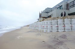
Mack decided to offer his customers a new approach to fighting erosion using a new, patented technology called Shorebag, also known as geo-sand cubes. Geo-sand cubes are 3-foot cubic geotextile sandbags made to be filled with about 1.25 tons of sand each. They can be stacked to the height required for protection and arranged to follow the contour of the property to be protected.
Over the winter of 2011, Mack had his crews dig a trench down to sea level on the seaward side of his clients’ properties to establish the foundation of the geo-sand cube wall. Next, they strapped the cubes together and filled them with beach-compatible sand to ultimately construct a multi-tiered wall of geotextile and sand, 13 feet tall with a horizontal footprint of 25 feet.
For episodic erosion, Mack says, the geo-sand cube wall is a good alternative to a rock wall. His firm can install a wall in as little as 24 hours after receiving notice, a rate he says is comparable to the time it might take to install a riprap revetment. However, in contrast to a rock revetment, the sand-filled cubes have the advantage that they can be removed just as quickly, if required, by simply slashing the bags open and letting either work crews or natural winds and surf redistribute the sand they contain.
Geo-sand cubes performed well when tested by Superstorm Sandy, which struck a nearly direct hit on the town. “The sand eroded away seaward of the wall, but the wall prevented overtopping,” Mack says. Homes in the area that lacked geo-sand cube protection suffered considerably greater damage. Mack notes that since Superstorm Sandy, “A lot of those homeowners are asking us to install cubes for their properties, too.”
Mack says First Coastal has installed Urban Environmental Corp.’s geo-sand cube shoreline protection systems ranging from as short as 100 feet in length up to several thousand feet, and he considers them “a good alternative to hard structures” for controlling the impact of waves.
Melanie McGillick, president of Urban Environmental Corp., which invented and patented the Shorebag, says that, used strategically, the cubes also bring an element of resilience to a coastal erosion protection practice. Constructed from multi-ply polypropylene, the bags are designed to be strapped together using Urban Environmental’s patented interconnection loops, giving the system a high degree of structural integrity. However, if an individual cube gets damaged or destroyed, McGillick says, it is easy to replace that individual module and tie a new bag into the system in its place. At the same time, Mack notes, the modular construction of the typical geo-sand cube wall allows it “to articulate” and dissipate some of the force and impact of the waves it encounters.
Breaking Tradition for Future Thinking
Facing up to sea level rise and the future of coastal erosion is not just about emergency responses to save lives and property; it also requires planning, and possibly even some new ways of thinking. A recent article by Ashton Berry, Shireen Fahey, and Noel Meyers, published in the Journal of Coastal Research, suggests that in many instances, coastal management strategists have been viewing coastal erosion problems-particularly the erosion of sandy beaches-through too narrow a lens. With their traditional laser-like focus on holding the coastline firm, they have been missing potential opportunities to promote coastal resilience.
The authors say that historically, the key defense against sea level rise has been to armor the coastline by various means to try to prevent change indefinitely. But they maintain the more holistic approach that from a management perspective, it might be better to think of the beach as a part of the process of an evolving coastline. According to the article, perpetual change might be one of the most important features of a healthy coastline, and in fact a beach’s ability to shift with the waves and wind is what allows it to survive.
The article describes this concept: “A function of sandy beach ecosystems (SBEs) is exemplified by trophic interactions and the succession of dune plants, whereas the diversity and density of species and the size and shape of sand grains typify their structure. The various structures and functions of SBEs enable their landward retreat over time in response to sea level rise (SLR). The ability to retreat is a crucial component contributing to the adaptive capacity of SBEs, their ecological resilience to SLR, and their ability to persist.”
Although preventing the retreat of sandy beach ecosystems has been the default adaptation to sea level rise everywhere, from the Rhine Delta in Europe to the Mississippi River in the US, the chances of holding the line indefinitely, while still maintaining ecological function, are not good.
Although engineered adaptation options such as revetment walls are common, according to the article, “they carry unintended consequences for coastal ecosystems, particularly for SBEs.” A loss of local habitat, when squeezed between “˜”˜fortifications” and rising sea levels, reduces the ecological resilience of SBEs to rising sea levels.
The authors propose taking a new view of sandy beach ecosystems that mirrors the four-dimensional viewpoint J.V. Ward, a leading stream ecologist and professor of biology at Colorado State University, envisioned for riverine ecosystems in 1989 in a paper entitled “The Four Dimensional Nature of Lotic Ecosystems,” published in the Journal of the North American Benthological Society.
In Ward’s four-dimensional conception of river systems, he maintains, “the longitudinal dimension integrates upstream/downstream linkages. Exchanges of matter and energy between the channel and the riparian/floodplain system occur along the lateral dimension. The vertical dimension, which has a lateral hypogean [underground] component, incorporates interactions between the channel and contiguous groundwaters. The fourth dimension, time, superimposes a temporal hierarchy on the three spatial dimensions.”
Just as Ward introduced new thinking for rivers, Berry, Fahey, and Meyers hope to achieve the same for beaches. They suggest that a perspective of beach ecology extended across four dimensions would lead to a better understanding of the major physical and biological processes that sustain the beach landscape function. They explain these dimensions as 1) the flow of sand along a beach via longshore transport corresponding to the longitudinal dimension; 2) the transverse exchange of materials between the nearshore, intertidal, and backshore areas of sandy beach ecosystems; 3) the interaction between sand grains and the spaces between them-benthic infauna and groundwater tables, they say, characterize the vertical dimension of SBEs. Finally, the fourth dimension represents temporal concepts, such as the time required for ecosystems to respond to disturbance and the time needed by beaches to rebuild following an erosion event.
Berry, Fahey, and Meyers recommend that in regions of the world where intense coastal development has yet to get under way, coastal managers carefully consider beaches as a dynamic system, taking into account all four of these dimensions when planning coastal land management activities.
Nonetheless, they concede that coastal managers are often called upon to produce quick results to deal with emergencies such as storm surge and acknowledge that sometimes out of necessity, they turn to the most expedient solutions available-for instance, protecting assets subject to wave action with coastal armoring, or implementing beach nourishment projects to keep popular tourist attractions looking good for vacationers. However, the authors argue that there are a host of less-often-used alternatives that, if used ahead of development, could enhance beach ecosystems and still allow for tourism or other social and economic activities. These include ecosystem conservation, setback provisions for development, “managed realignment of hard-engineered structures” to enable the retreat of beach ecosystems, and ecological engineering to improve the habitat potential of hard and soft adaptation options. Furthermore, they write that adaptation options need not be viewed in isolation or as the ultimate solutions to coastal erosion: “Instead, adaptation strategies must use long-term perspectives and consider a range of adaptation options used in combination or as staged approaches.”
Strong Community, Strong Beach
The questions are complex, and Melissa Pringle says that in planning for sea level rise and preparing for coastal threats, good science is essential. Although she feels it is important to preserve the ecological function of the shoreline, she cautions that on coastlines where tourism is a major engine of the economy, achieving resilience will require searching for solutions that can be “successful in reducing erosion while still allowing recreation and the natural shoreline processes.”
That’s a tough needle to thread, but Pringle believes the Mississippi coastline is looking ever more resilient with time. In the years since devastating losses on the Mississippi coast from hurricane Katrina, Pringle says, “There has been a great deal of change. We’re trying to implement coastal resilience practices to plan for sustainable growth, and also promote alternative shoreline protection practices such as living shorelines.”
Although she says living shorelines can offer a viable alternative to hard armoring, they may not be the appropriate fix for erosion for every circumstance. “You have to look at the site characteristics and conditions before using a living shoreline.” In some cases, she says, communities might opt for “a hybrid of some harder structures and plantings in combination that might help on the erosion issue and be aesthetically pleasing as well.”
Pringle, the senior principal scientist and vice president of Eco-Systems Inc., an environmental consulting firm based in Jackson, MS, says careful planning and sound science are the best bet for withstanding the worst potential effects of sea level rise and coastal threats, and that effort should be a community priority. She says planning for coastal resilience requires not only understanding the ecology of the beach environment, but also understanding the economic, social, and political landscape of the communities that depend on the coastal environment. Eco-Systems’ team of scientists, planners, engineers, and landscape architects recently helped compile the Smart Growth Toolbox for Coastal Mississippi and the Clean and Resilient Marina Initiative Guide for delivery to the Gulf of Mexico Alliance (GOMA). Both of these documents illuminate techniques and policies that she says can help coastal communities enhance their resilience to sea level rise and coastal hazards by encouraging smarter practices.
The Toolbox promotes the idea of building within smaller footprints and directing development toward infill sites to avoid disturbance to more pristine environments. It also encourages the use of “green technology” and ecologically resilient infrastructure, such as living shorelines.
Pringle is also a member of the Coastal Community Resilience Team of GOMA, a multistate partnership between Alabama, Florida, Louisiana, Mississippi, and Texas, whose goals are to “increase regional cooperation on the ecological and economic health of the Gulf.” She says the entire region is “seeing a big push to move toward softer, living structures for coastal protection and better use of design.”
According to Pringle, GOMA itself has been promoting living shoreline workshops across the Gulf of Mexico states, teaching participants the techniques, the policy, and the permitting requirements for implementing living shoreline practices. In addition, she says Mississippi has now adopted a “living shoreline general permit” under the US Army Corps of Engineers and the Mississippi Department of Marine Resources that can grant living shoreline permits within 30 days of application for areas where they are appropriate. For shorelines that are not subject to intense waves, she says, “The living shorelines are a good option, and the general permit makes it a little bit easier and more user friendly for homeowners.”
Pringle says more than anything else, the solutions to sea level rise adaptation and hazard preparedness have to be economically feasible. For instance, while surveying marina managers for the Clean and Resilient Marina Guide, she noted marina owners showed a keen interest in making their marinas clean and resilient, “but the question is, what does that do to their bottom line? Because it is a business-so it has to make sense to them. We need to show cost savings, whether in their initial design and construction, or cost savings in the long-term maintenance of a more resilient marina, or cost savings associated with decreased destruction or property damage. If we can show them that it makes a difference on the bottom line, then it’s a home run.”
Pringle says she’s eager to see the clean and resilient principles in practice in a real-world scenario. “We’re hoping that maybe we can even find funding for someone to go through the process from the initial design to the construction to the maintenance.”
She adds, “You have a lot of development pressures on the coast; you have people flocking to the coast for the amenities such as the beach, the wetlands, and the estuaries, but there’s a fine line you have to walk because you don’t want to insult the natural resources to the point of no return. But it has to be a sustainable use-you have to enjoy it but also protect it and sustain it.”
She explains more about this delicate balance. “The Coastal Zone Management Act set it up the best: It has to be a balance between economic development and environmental protection. You’re not going to hold back the ocean, you’re not going to tamp the storms, and you’re not going to stop the people who want to live on the coast. It’s finding that sweet spot where everyone can live in harmony. Where you’ve got an economic boost-perhaps through eco-tourism, which can itself help provide conservation, because people want to do the alligator boating tours, they want to look at the birds in the wetlands, and they want to do the canoe trip or go to the beach.”
Exploring the Mystery of History
There have been some exciting changes on the New England coast for Maio, with this year’s severe winter storm season exposing six previously unknown paleoforest sites, some with undersea forest remnants dating back 10,000 years. He says historical perspective is as “central as science” for coping with sea level rise.
“You have to know what happened in the past to have a perspective on what happens in the future. Most people don’t have any idea that sea level has been rising for the past 10,000 years and that at some times it was rising much faster than it is today. But you need to know all these things to make a sound decision about how to react in the future, especially when it’s going to come to billions and billions of dollars of taxpayer money. It’s essential to have this understanding of what the coast has done in the past, and what’s the potential for change the future.” Nonetheless, he says, every situation is unique to a certain extent. “Some places are going to be just fine in the future. Other places are definitely under threat.”
Although it could take decades to implement, Maio believes “people are going to have to step back from the coast,” echoing the story that the artifacts tell of pre-colonial settlement of New England’s now-submerged cypress forests.
The shape of the coastline has been changing since the time of the earliest Americans up until the present, and it will change drastically in the future. Yet it is also possible that through thoughtful planning, and careful management, society might continue to enjoy what the shore has to offer, while building resilience into both communities and ecosystems.

According to the analysis, authored by Tracy Monegan Rice of Terwilliger Consulting Inc., Texas has the greatest extent of undeveloped sandy beaches, with only 14% of its 370 miles of barrier island beachfront developed. Of particular note, Texas’ potential habitat includes Padre Island National Seashore, representing “the longest undeveloped barrier island in the world with nearly 66 miles of preserved sandy, oceanfront beaches.”
The study, which relied upon data collated from several sources, including published reports such as the United States Geological Survey’s recently completed Coastal Classification Atlas and imagery from Google Earth, shows that Texas also has the largest areas of “least modified” beach habitat that could serve as ideal plover wintering ground. The study reports that in Texas, “long stretches of undeveloped barrier islands and peninsulas with overwash passes and flats, discontinuous dunes, and sparse vegetation are common.”
However, the report also notes that the Mississippi islands of the Gulf Islands National Seashore and the area of the Florida panhandle, which are protected by the Gulf Islands National Seashore, Eglin Air Force Base, and Tyndall Air Force Base, also provide similar habitat and present opportunities for better conservation efforts to avoid higher levels of modification and disturbance as sea level rises.
Small areas of the Atlantic coastline—in particular, Cape Lookout National Seashore and Cape Romain National Wildlife Reserve in North Carolina—also seem to have potential as future habitat for the wintering plovers as sea levels continue to rise. The study also cites possible habitat opportunities among undeveloped and preserved islands of Georgia, which provide “a uniquely contiguous suite of inlets and sandy beach habitats.”
FWS states, “All of these areas are well-suited to allow habitat migration with rising sea level, and indeed are already showing signs of doing so.”