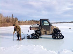
When Colin Barnard and his colleagues go to work, their gear may include a firearm for bear protection and a satellite phone for communications. Only recently was he able to get a 4G phone. Knowing survival skills and wilderness first aid is as essential as knowing how to mitigate environmental damage. Bernard is the GIS program administrator/conservation specialist for the Salcha-Delta Soil and Water Conservation District in Delta Junction, AK, which is tasked with reducing soil erosion and water-quality problems in a remote 3.7-million-acre region. Accessing technology and supplies isn’t as easy as calling a local dealer and having them in short order. “We are 100 miles from the nearest town, Fairbanks, which is about 390 miles from Anchorage, the nearest port,” Barnard points out. On a recent job installing a low-water crossing on military training grounds, shipping articulated concrete blocks would have cost more than the project’s funding. The team constructed the blocks onsite using a manufacturer-provided form. Though the region is remote, work abounds. The US Army uses nearly 1 million acres for training activities, including significant vehicle traffic and live-fire training. The conservation district is under contract with the Army for land rehabilitation and maintenance. “The military likes training here because it is remote, but it creates an erosion problem affecting downstream users,” notes Barnard, adding that it’s a prime area for salmon spawning and wildlife.
What He Does Day to Day
As the “data guy,” Barnard feeds information to the district’s two engineers. Construction takes place during Alaska’s three-month summer; Barnard follows up with revegetation. Native seed is hard to come by. Barnard does his own cuttings for willows and creates his own native seed collection. During the winter, Barnard does planning and surveys, such as a recent Jarvis Creek ice survey to develop hydrologic models for a streambank stabilization project near Fort Greely, a US Army garrison. While his peers in other states can download tables from the US Geological Survey or Natural Resources Conservation Service websites, Barnard develops his own, collecting data to develop models to predict hydrology and deal with soil erosion in what is essentially virgin territory. Bernard is dispatching a team across the Delta River to a remote location to do a soil survey on military land that is being developed for training but lacks information on soil erosion problems. He’s also doing topographic and flow surveys to study glacier effects on the Jarvis Creek watershed’s hydrology, stream movement, and streambanks.
What Led Him to This Work
Barnard, whose father was in the US Air Force, was born in Texas and traveled throughout the world. A soil lecture at the University of Alaska in Fairbanks led Barnard to conclude that soil “is the breadbasket of life.” He earned a B.S. degree in natural resources management: plant, animal, and soil sciences with a rural development emphasis. A subsequent job entailed working with the NRCS in American Samoa in steep-slope agriculture with farmers dealing with 40% slopes. Using what was available on the island to reduce soil erosion set the stage for dealing with his present challenges. The US Department of Agriculture transferred him to Delta Junction, AK, to work as a soil conservationist before he took his current job.
What He Enjoys Most
“In Alaska, being outside is an amazing experience,” says Barnard, adding that working outdoors is his job’s most enjoyable aspect. He also enjoys restoring damaged areas to “some semblance of pristine and still have the uses that we all enjoy or need.”


