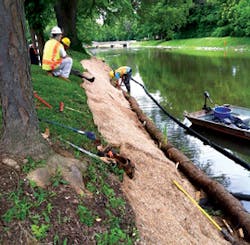
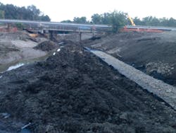
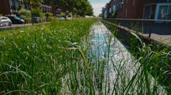
A lengthy stretch of creek in the Dallas-Ft. Worth area had suffered significant erosion damage over the course of many years. In addition, because this creek is in a low-lying area, at the bottom of a valley, it was prone to repeated flooding.
“To make matters worse, parking lots are positioned on either side of the creek,” says Shawn Perronne, general manager of Texas-based Builder Services, a woman-owned minority business. “But since these parking lots were downslope, the shear erosion would send sedimentation up to 4 or 5 feet deep into these parking lots. So the decision was made to come in and redo the whole area to better receive the velocity and prevent erosion.”
Part of the work involved both widening and deepening the channel. “We had to clean up the natural contour to facilitate a specific slope angle, per the drawings,” he notes.
The plan was to line gabions along the slope of the creek, across the bed of the creek, then up the slope on the other side. But a surprise was in store for Perronne shortly after the project began.
A coffer dam helped crews access the creek bed.
Water velocity testing had been performed prior to the bidding of the project, but at the time of this testing, water treatment plants adjacent to the creek had not been releasing water into the stream.
“So the result was that we had these variables that showed pretty much a standard, stagnant velocity of water through there,” explains Perronne. “But once we were in and began to install a coffer dam to allow us to do our work, there was a rain event, and that rain event also coincided with the municipalities’ dumping their refuse water into the creek. This resulted in a high water velocity in the area where we were working.
“We had to keep the area pumped, while still trying to excavate for the gabion mattresses and the gabion basket toe wall within the creek itself. Part of the technical difficulty was installing enough of the gabions, anticipating this strengthened water velocity, so that it doesn’t destroy previously installed work.
“We had to get down to the bottom of the creek to put in the toe wall. We had to stabilize that muck. We literally had to get down into the mud, install the toe wall, and then put the first part of the wall at the bottom of the creek,” he says.
“So there’s the toe wall, there’s the creek bottom, then there’s the slope protection, and then the cap protection, and then it toe-walls back in at the top of the slope. There is also a layer of geotextile filter fabric, a 4-ounce nonwoven filter fabric that is between the ground and the gabion baskets.”
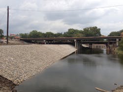
Perronne estimates that 1,500 linear feet of streambank was stabilized, using gabions supplied by C.E. Shepherd Company. Perronne chose the Shepherd gabions for this project because of his long history using the products without difficulty and without complications.
The coffer dam that was installed on the site was an earthen berm, reinforced with concrete beams, with a zone pump in place. But another issue had to be addressed as well.
“It turns out that there are endangered species here,” Perronne says. “There are fish that spawn upstream during a certain time in the spring. To avoid interrupting that, they created a subsidiary creek. So not only are they pumping the water from the main creek, they also excavated another channel where the fish can still migrate upstream around the coffer dam. This auxiliary channel extended for several hundred feet.”
The rocks that were used to fill the gabion baskets and mattresses were of a specific density and size, and came from a quarry nearly 100 miles away. Perronne notes that this particular rock was very highly sought after.
“Our requirement was for seven or eight truckloads a day to maintain our production as it was proposed and bid. But they could supply us with only two trucks a day. That was a constant battle, trying to get more rock.”
Perronne adds that most of the gabions are going to be underwater the majority of the time, so there is no intention of actively vegetating the gabion mattresses and baskets. “However, vegetative growth in the creek will occur naturally,” he says. “It may not be manicured vegetation, but it will definitely be revegetated naturally.”
Keeping the Ocean at Bay
Located in northeast Florida, 18 miles from Jacksonville, Ponte Vedra Beach is an upper-income resort community. It is home to great schools and great golf courses.
It is also home to frightening beach erosion.
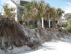
“It has made national news,” says Jim Kanuch of Crane Materials -International (CMI). “There is so much beach that just disappeared, out of nowhere. I was down there when this was happening. The homeowners were coming out, saying the beach used to go 20 feet farther out, and ‘It’s just all gone now!’ I think the majority of this happened just over a day or two. It just disappeared.”
Sometimes it’s even worse. Local papers report the loss of a hundred feet or more of sand dunes over short periods of time.
“It’s been happening for years in Ponte Vedra now,” says Buddy Kollar of Kollar Brothers Inc., a building contractor in Jacksonville. “You get what we call hot spots. There could be a northeast, southeast, or east wind. Then all of a sudden, you get an area that might be 400, 500, 600 feet long, or maybe even just 100 feet, but it just starts to erode back into the dune, back into the bank.
“The more it erodes, the deeper it gets. Then high tide comes, and there’s just no mercy. It doesn’t matter if there’s palmetto on top, the sand just starts sliding down. Heaven forbid if you get a wind out of the north or the south. The surf takes the sand away, and then the toe—where the ocean meets the dune—is lower, and it’s relentless.
“When this happens, the state DEP [Department of Environmental Protection], the county, and the contractors go into panic mode. The owners are trying to protect the dune. You can get a permit, but you still have to have the last item taken care of, which is a Notice to Proceed. Every ‘i’ can be dotted, every ‘t’ can be crossed in the permit, and they can say you’re approved, but until it is properly recorded at DEP in Tallahassee and every department has signed off and has this Notice to Proceed page, nothing can be done,” he says.
“You have to call the field rep from DEP. He comes out, and the surveyor or the contractor has the stakes in indicating where the wall is to be placed, according to what DEP approved. Only then can you get started. In the meantime, the ocean and the waves and the water don’t know to
slow down.”
The Dallas-area creek with gabions in place
He recalls a particularly critical job to protect the beach. “The worst scenario that ever happened was on the last five walls we did. It involved an older couple, 75 and 76 years old. The husband went down to take a look to see how bad it was on the ocean side. He tripped, fell and passed away.
“This erosion is only 11 feet from their house, with a 12-foot cliff, and she is now preparing for a funeral. She is now a widow, and she is watching this ocean come in. Turtle season is coming, and they tell us to stop working when turtle season comes, on May 1.”
The walls Kollar put up on this project use ShoreGuard 650 vinyl sheet piling from CMI. Approximately 14,000 square feet of material was used. “We put in 400 or 500 feet in six weeks. We were really under the gun with that one,” says Kollar. Work on the walls began in early 2014.
CMI’s Kanuch describes the ShoreGuard material used: “The product itself is one of our mid- to heavier-duty sheets. This was chosen because of the exposure height of the wall that they wanted to put in. It’s a rigid, vinyl material. You might think, ‘This is vinyl; I can bend this,’ but it’s really very heavy duty. When you touch it, you feel it, you realize that it is a lot stronger than you might have anticipated.
“The contractor created what we call a Navy-style wall. This involves putting pilings in front of the vinyl, and a waler across, perhaps three or four feet down from the top of the wall. This is a big beam that goes across the pilings. They tied anchor rods in through this waler and in through the vinyl, and tied it up to the deadman anchors that were placed in the homeowners’ backyards in order to stabilize the wall.”
Kollar, the contractor on the job, says he almost always uses vinyl sheet piling for these walls.
“We’ve done two wood walls, but I don’t even want to talk about them. It was a case of economics, but you end up working as hard or harder. The vinyl is just the way to go. You get it deep, you don’t need to have the filter material, and you can tie it back. We use a marine wall, which is piling, timber, and a helical.
“We’ve put in 53 of these in eight years in this area and haven’t lost a piece of cap, we haven’t had one push, and we haven’t had to go back and fill in behind the wall to where it settled. Why fight success? This baby just works.”
He adds, “I’ve used some other stuff—not on the ocean—where the manufacturing quality wasn’t as good. There would be friction between the sheets, and the next thing you know, you’re vibrating down the sheet that was already placed, and it’s coming up. But I’ve never had an issue with CMI, and I’ve used miles of this material in different locations.”
These vinyl sheets are attached, one to another, via a male-female type of connection. “We call it a tongue and a groove. We’ve learned which way to start these. We learned the hard way, to make sure that the tongue is going to receive the next sheet. One time, we were attaching to another wall, and we had the groove. It’s like the letter ‘C,’ and it fills with sand. When you’re trying to put the next sheet down with the groove going in, it won’t go because of the friction. It’s all tightened up, and there’s nowhere for that sand to go. So we have learned to make sure that the tongue is going to receive the next sheet, not the groove.”
Ponte Vedra before construction
When Kollar backfills these walls, the Department of Environmental Protection requires him to backfill with what is called beach-compatible sand. In some of these areas, it’s coquina shale, a natural shale that is sometimes mixed with mortar to create a strong building material.
“That’s what’s on the beaches here,” he says. “However, we’re not allowed to take it off the beach. You can’t take one bucket of that coquina to put it behind the wall. We have to import that.
“Inland, there are pits that have been dug in order to mine specific materials, and sometimes they’ll get into this coquina. If they are lucky enough to hit this coquina, they stockpile it. It becomes very expensive.
“They also want the color to match, they want the grain to match. You bring it out ahead of time, and there’s an inspection on it. You need to keep it there, and before it goes in, the DEP field rep comes by and has to verify that what you have is what he previously approved.”
The permitting process can be long and arduous.
“If you have an emergency, where a house is at peril, you can get the permit in about a month. If you can get your engineer and your surveyor together, everyone will hurry with this stuff. But the problem with the surveyor is that when an emergency comes up, the wind may be blowing 40 miles an hour, the rain is coming down, and they’re trying to set up their instruments. They have to get their technical data. They need to specify precisely where the dune is, where the toe is, and where the house is, and all that has to go to Tallahassee. I’ve had permits as fast as two and a half weeks, but when it’s just getting close and you’re not in dire straits, it could be four to six months to get a permit.
“There is a checklist, and you send all your information in, but there are a lot of departments that have to review this. It’s not just one department with one or two people. They may say that they need more data points, which are survey points, on the slope from the house to the wall. Or they may say they are unclear about the coastal conservation line to the septic tank. Then you’re back to calling the surveyor again and have to explain that you got a comment from DEP and you need him to come out so we can clarify that. But then the surveyor may respond that he has a number of jobs ahead of you now, so things get delayed even more.
“In the meantime, the homeowners are not sleeping. Every time a wave breaks, they’re looking outside. It’s a nerve-wracking process. You never know where it’s going to hit next. In the past eight years, it’s hit maybe eight different spots along a seven-mile corridor. We just call them hot spots.”
Although it can be difficult to predict where the next hot spot will be, Kollar has developed an admittedly unscientific procedure to identify at-risk areas.
“The surfers are the best way to figure out where these things may occur. If you watch where the surfers go, you’ll have an idea where the next hot spot may be.
“What happens is that sand bars begin building offshore, and in the channels between these sand bars, it creates a speeded-up flow of water, with power. The waves can only be as high as the water is deep. When the surfers congregate in an area, you can bet that’s the next place where there is going to be erosion. That’s what we’ve learned over the years.
“We’ll be putting a wall in, and surfers might be less than half a mile down the beach, and sure enough, two or three months later, that becomes a hot spot.”
Because of the potentially lengthy time required to obtain a permit and the Notice to Proceed, temporary walls have been used in the past to buy needed time for worried homeowners. But at least for the time being, local officials have notified contractors that temporary walls will not ordinarily be approved, perhaps out of concern for possible damage to the native turtle population.
Fortunately, however, the permanent walls are really meant to be permanent. “The vinyl will outlive us,” according to CMI’s Kanuch. “We pride ourselves with the ultraviolet light protection on these products, so that it doesn’t degrade.”
Kollar stresses the importance of using a reliable material and doing the job properly.
“DEP will tell you that you get one shot at armoring. If it fails, you don’t have an opportunity to go back in and say ‘I need another permit.’ You got one shot at this. They’ll tell you to pick your contractor carefully and make sure you get it all done right. This is permanent. It isn’t guesswork.”
Some time ago, his technique was put to a severe test.
“I was putting two walls in, here in Ponte Vedra. These were for old houses, and the pilings were only five feet deep; they used old telephone poles. We’re putting a wall in, and here comes a hurricane. It was about 30 or 40 miles off the coast, and this wall wasn’t backfilled yet. I had the helicals in, which are the tiebacks.
“These houses were side by side, and had old vinyl. They were mildewed and dingy. The ocean came up, and was breaking on these two walls. The spray was going into the air some 20 feet, some of it over the top of the houses. That 74- to 90-mile-an-hour wind was just pushing that water and that spray against the houses. I took as many pictures as I could, and got out of there. When I came back the next day, I didn’t know what I was going
to find.
“My walls were still straight as an arrow, in the ground where I put them. There wasn’t any erosion behind them, but the houses looked like they had been painted. They were pressure-washed from that ocean spray. They looked brand spanking new, from the ocean side. I knew right then that the work I was doing, the design that I had, was working. That’s what I’ve been doing ever since.”
For readers wondering why homeowners would build so close to the water, putting their homes at risk, Kollar noted that in many cases, these houses were built at a time when the sand dunes might have extended at least 200 or 300 feet beyond where they now hit the water.
Kanuch adds that in addition to the recent walls already constructed, an additional 10–20 homeowners in the same area are moving through the approval process to have walls built protecting their property. There is no governmental money subsidizing these walls, so they are all paid for by the homeowners themselves.
“If I could have DEP approve bulkheads straight down the line, I could put 50 in,” says Kollar. “They would all do it. But one qualifies, and another doesn’t. This one is close enough to the ocean, and is old enough, so it qualifies, while the next one is old enough, but far enough away that it doesn’t qualify.”
He adds, “It’s the 20-foot rule. This was put in place in the 1960s. The toe is at the bottom, where the dune hits the ocean, and the top of the dune would be the angle up in your yard. When the bottom, not the top, of the dune is 20 feet from your foundation, you qualify to apply for armoring to protect your property.
“This is why people get depressed, why they go to the doctor. They watch 200 feet of dune wash away, and now it’s right up to their house.”
At least the homeowners with Kollar’s walls can feel safe.
Beautifying a 19th Century Canal
The Indiana Central Canal, built in the 1830s, runs from Broad Ripple, an Indianapolis suburb, into downtown Indianapolis.
“It used to be for transportation. It runs adjacent to the White River, and it has been a municipal drinking water source since around the early 1920s,” says J. Eric Spangler of Hoosier Aquatic Management. “It has 1:1 side slopes, and they historically have had turf grass and riprap, and a lot of money was being spent on maintenance. Now we’re going in and putting in native vegetation. We’ve stabilized the slope at the toe with the Vegetated Living Log, which is a coir fiber log. It has native plants embedded in it.
“So we’ve stabilized the toe with that, and then behind it, we’ve done a mixture of sedge meadow down on the lower end of the slope, and a wet mesic mix on the upper end of the slope. These seeds on the slope were covered with a straw-coconut erosion control blanket. This addressed about a six-and-a-half-foot distance from the log up the slope.”
Construction began in May 2014 and was completed by November, but it is anticipated that it will take about three years for the seeds to become mature plants. Approximately 700 linear feet were treated on each side of the canal.
The most unusual aspect of the project was the “hoop house” that covered these slopes after the Living Log, seeds, and erosion control blanket were set in place.
“It’s like a portable greenhouse,” says Spangler. “It runs the entire 700-foot length section that we treated, along both banks of the canal. We’ve put goose netting over the top of the hoop house. In late winter or early spring, we’ll put plastic over it to speed up the growing process.
“There are a lot of ducks and geese in the area. To ensure that they wouldn’t pull out and eat any of the material we put down, the hoop house was put in place. But by the middle of 2015, it will come down. We won’t need it at that point.”
He notes a number of challenges he had to contend with on the job.
“There is an adjacent trail that we didn’t want to shut down, so we couldn’t bring in any heavy equipment to treat the canal slopes. That runs up the cost, and you have to put in another pathway for people to get around, because that would tear up the trail that is there.
“In addition, from an environmental standpoint, because the canal is one of the drinking water sources for the city of Indianapolis, we weren’t allowed to use any heavy equipment unless it had special hydraulic fluids that are nontoxic. This was the best non-invasive method we could come up with.
“We also had to erect turbidity barriers. And we were allowed to work on only 100 linear feet at a time. So we would set up the turbidity barrier around this section. When we finished that section, we would move the turbidity barrier down to the next 100-foot section.”
The project attracted a great deal of attention, though. “It’s such a high -profile project, we had people stopping by, asking what we were doing. It seemed like every 10 minutes this would happen.”
