Brays Bayou master plan: Engineering urban resilience
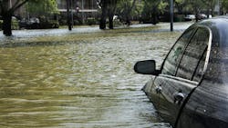
As one of the most flood-prone cities in the United States, Houston knows the stakes of inadequate stormwater infrastructure. In response to increasing climate volatility, aging drainage systems, and rapid urban growth, the City of Houston commissioned a city-wide Stormwater Master Plan. Part of this effort included the Brays Bayou Watershed which was led by LAN. The Master Plan and Model is a forward-looking project designed to transform how the city prepares for and mitigates flood risk.
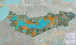
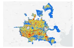
Spanning approximately 128 square miles, the Brays Bayou watershed includes more than 1,000 miles of storm sewer within the city limits and encompasses some of Houston's most critical infrastructure, including the Texas Medical Center, NRG Stadium and the University of Houston. Developed by Lockwood, Andrews & Newnam, Inc. (LAN), the Brays Bayou Master Model Drainage Plan provides a new foundation for stormwater management in a complex, densely urbanized environment.
Beyond conventional flood planning
The Brays Bayou plan is the first in the city to integrate both components—channel systems and local storm sewer networks—into a single, comprehensive model using advanced 1D/2D InfoWorks ICM modeling.
"This watershed contains approximately 40% of the city’s stormwater infrastructure, and with so much at stake, our modeling needed to go further than any plan before it," said Matt Manges, PE, CFM, ENV SP, project manager for the Brays Bayou Master Model at LAN. "We delivered a model that not only reflects current conditions with unprecedented accuracy but also provides actionable data for decades to come."
The scale and complexity of the model were extraordinary. The LAN team subdivided the watershed into seven interconnected models to maintain manageability and reduce computation time. In total, the models included:
- Over 13,900 individual storm sewer pipe segments;
- More than 15,000 nodes, including manholes, inlets, and outfalls;
- Greater than 3.5 million mesh elements to capture detailed overland flow; and
- Over 400 sub-basin and watershed overflow points.
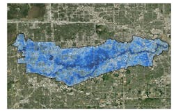
These simulations covered seven return-period storms (from 2-year to 500-year events) and three historical storms, including Hurricane Harvey. Each scenario was used to assess existing infrastructure, identify capacity constraints and visualize overland flow interactions between storm drains and the Harris County Flood Control District's open channels.
Challenges at scale
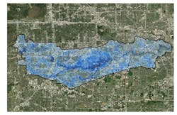
Modeling stormwater behavior across the highly urbanized Brays Bayou watershed presented technical challenges due to its infrastructure density and interconnectivity. To optimize performance and maintain precision, LAN divided the watershed into seven interconnected sub-models, enabling efficient computation while capturing detailed hydrologic behavior.
With multiple stakeholders and evolving project needs, LAN prioritized a flexible, collaborative approach—ensuring the model met both technical requirements and planning goals. Coordinating across agencies and internal teams helped align the work with Houston’s stormwater objectives and ensured the modeling outputs could be used for practical implementation.
Brays Bayou’s connectivity to adjacent watersheds, including Sims and Buffalo bayous, required careful coordination to account for inter-basin flow. Sharing boundary conditions and overflow data enhanced the accuracy of the regional model and marked a meaningful step toward integrated flood planning.
Effective project delivery also depended on robust coordination and task management. Through adaptive workflows and quality control measures, LAN maintained schedule integrity while delivering a technically sound foundation for long-term planning.
Defining risk with data
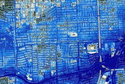
To help the City of Houston prioritize its capital investment in drainage projects, LAN developed a citywide Flood Damage Index (FDI) and Severity Ranking Tool. This tool evaluates multiple risk factors—including flood impacts to structures, population, mobility, and critical facilities such as hospitals and schools—and provides a scalable way to compare flood severity across the city.
The FDI tool was delivered as an interactive ArcGIS Python toolbox, making it accessible and adaptable for long-term municipal use. The tool allows city staff to adjust weightings of different metrics and re-run analyses as priorities shift or new data becomes available.
"What makes this tool so effective is its flexibility," said Luke Villanueva, PE, one of the project’s lead modelers. "The city can emphasize different priorities—such as mobility or population risk—and generate targeted rankings in minutes. That level of responsiveness changes how Houston can plan its stormwater investments."
The Brays Bayou modeling effort also provided the foundation for a broader Focus Area Identification effort led by LAN. These focus areas define high-priority zones for further study and prioritization, giving Houston a data-driven roadmap for resilience planning. The tool empowers the city to shift from reactive response to proactive planning, turning floodplain mapping into a blueprint for strategic action.
Balanced infrastructure investment
Beyond technical achievement, the Brays Bayou Stormwater Master Plan helps support balanced infrastructure investment. By using the FDI tool to assess flood vulnerability across all communities, the city can direct improvements where they are most needed—protecting both people and critical public assets.
"We wanted to provide the City of Houston with more than a model," said Manges. "We wanted to give them a way to visualize and act on flood risk with clarity and purpose. That includes protecting the most vulnerable residents and essential public assets."
The plan also lays the groundwork for future sustainable design. By identifying systemic issues in current drainage infrastructure, the city can plan and prioritize improvements that go beyond patchwork fixes and address root causes. Long-term, these improvements support Houston’s broader goals of climate adaptation, environmental stewardship, and community resilience.
Supporting capital improvement planning
With more than 34,000 structures located in the 100-year floodplain and more than 105,000 in the 500-year floodplain within the Brays Bayou watershed, this portion of Houston faces significant flood risk. The Brays Bayou Master Model provides a clear-eyed view of those risks, helping the city make informed decisions about which areas to study and where to develop projects to pursue future capital investment.
Although the current scope of LAN's involvement concluded in early 2024, the long-term implications of the project are just beginning to unfold. The City of Houston is expected to incorporate the model findings and focus area recommendations into future capital improvement planning, and the project website will eventually include interactive maps for public awareness and transparency.
Future phases could include engineering design for neighborhood drainage improvements, super neighborhood-scale projects, or channel modifications identified through the study. LAN and its subconsultant, 5engineering, are well-positioned to support implementation efforts as new funding becomes available.
The master plan also opens the door for grant funding opportunities. By presenting flood risk data in a consistent, quantitative format, the city can build stronger business cases for future projects.
A model for the nation
The Brays Bayou Stormwater Master Model is not just a milestone for Houston—it represents a national blueprint for how cities can integrate modern modeling, risk-based planning, and long-term vision into flood resilience.
"Flood risk is one of the most pressing infrastructure challenges facing American cities," said Manges. "This project shows how cities can use advanced modeling and flexible planning tools to make smarter, fairer investments that protect both people and property."
For engineers, planners, and policymakers nationwide, the Brays Bayou project offers a case study in scaling technical innovation to match real-world urban complexity. By combining technical rigor with adaptive planning tools, Houston now has a master plan that is as resilient and dynamic as the city it protects.
As more cities confront the effects of aging infrastructure, climate change, and rising urbanization, the Brays Bayou Master Model demonstrates what is possible when data, design, and equity converge in the service of public good.
About the Author
Matt Manges
Matt Manges, PE, CFM, ENV SP
Brooklynn Isom
Brooklynn Isom, PE, CFM
Luke Villanueva
Luke Villanueva, PE