What to know about Hurricane Melissa
Quick Facts
- Strength: Reached Category 5 intensity upon landfall in Jamaica
- Maximum sustained winds: Up to 185 mph
- Minimum central pressure: Dropped to around 892 millibars
- Path: Made landfall in southwestern Jamaica, then moved toward southeastern Cuba and the Bahamas
- Movement: Tracked slowly west-northwest at roughly 3-5 mph in initial phase
- Death toll: At least 30 people in Haiti, Jamaica and the Dominican Republic
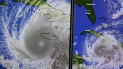
The Caribbean faced a major storm threat as Hurricane Melissa rapidly intensified into a Category 5 hurricane as it made landfall in Jamaica on October 28. The hurricane weakened to a Category 4 while exiting Jamaica and made landfall in Cuba on October 29 as a Category 3 storm. The hurricane is maintaining Category 2 wind speeds as it heads north through the Atlantic Ocean.
Key takeaways about Hurricane Melissa
-
Strength & path: Melissa struck Jamaica with sustained winds around 185 mph and a central pressure near 892 millibars, making it one of the most intense Atlantic hurricanes on record. After Jamaica, it is forecast to cross eastern Cuba, then pass near the southeastern Bahamas and possibly Bermuda.
-
Rainfall & flooding risk: Rainfall totals of 1–2 feet are possible across Jamaica’s interior, with isolated higher amounts up to 30–40 inches in mountainous terrain. Locally heavy rainfall poses severe flash-flooding and landslide risk.
-
Storm-water and infrastructure implications: For stormwater professionals, Melissa’s slow movement and heavy rainfall raise concerns about runoff management, drainage system capacity, erosion control, and storm-water pond overflow. Urban and rural watersheds may experience major stress, and backup systems or overflow conduits may be tested.
-
US impact potential: While the U.S. eastern seaboard currently appears unlikely to take a direct landfall, moisture from Melissa may feed into coastal rainfall events or surge conditions.
What it means for the stormwater industry
Large storm events tend to put stormwater infrastructure and management practices into the spotlight. Record storms stress the need for proper monitoring and maintenance of systems, including:
-
Assess pre-storm readiness for drainage assets and retention basins in southern and coastal jurisdictions.
-
Monitor forecasted rainfall and runoff volumes, especially where infrastructure is aging or capacity is marginal.
-
Stay aware of post-storm response needs such as sediment removal, culvert inspection and debris clean-up in watersheds prone to landslide or gutter blockage.
-
Review data and forecasting models for stormwater loading under extreme-rainfall scenarios—Melissa exemplifies how storm behaviour is evolving.
Stormwater professionals should continue to track forecast updates from the National Hurricane Center and national weather services, review vulnerability in their service areas and prepare both immediate and follow-up actions for storm-water system impacts.
About the Author

Alex Cossin
Associate Editor
Alex Cossin is the associate editor for Waterworld Magazine, Wastewater Digest and Stormwater Solutions, which compose the Endeavor Business Media Water Group. Cossin graduated from Kent State University in 2018 with a Bachelor of Science in Journalism. Cossin can be reached at [email protected].