Drone-based system delivers real-time moisture mapping for land and infrastructure management
A new drone-based imaging system will debut at the upcoming SPIE Future Sensing Technologies conference in Yokohama, Japan, offering real-time surface moisture mapping at up to 400 times finer detail than satellite-based methods.
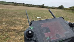
The Quantum Solutions Q.Fly Water system uses quantum-dot shortwave infrared (SWIR) technology to capture near-infrared and SWIR data simultaneously, calculating a Normalized Difference Moisture Index (NDMI) directly onboard the drone. Live, color-coded moisture maps are streamed to the DJI flight controller, allowing users to instantly visualize moisture distribution across land, crops and infrastructure.
“This system combines tuned quantum-dot SWIR sensors with onboard NDMI computation to deliver a live moisture view with centimetre precision,” said Alexander Bessonov, VP of products, imaging systems at Quantum Solutions, in a press release. “It means decisions can now be made in real time, right from the controller screen.”
The technology bridges the gap between low-resolution satellite imagery and point-based soil sensors, creating centimeter-level NDMI maps for uses such as precision agriculture, irrigation management, wetland monitoring and infrastructure inspection.
“Advances in quantum dot SWIR imaging technology, aerial robotics and on-edge computing are allowing us to reveal information that was previously invisible,” said Marat Lutfullin, CEO of Quantum Solutions, in a press release. “Our mission is to make that hidden data accessible and practical, turning high-performance imaging into an everyday tool for those managing critical infrastructure.”
Weighing about 600 grams, the payload integrates with DJI Matrice drones and operates through the standard DJI Pilot interface. Built on a proprietary quantum-dot imaging platform, it extends sensing capabilities beyond the visible spectrum for environmental and industrial monitoring.
