Woolpert to produce digital terrain model of Wyoming
Consulting firm Woolpert announced that it has been contracted by the University of Wyoming to produce a high-resolution digital terrain model and contours covering the entire land area of the state of Wyoming.
The Wyoming Geographic Information Science Center (WyGISC) at the University of Wyoming (UW) tasked Woolpert with producing the model. The project is supported by an appropriation made to the university by the State of Wyoming Legislature during its 2023 General Session.
To develop these products, Woolpert will use statewide topographic lidar data the firm collected through the 3D Elevation Program (3DEP) under a separate, ongoing, shared capacity contract for the U.S. Geological Survey (USGS).
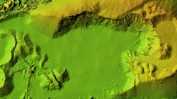
A digital terrain model is a datafile that produces digital modeling of surface terrain and incorporates break lines as needed for large bodies of water. Woolpert will use photogrammetric software to generate contours specific to the newly revised ASPRS Positional Accuracy Standards for Digital Geospatial Data.
Woolpert Program Director Brian Stevens said that the topographic contours will primarily be generated at 2-foot intervals except for areas with extreme elevation change, which may be generated at 10-foot intervals.
WyGISC is an interdisciplinary research and engagement center within UW’s School of Computing that supports state and local mapping and GIS needs through geospatial data and software development, and by connecting collaborators across the state to advanced research support within the university.
WyGISC Director Jeff Hamerlinck said the center is enthusiastic about partnering with Woolpert to build new capacity statewide in the use of lidar data and related products. He said plans are also underway for WyGISC to build a new lidar-specific component to its Wyoming Geospatial Hub and connecting it to UW’s Wyoming Innovation Partnership research data integration platform.
Stevens said these products will help advance WyGISC's research and application capabilities, as well as support future statewide mapping initiatives including the USGS 3D National Hydrography Program (3DHP). He expects the products to be delivered this summer.
“The digital terrain model will provide Wyoming with an up-to-date, highly detailed, and more comprehensive understanding of its land,” Stevens said. “From improving water drainage and floodplain mapping to assisting with preliminary engineering and design for agriculture, forestry, transportation, pipelines, water storage, or energy infrastructure projects, the model will serve as an invaluable resource for the Wyoming Geographic Information Science Center and other state agencies as they help move the state of Wyoming forward.”
This contract is now underway.