Hydraulic modeling approaches in drainage design and water resources engineering
Sept. 19, 2023
5 min read
In today's increasingly urbanized and environmentally conscious world, effective management of water resources has become more critical than ever. One essential aspect of managing these resources is hydraulic modeling, a process that facilitates the analysis, design and management of water systems in drainage design and water resources engineering.
This approach helps engineers better understand complex interactions between water and infrastructure, ensuring the optimal performance of drainage systems and reducing flood risks.
Developed by the U.S. Army Corps of Engineers, the Hydrologic Engineering Center - River Analysis System (HEC-RAS) has emerged as a popular and powerful software for open channel hydraulic modeling. HEC-RAS boasts a wide range of features and capabilities, including steady and unsteady flow simulations, sediment transport modeling and advanced two-dimensional (2D) capabilities. The software’s flexibility and robustness have made it an essential tool for engineers and researchers worldwide. To obtain accurate results, users must provide specific data inputs, such as topographic data, flow rates and channel geometry, among others.
Here we will look at a comprehensive overview of hydraulic modeling approaches in drainage design and water resources engineering using HEC-RAS. We will delve into the software’s key features and capabilities, exploring its applications in addressing common engineering problems, as well as examining its integration with Geographic Information Systems (GIS) and other advanced techniques. An in-depth look at hydraulic modeling using HEC-RAS can offer insights to those interested in leveraging this powerful software to address complex water management challenges.
Hydraulic modeling approaches
HEC-RAS plays a crucial role in drainage design by providing engineers with a comprehensive set of tools for simulating and analyzing various hydraulic scenarios. By modeling complex flow conditions and predicting potential problems, engineers can optimize their designs, ensuring proper functioning and resilience of drainage systems.
Common drainage design problems addressed using HEC-RAS include stormwater management, culvert and bridge design, and assessing floodplain, flood attenuation and riverine detention. HEC-RAS can analyze stormwater runoff and design conveyance systems, such as channels and culverts, to ensure adequate capacity and minimize the risk of flooding. The software can simulate various rainfall events, allowing engineers to evaluate the performance of their designs under different storm conditions. In culvert and bridge design, HEC-RAS enables engineers to model flow conditions and assess the performance of these structures. By simulating various flow scenarios, including subcritical and supercritical flow, engineers can optimize the design of these structures, ensuring that they provide adequate conveyance while minimizing the risk of erosion, scour and structural failure.
HEC-RAS also aids in designing detention and retention basins to control runoff and prevent flooding. The software can model the storage and release of water from these basins, helping engineers to determine the optimal size and configuration to meet specific design objectives, such as peak flow reduction or water quality improvement. HEC-RAS provides engineers with tools to analyze river systems, flooding and sediment transport. Its capabilities help engineers make informed decisions, ensuring the efficient management and protection of water resources.
Common water resources engineering problems addressed using HEC-RAS include floodplain mapping and analysis, river/ stream channel design and analysis, and sediment transport modeling. HEC-RAS helps in simulating and evaluating flood events to create effective floodplain maps, which guide decision- making processes and enable the development of effective flood risk management strategies.
In river/stream channel design and analysis, engineers can use HEC-RAS to analyze channel stability and design river/stream channels for optimal flow conditions. This ensures that channels provide adequate conveyance while minimizing the risk of erosion, sedimentation and flooding. Sediment transport modeling in HEC-RAS allows for the analysis of sediment movement within river systems, helping in the design and management of erosion and sediment control measures. Engineers can predict sediment deposition patterns and develop strategies to mitigate the negative impacts of sedimentation on water resources and infrastructure.Advanced project applications using HEC-RAS in Bexar County, Texas
The Old Fredericksburg Road Project in Bexar County, Texas, is an advanced project that utilizes HEC-RAS to develop drainage solutions. This project involves the construction of 1.7 miles of road and related drainage improvements.
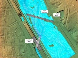
The purpose of this project is to address the existing drainage problem and detention pond along Old Fredericksburg Road (FIGURE 2). Two drainage improvement alternatives have been evaluated, and each alternative includes the addition of a bridge, culverts and excavation of channels to connect with the interstate conveyance system. Bexar County and the Texas Department of Transportation are evaluating alternatives that reduce flooding/ ponding and address maintenance issues.
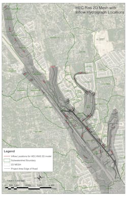
To analyze existing conditions and proposed alternatives, 2D hydraulic models developed using HEC-RAS have been created and run. These models utilize mesh sizes and break lines to represent topographic features such as the flow paths and
roads as shown (FIGURE 3). Furthermore, numerous culverts along the main road corridor have been modeled to effectively represent the backwater situation in this area.
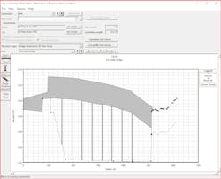
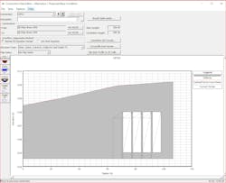
The proposed alternative solutions as shown (FIGURE 4, FIGURE 5, FIGURE 6) for improved drainage have been compared to the current drainage system with flows, water surface elevation, floodplain and velocity in terms of cost and effectiveness. This analysis allows for informed decision- making regarding the most efficient and cost-effective drainage solution for the Old Fredericksburg Road Project.
Overall, the use of HEC-RAS in this project demonstrates the advanced and complex drainage project applications
in Bexar County, Texas. By utilizing HEC-RAS 2D hydraulic model, the project team can assess the existing conditions, evaluate alternative solutions, and make informed decisions to improve drainage not just the culvert crossing along Old Fredericksburg Road.These advanced applications and techniques in HEC-RAS provide engineers with tools to address complex challenges in drainage design and water resources engineering. Hydraulic modeling plays a vital role in drainage design and water resources engineering, allowing professionals to analyze, design and manage water systems effectively. HEC-RAS is a powerful and widely used software that offers a range of features and capabilities for engineers to address various challenges they encounter in their projects and in these fields.
About the Author
Mason Liebau
Mason D. Liebau, PE, CFM, SIT, is principal, Water Resources (H&H) at Stantec. Liebau can be reached at [email protected].
Seoyoung Kim
Seoyoung Kim, Ph.D., PE, CFM, is water resources engineer at Stantec. Kim can be reached at [email protected].
Sign up for our eNewsletters
Get the latest news and updates


