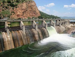
Bloede Dam Removal Uses Drones to Monitor Sediment Movement
On Sept. 5, the removal of the Bloede Dam from the Lower Patapsco River near Ilchester, Md., began. Researchers from the University of Maryland are using drone imagery to monitor sediment movement before, during and after the dam removal. The Maryland Department of Natural Resources, researchers from the University of Maryland and environmentalists supporting the removal hope that removing the 111-year-old dam will restore the valley’s natural habitat and that the drone assessment will better inform how scientists monitor rivers.
The dam was completed in 1907 and was operational for 30 years containing the first submerged hydroelectric plant in the U.S. Now, standing at 26.5 ft high, its removal will be one of the largest on the eastern seaboard. The dam has fallen under disrepair and blocks the migration of fish upstream, as reported by The Baltimore Sun.
“It’s just like a circulatory system that brings more health to the overall body that we call the Patapsco River, and the Chesapeake Bay,” said Ben Grumbles, secretary of the Maryland Department of the Environment and keynote speaker at the SWS Conference & Exhibition 2018.
The demolition of the dam began Sept. 5, following several delays in deconstruction due to heavy storms and flooding along the East Coast. Matthew Baker, professor at University of Maryland, along with collaborators from the Maryland Geological Survey, Maryland Department of Natural Resources, National Oceanic and Atmospheric Administration and U.S. Geological Survey are using drone technology to monitor sediment movement due to the dam removal. According to Baker, the dam stores approximately 2.6 million cu ft of stratified silt and sand less than 8 miles from Chesapeake Bay tidewater. Baker anticipates the sediment will redistribute downstream over a period of several years, based off of observing other dam removals.
“Our team is attempting to add to our measurement by deploying small, off the shelf drones that photograph the entire valley bottom,” Baker said in The Conversation. “Repeat photographs before, during and after removal can help us track the location of a sediment plume as it moves downstream. They also allow new perspectives of the river.”
By using overlapping photos before and after the dam removal, the team will create 3D computer models of the channel bottom and water depth to assess sediment movement downstream.
“If it works, this technology will likely change the way scientists collect measurement and monitor rivers,” Baker said.


