Addressing flooding in Texas’ most populous county
Harris County, Texas, which includes the Houston metro area, is the most populous county in Texas and the third most populous county in the United States. Western and northwestern Harris County are expected to experience a surge of land development activities soon because the local population, currently about 340,000, is expected to nearly double in the next 50 years.
This area drains into the two major reservoirs on the west side of Harris County, Addicks and Barker, which are designed to mitigate flooding in the downtown Houston area. The trend in land development will see many acres of prairie land and rice farms converted into a suburban environment, resulting in an increase in runoff volumes and peaks. Moreover, drainage in the area is complicated by the limited capacity in the Cypress Creek channel, resulting in overflows across the watershed divide during a five-year event. When storm events exceeding a five-year event occur in the upper northwest areas of the county, overflows from the Cypress Creek watershed sheet-flows into the Addicks reservoir watershed.
Notably, the section of Cypress Creek between US 290 and I-45 experienced severe flooding during the 2017 Hurricane Harvey rainfall event. The water levels in this section exceeded the 500-year annual chance event leading to a record number of flood losses. The area also experienced severe flooding during the 2016 Tax Day rainfall event. The repeated flooding in the area prompted the Harris County Flood Control District (HCFCD) to engage Michael Baker International and initiate an engineering investigation into feasible flood risk reduction solutions along Cypress Creek and its major tributaries.
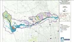
Twelve months later, Michael Baker delivered the Cypress Creek Watershed Major Tributaries Regional Drainage Plan Update to HCFCD. The goal of this work was to review and update recommendations made in a 2003 study, which had become outdated with the changes in topography, land use and rainfall standards. The revision identified additional feasible projects to reduce or eliminate existing flooding risks in the Cypress Creek watershed, with a project area spread across 135 square miles.
As part of this fast-paced project, Michael Baker studied 17 streams in the eight tributary watersheds to evaluate feasible flood mitigation alternatives and recommended mitigation plans that can be advanced to design. It also evaluated the effectiveness of large regional detention basins along 27 miles of Cypress Creek to reduce flood risk along the channel. Michael Baker’s tasks included revising hydrologic and hydraulic models to reflect updated existing and future conditions; developing drainage plans; performing an environmental assessment; and evaluating the feasibility of natural stable channel design (NSCD) for channel improvements and project management.
In addition to updating the 2003 plan, the project goals included:
- Evaluating potential flood mitigation benefits of expanding Cypress Park Stormwater
- Detention Basin at Norh Eldrige Parkway;
- Evaluating potential flood mitigation benefits of a stormwater detention site near Cypress Creek and Stuebner Airline Road; and
- Evaluating potential flood mitigation benefits of I-45 bridge expansion and improvement.
Modeling efforts
The Michael Baker team harnessed advances in modeling capabilities and more recent LiDAR and rainfall data to update the study for all Cypress Creek Tributary watersheds. The data review included evaluating and recommending updates to structural inventory database slab elevations based on comparisons to high water marks and historical flooded structure datasets. In addition, site visits were performed, as needed, to evaluate flooding areas and help formulate mitigation plans.
The team developed revised existing and future condition hydrologic and hydraulic models. Hydrologic model revision included reviewing and updating drainage areas based on 2018 LiDAR data; updating the effective HEC-HMS model for the Cypress Creek watershed to compute a revised existing condition; developing a future condition or full watershed urbanization condition based on projected development and growth patterns; and developing model runs for NOAA Atlas 14 rainfall data to evaluate the proposed mitigation plans. The hydraulic model revision included converting effective HEC-RAS hydraulic models to a newer version and updating geometry to reflect existing condition terrain and land use; adding new
structures or updating existing structures; developing 10-, 100-, and 500-year unsteady hydraulic model runs for 15 streams; developing a HEC-RAS 1D-2D model for a 27-mile section of Cypress Creek; developing a HEC-RAS 1D-2D model for Wunsche Gully and Senger Gully in the Lemm Gully tributary watershed to quantify and map the overflow from Wunsche Gully; and mapping the resulting floodplain boundaries, depth grid and Base Flood Elevations.
Evaluation of alternatives
After evaluating the feasibility and benefits of detention basins, the team determined that these stormwater best management practices (BMPs) would provide flood mitigation. The two detention basins with a combined area of 554 acres and storage capacity of 13,912 acre-feet reduced the water surface elevations on an average by 0.67 feet between I-45 and SH 249 along Cypress Creek and by about 0.3 feet between US 290 and SH 249. These positive results prompted a review of additional detention basins along Cypress Creek.
In coordination with HCFCD, 10 other potential detention basin sites were evaluated. The recommended alternative included nine proposed detention basins with a combined area of 1,152 acres, providing a capacity of 25,546 acre-feet, reducing the water surface elevations by 1.95 feet on average between I-45 and US 249, and completely removing 1,590 structures from the floodplain.
While these basins do not completely mitigate the 1% annual chance flood risk to insurable structures within the project limits, they do provide significant benefits. A cursory review indicated a need for an extra 30,000 acre-feet of storage, in addition to the proposed 26,546 acre-feet, to mitigate the flooding problems along Cypress Creek between US 290 and Hardy Toll Road.
Implementation plan
With the Cypress Creek Watershed Major Tributaries Regional Drainage Plan complete, HCFCD then proceeded with an implementation plan. Quiddity Engineering LLC (Quiddity) was selected by the Harris County Commissioners Court to develop the implementation plan. Michael Baker, as the H&H subconsultant to Quiddity for the implementation plan, developed additional hydrodynamic modeling to support a phased implementation plan for mitigation projects along the mainstem of Cypress Creek and its tributaries.
Projects were prioritized based on land acquisition, potential flood risk reduction and available funding. As of Spring 2024, preliminary engineering, design and construction is underway on multiple detention basins across the watershed.
As additional funding becomes available, new projects aimed at mitigating flooding in this rapidly expanding area will move forward.
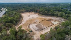
Construction will begin in 2024 on stormwater detention basins off T.C. Jester Boulevard and Cypresswood Drive — part of a series of basins coming to the watershed, including several in Cy-Fair.
About the Author
Mohamed Bagha
Mohamed Bagha, P.E., PMP, CFM, ENV SP, Regional Practice Lead – Water at Michael Baker International

