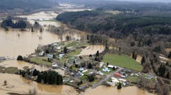
Thinking big on flood planning: What to learn from Texas' statewide approach
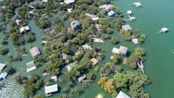
Weather extremes – destructive droughts and calamitous floods – have driven Texas to the forefront of planning for managing and taming water. Texas recently completed the first statewide flood plan in the United States, leveraging more than two decades of experience in water supply planning across its vastly diverse regions and learning more lessons along the way.
Thinking big and collaborating broadly, the river basin-based, bottom-up approach on flood planning is better preparing communities to reduce their risks to life and property. Beyond that, the effort has produced tools to improve floodplain management and policy recommendations that can guide state lawmakers. Just as important, the state flood plan will help set priorities for allocating billions of dollars of state and federal funds for local infrastructure investments — and incentivize essential future funding.
I. Background: Hurricane Harvey underscored the urgency of action as big as Texas
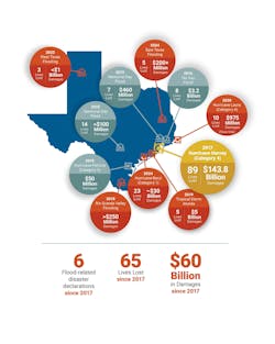
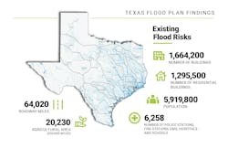
Even before Hurricane Harvey in 2017 caused $143 billion in property damage and resulted in 89 lives lost, Texas had experienced multiple serious flooding events due to increased rainfall amounts and intensity, climate variability, hurricanes and sea level rise. A state assessment in 2018 found that 20% of Texas’ population lived in areas at risk of flooding.
Reducing the hazards became a statewide priority, and the Legislature in 2019 directed the Texas Water Development Board to produce a state flood plan by Sept. 1, 2024. Lawmakers allocated $30 million for that process and created a new fund to help communities pay for projects ultimately included in the state plan.
Key lesson:
Leadership from the top is crucial to establish the framework and commit to funding, not just to start the planning but to follow through on implementing recommendations. But involvement at every level is essential to bring local needs and perspectives to the forefront.
II. Process: Regional flood plans forged coordination among divergent stakeholders
To create a bottom-up process, TWDB established 15 flood planning regions based on Texas’ major river basins. Each region’s plan was developed by a Regional Flood Planning Group (RFPG) that included voting members from 12 interest categories and non-voting members from state agencies. The individual RFPGs worked with a technical consultant (Freese and Nichols, Halff, HDR or AECOM) to build their plan with flood mitigation actions submitted by local cities/communities.
Collaboration and public outreach played key roles, especially with Texas’ diverse eco-regions and interest groups that spanned sometimes-contrasting combinations, such as rural/urban, desert/coastal, agriculture/industry, and environment/development. The watershed-based approach required that various entities within a planning group coordinate with their neighbors to make sure their projects wouldn’t harm others upstream or downstream.
Only projects included in the regional plans and recommended in the state plan are eligible for grants and low-cost loans through the dedicated fund.
Working on a compressed timeframe — including continuing through the COVID-19 pandemic — the groups held more than 550 meetings across the state and completed the plan on time. Each meeting was supported by the sponsor and the TWDB.
Key lesson:
Local and regional input and cooperation are vital for producing a long-range plan that meets the diverse needs of stakeholders while reducing risk and protecting public safety.
III. Data: Unprecedented level of complexity resulted in new assessment tools and insights.
TWDB generated the flood planning data hub as a starting point for all flood risk-related data resources for the regional flood planning groups, flood quilt for flood hazard data coverage and statewide cursory floodplain dataset. TWDB also generated technical guidelines for flood planning, including “no negative impact,” a geographic information system (GIS) database template for flood planning so the 15 regional flood plans can be brought together seamlessly as one state flood plan.
In each of the 15 regions, the technical consultants created data collection tools and websites for transparency and accessibility of information. Members of the flood planning groups could view documents and floodplain ordinances, submit comments and upload documents and videos.
Interactive maps allowed the public to point out flood events by “pin dropping,” and GIS-based tools streamlined the curation of public input.
The technical consultant teams compiled and processed an enormous amount of flood-related GIS data that included stormwater infrastructure, critical infrastructure, LiDAR, and flood hazard mapping. Data used for performing regional analyses then identified exposure and vulnerabilities to flooding as well as flood management and mitigation needs.
TWDB provided key datasets, including a “flood quilt” representing flood risk data that the consultants stitched together from a variety of sources and enhanced with local flood data. Some regions had detailed flood data while others did not even have regulatory FEMA maps. TWDB applied population data from the State Water Plan to create uniformity.
Key lesson:
Do not let an incomplete or imperfect dataset be a barrier to the planning process; use the best available and improve it as you go.
IV. Results
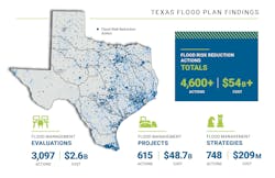
Flood risk reduction recommendations from the RFPGs included $54.5 billion in flood mitigation actions. TWDB compiled and ranked these recommendations into the State Flood Plan, which the public can easily navigate through an interactive web viewer. The flood risk reduction solutions are ranked in the state flood plan based on relative flood risk and flood risk reduction achieved by each proposed study, project or strategy. Cities and counties also can extract information from the state document for their future flood planning.
The process raised awareness about flood risk and defined areas of greatest need and gaps to address in the regions. It also centralized current flood management policies and standards to assist entities across the state and developed a resource of standardized rules and standards.
Key lesson:
A thorough and broad-ranging process can lead to secondary benefits, such as mitigation projects that would encompass nature-based solutions, enhance water supplies and create new recreational amenities. Applying the Social Vulnerability Index – a national measure of a community’s ability to recover from disasters – also helped elevate areas with some of the greatest needs but possibly the least resources.
V. Policy recommendations
Beyond creating a roadmap for infrastructure projects across the state, the flood plan yielded recommendations for legislative changes, policy revisions and floodplain management improvements.
Floodplain management recommendations included:
- Higher standards, such as freeboard, detention and no adverse impacts
- Incorporation of nature-based solutions for flood control
- Responsible asset management for flood infrastructure
Legislative and policy recommendations included:
- Providing consistent and enhanced flood funding at the state level
- Focusing on technical assistance for underserved communities
- Prioritizing flood safety at roadway stream crossings where most flood-related fatalities occur
Key lesson:
Like the adage says, an ounce of prevention is worth a pound of cure: It is not all about flood mitigation; preventing future problems with good policy can often be more impactful.
VI. Looking forward
Texas’ statewide approach already is having an impact as other states start similar flood planning programs. Oklahoma, for instance, has leaned on Texas for input and feedback.
These lessons can help guide other states in their flood planning:
- Collaboration and outreach are essential for understanding and buy-in.
- Funding — state and national — is fundamental to developing a plan and implementing its recommendations.
- Use the plan to drive policy improvements at the state and local levels.
About the Author
Reem Zoun
Reem Zoun, PE, CFM, ENV SP, Texas Water Development Board.
Scott Hubley
Scott Hubley, PE, CFM, Freese and Nichols, Inc.
Krista Bethune Melnar
Krista Bethune Melnar, PE, CFM, PMP, Freese and Nichols, Inc.
