Skip to main content
The stormwater and erosion control resource
Stormwater Management
Erosion Control
Green Infrastructure
Stormwater BMPs
Transportation & Construction
Sections
Stormwater Management
Erosion Control
Green Infrastructure
Stormwater BMPs
Transportation & Construction
What Is Series
Special
Videos
Podcast
Magazine
Quizzes
eHandbooks
White Papers
Webcasts
Stormwater University
Contact
About Us
Contact Us
Advertise
Awards
Subscribe
Affiliated Brands
WATERWORLD
WASTEWATER DIGEST
STORMWATER UNIVERSITY
STORMCON
ROADS & BRIDGES
Follow us on
https://www.facebook.com/stormwatersolutionsmagazine/
https://www.instagram.com/storm_water_solutions/
https://www.linkedin.com/company/19195026
https://twitter.com/estormwaternews?
Home
>
Back Issues
>
Erosion Control
>
January/February 2020
January/February 2020
January/February 2020
Digital
Edition
Archives
Erosion Control
The End of an Era but a New Beginning
Dec. 19, 2019
John Gallop/Getty Images
Erosion Control
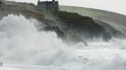
Q&A: Protecting Coastlines from Wind-Blown Waves
Dec. 19, 2019
Darryl Brooks/Dreamstime
Erosion Control
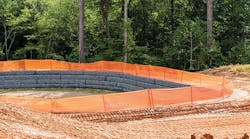
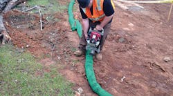
Guest Editorial: Viable Estimates and Good Shoes
Dec. 19, 2019
ALL PHOTOS: FILTREXX
Sediment Control
Keeping Down the Dust
Dec. 19, 2019
Robert Leeper, Haley & Aldrich, and UC Riverside
Erosion Control
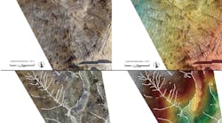
Eyes in the Sky
Dec. 19, 2019