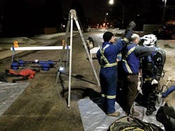
Pipe Project Stays on Track
Cues was contacted by an engineering firm and municipality to provide a solution for locating and modeling a concrete pipe 100 ft below the surface that was planned for relining.
The situation presented challenges due to the depth of the pipe and the inconsistent dimensions of the pipe shape. The only way to perform the reline was to dig a shaft down to the pipe to allow the installation of cured liners. To stay on schedule, the drill team needed to know the location at which to set the pilot hole, as well as the pipe shape at specific intervals to order the precast liners, before starting the shaft drilling.
The size and shape of the pipe varied slightly because it had been constructed by tunneling. A crew used jackhammers to open up the tunnel, then sealed the walls with wood ribs and concrete to form the pipe. In order to generate the location and dimensional model of the pipeline, a solution was developed that integrated location data with a 3-D LiDAR camera. The pipe was mapped using the 3-D LiDAR, allowing the generation of a 3-D pipe model that was linked to GPS data for location and cross-section dimensions throughout the pipeline.
The drill team used the location data to identify a GPS coordinate to start the pilot hole. The results were a pilot hole that breached the pipe within 2.75 in. of the designed location. The engineering firm was able to deliver the cross-section data to the liner manufacturer before the drilling, allowing the project to stay on schedule with the rehabilitation plan. Accurately locating the deep pipe and providing dimensional data for liner construction saved a significant amount of time and money.
Download: Here


